
Five Great Lakes make up the familiar freshwater chain along the U.S.-Canada border: Superior, Michigan and Huron. Erie and Ontario complete the group. The answer matters far beyond a map label. These lakes supply drinking water, support shipping and fishing, shape weather and anchor communities across a huge part of North America.
The EPA’s Great Lakes facts page uses that same five-lake count and lists them from west to east. It is the standard convention used in classrooms, atlases, public agencies and cross-border agreements. A closer look at the waterway also reveals why a second, more technical count sometimes appears.
1. The usual answer is five
The five are Lake Superior, Lake Michigan and Lake Huron. Lake Erie and Lake Ontario complete the group. Together they hold an enormous share of Earth’s liquid surface freshwater. Their shores reach eight U.S. states and the Canadian province of Ontario, so each lake is part of a landscape shaped by both countries.
Maps give each lake its own name, outline, history and communities. Superior lies farthest west and north. Michigan extends southward entirely within the United States. Huron spreads east of Michigan, while Erie and Ontario continue the route toward the St. Lawrence River and the Atlantic Ocean.
That named-lake convention is especially useful in daily life. Weather forecasts describe winds and waves by lake. Beach notices, shipping routes and fisheries work also refer to individual lakes. Local reporting uses Superior, Michigan and Huron in the same way. Erie and Ontario appear there too. The five names give people a clear common language for places with very different coastlines and conditions.
Five also keeps lake-specific information easy to use. A water-level update for Erie can differ from one for Superior because the lakes have different shapes, depths, tributaries and weather patterns. A traveler checking a beach, a captain planning a route, or a community watching its harbor needs to know which named lake is involved.
Lake names also make comparison possible. People can ask which lake has the deepest water, which has the longest shoreline, or where a particular fish habitat lies. Those questions depend on treating the lakes as distinct places. The five-name framework gives researchers, residents and visitors a practical starting point before they examine the connections between them.
2. Michigan and Huron share a connection
Lake Michigan and Lake Huron meet at the Straits of Mackinac, the water passage between Michigan’s Lower and Upper peninsulas. The straits are broad and deep enough for water to move freely between the two named lakes. Their surfaces therefore sit at essentially the same elevation.
Hydrologists sometimes call the joined water body Lake Michigan-Huron. This grouping highlights a physical feature called a shared water level. Water can flow back and forth through the straits as winds and weather shift, rather than passing over a dam, waterfall, or sharp drop between the two basins.
That perspective can produce a count of four hydrologic lakes: Superior, Michigan-Huron, Erie and Ontario. It answers a different question from the familiar five-name list. The five-lake convention remains the clearest answer when someone asks how many Great Lakes there are, while the Michigan-Huron grouping helps explain how connected water behaves.
The distinction is easiest to remember as two ways of organizing the same geography. Named lakes describe the places people recognize on a map. Hydrologic units describe how water is connected and moves. Scientists select the unit that fits their work. That choice is especially important when they track water levels, currents, nutrients, or contaminants through the system.
Both descriptions refer to the same water landscape. They simply emphasize different features of it.
3. The five lakes have familiar names
Lake Superior is the largest Great Lake by surface area and the deepest of the five. Its cold water and rugged northern shores help give it a character distinct from the shallower lakes farther east. The lake drains through the St. Marys River toward Lake Huron.
Lake Michigan is the only Great Lake entirely within the United States. Chicago, Milwaukee, Green Bay and many smaller coastal cities face its shores. Through the Straits of Mackinac, its water is closely tied to Lake Huron even as the two retain separate names and regional identities.
Lake Huron includes Georgian Bay and has a long, island-dotted shoreline. Lake Erie, farther south, is generally the shallowest Great Lake and warms more quickly in summer. Lake Ontario is the easternmost lake, reached after water passes from Erie over Niagara Falls and through the Niagara River.
Those differences help explain why the names have endured. The lakes sit along one water route, yet they feel different from shore. Superior has a vast northern horizon. Erie has heavily used southern shores. Ontario opens into the St. Lawrence system. The five names preserve those local identities while showing how the regions belong to a larger whole.
4. Channels link the whole system
The lakes function as a connected freshwater system. Water enters through rain, snowmelt, rivers and groundwater. It leaves mainly through the St. Lawrence River after moving east through the chain. The timing of that movement varies with lake shape, water level, currents and weather.
Several famous connecting waterways make the route visible. The St. Marys River carries water from Superior to the Michigan-Huron waters. The St. Clair River, Lake St. Clair and the Detroit River lead toward Erie. The Niagara River connects Erie to Ontario, including the spectacular drop at Niagara Falls.
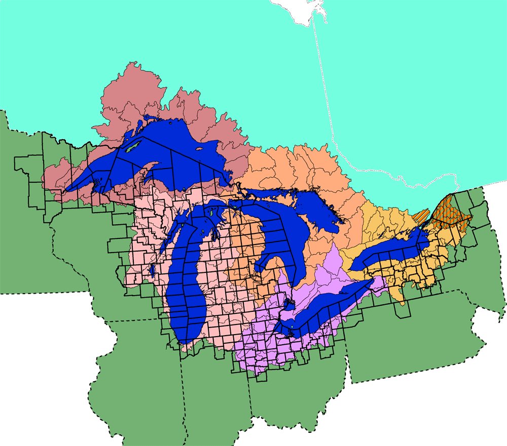
This connected layout explains why many scientists and agencies discuss the Great Lakes Basin as one system. The basin includes land whose water drains into the lakes and their connecting channels. The NOAA overview describes the Great Lakes as the world’s largest group of freshwater lakes by total area, a scale that makes their linked behavior important far beyond any single shoreline.
Connections allow changes to travel through the system, although each lake responds in its own way. Strong winds can push water toward one end of a lake. Seasonal ice, evaporation, rain and tributary flow affect water levels. Looking across the full chain helps researchers and managers see how local conditions fit into a wider freshwater network.
5. One count serves many purposes
Counting five lakes keeps geography easy to follow. Each name points to a recognizable place with its own ports and beaches. Its habitats, weather patterns and history are distinctive too. The five-lake count also matches the wording used by the EPA and other public institutions when they describe the region.
Scientists may choose a different grouping when they study water levels, circulation, or the movement of pollutants and nutrients. For Lake Michigan and Lake Huron, the open straits and equal surface height make the combined Michigan-Huron view valuable. A study question about flow can therefore use a different unit than a map quiz or a travel plan.
Clear definitions prevent an apparent disagreement from becoming confusing. A publication can refer to five named Great Lakes and still analyze Michigan-Huron as one hydrologic water body. The count reflects the question being asked. Geography, public communication and regional history favor the five names. Water-level science can favor the combined unit.
Both views make the Great Lakes easier to understand when their purpose is clear. The standard answer is five named lakes. The hydrologic connection between Michigan and Huron adds a memorable detail about their shared water, rather than changing the names people see on maps. Research from the U.S. Geological Survey’s Great Lakes Science Center and regional coordination through the Great Lakes Commission reflect the value of looking at both individual lakes and the connected system.
Explore the Great Lakes
The five-lake overview is the starting point for a connected group of explainers. Read how glaciers formed the Great Lakes, follow the channels connecting the lakes, or compare the largest lakes in North America.
Individual-lake guides cover Lake Superior’s depth, Lake Michigan’s water volume, swimming conditions in Lake Michigan and Lake Erie’s hazards.
More Great Lakes guides
Explore Lake Huron’s depth, meet the fish living in Lake Michigan, or learn how thousands of islands fit into the Great Lakes.
More Great Lakes guides
Continue with what lives at the bottom of Lake Superior, rocks and minerals found around Lake Michigan, habitat loss across the Great Lakes, the Lake Michigan watershed.
More Great Lakes reference pages
Continue with the Lake Superior Circle Tour, how Lake Erie formed, animals of Lake Michigan, 15 Great Lakes attractions.
The lakes touch eight states on the U.S. side. Argo lists the eight Great Lakes states and explains Lake Michigan surf fishing.
Argo’s newer reference guides add a Great Lakes topographic map and elevation profile, Great Lakes plant guide and Lake Superior invasive-species overview.





