
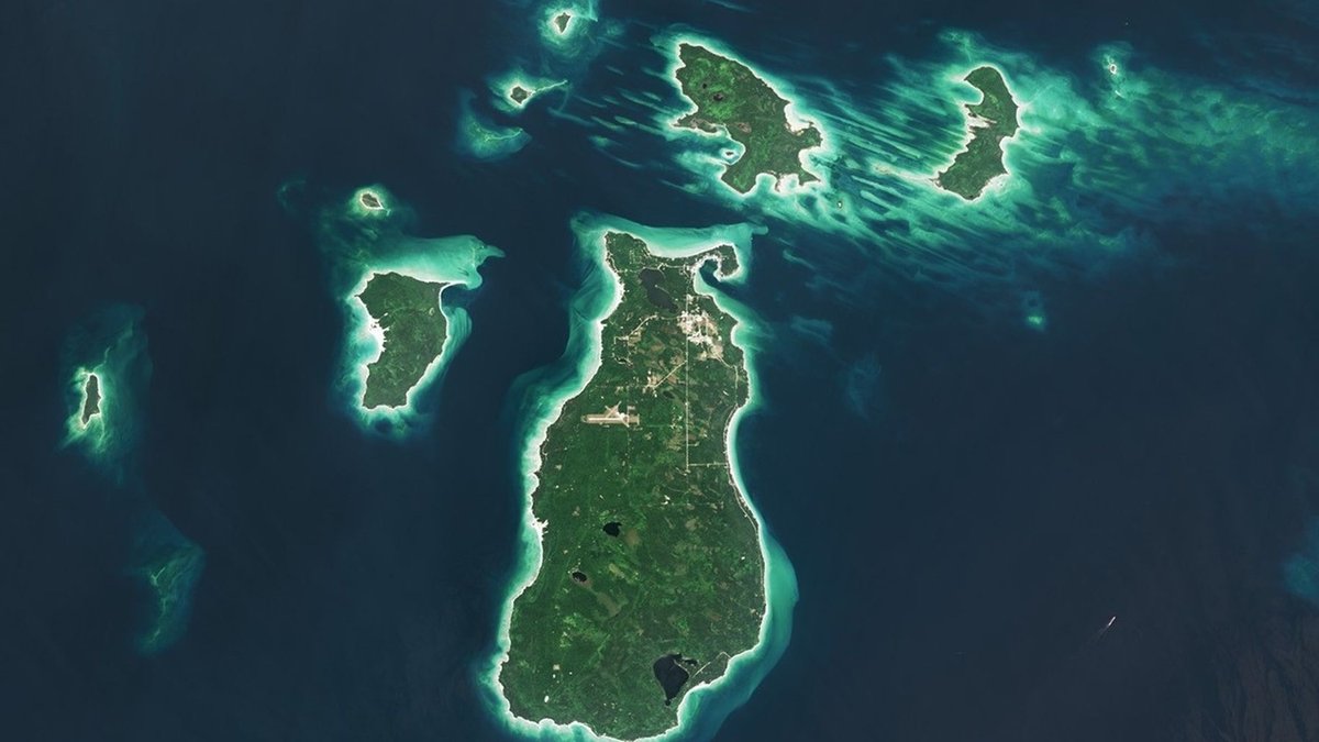
The Great Lakes hold the world’s largest collection of freshwater islands, but there is no single count accepted for every purpose. The U.S. Geological Survey describes about 30,000 islands, while the Great Lakes Islands Alliance uses 32,000. A current Canadian overview reports more than 35,000 across the Great Lakes. A separate government map assigns more than 30,000 to the Lake Huron system alone. Each figure depends on geographic scope. Map scale and the definition of an island also change the result.
Some entries are vast inhabited lands with roads and towns. Others are bare rocks that rise only slightly above the water. A small outcrop can disappear from a count when lake levels rise and digital mapping can separate rocks that an older inventory treated as one feature. The USGS island system was built to help managers compare natural values and threats, so its working definition reflects a conservation database rather than a final geographic census.
Most Great Lakes islands cluster around Lake Huron. Georgian Bay and the North Channel contain particularly dense archipelagos. Their variety ranges from Manitoulin Island, the largest island in a freshwater lake, to thousands of uninhabited skerries along rocky coasts. The archipelagos are spread across all five Great Lakes and reveal how bedrock, glaciers and changing water levels created the modern landscape. They also support rare habitats and communities whose daily lives depend on water crossings.
Why island counts differ
An island count begins with a boundary. Some inventories include islands in connecting channels such as the St. Marys River, Lake St. Clair and the St. Lawrence River. Others count only land surrounded by the five named lakes. The choice can move thousands of small features into or out of the total. Readers comparing estimates should check whether a source means the lakes themselves, the Lake Huron drainage system or the broader Great Lakes basin.
Size thresholds create another difference. The USGS description covers landforms ranging from small boulders to islands larger than 100,000 acres. A database may require a feature to remain above a selected water elevation, while a community network naturally concentrates on islands with permanent or seasonal residents. Shoreline detail also changes with map resolution. A coarse map can join adjacent rocks, whereas high-resolution imagery may show narrow water gaps between them.
Lake levels are dynamic. Storms can expose low shelves or cover them again. Longer seasonal and climate cycles move the shoreline over time. Erosion can split a fragile landform, while sediment may connect a nearshore island to the mainland. The Great Lakes Islands Alliance therefore presents 32,000 as a regional description. Its network focuses on nearly 20 islands that still host communities, so its count and the USGS estimate answer different practical questions.
Lake Huron holds the main concentration
The eastern and northern sides of Lake Huron contain immense fields of islands. The Canada Water Agency reports more than 30,000 islands in the Lake Huron drainage basin. Their shorelines help give Huron the longest shoreline of any lake in the world. Georgian Bay’s eastern edge alone is widely known as the 30,000 Islands, an archipelago of exposed Canadian Shield rock.
Georgian Bay and the North Channel account for much of the apparent conflict between regional totals. Sources may treat Georgian Bay as part of Lake Huron, as hydrologists generally do, while a travel or local inventory may label it separately. Connecting passages add more decisions. Anyone asking whether the Great Lakes are connected is also asking where one water body ends and the next begins.
The other lakes contain important archipelagos even though their counts are smaller. Lake Superior includes Isle Royale and more than 400 nearby islands within the national park, plus the Apostle Islands along Wisconsin. Lake Michigan has the Beaver Island group and islands around Green Bay. Lake Erie contains compact island groups near the western basin, while Lake Ontario’s islands continue toward the upper St. Lawrence.
The largest and best-known islands
Manitoulin Island sits in northern Lake Huron and is the world’s largest island located in a freshwater lake. It is large enough to contain lakes of its own and some of those lakes contain islands. The island is home to several First Nations and municipal communities. Roads connect its towns internally. A seasonal ferry and a bridge at Little Current connect residents with mainland Ontario.
Isle Royale is the largest island in Lake Superior. The U.S. National Park Service describes it together with more than 400 smaller islands as a remote, forested archipelago. Visitors arrive by ferry or seaplane because there are no public roads connecting it to the mainland. Private boats provide another route. Long-running research on Isle Royale’s wolves and moose has also made the island well known far beyond the Great Lakes region.
Other notable islands reflect different parts of Great Lakes life. Beaver Island is the largest island in Lake Michigan. Mackinac Island lies at the meeting point of Lakes Michigan and Huron and supports a year-round community alongside heavy seasonal tourism. Pelee Island sits in Lake Erie near the international boundary. Madeline Island is the largest of Wisconsin’s Apostle Islands, while Wolfe Island stands near Lake Ontario’s outlet into the St. Lawrence River.
Bedrock and ice produced different island forms
The islands did not all form through one process. Ancient bedrock supplied durable ridges and shelves. Rocky knobs also remained above water. Repeated ice sheets then eroded softer material and deepened the surrounding basins. As the glaciers retreated, meltwater filled the basins and left higher ground isolated. The broader story follows the same glacial history that explains how the Great Lakes formed.
Regional geology gives each archipelago a distinct appearance. Along eastern Georgian Bay, glaciers scoured ancient Canadian Shield rock into rounded pink and gray surfaces with narrow channels between them. The Parks Canada management plan places Georgian Bay Islands National Park where the Precambrian Shield meets the St. Lawrence Lowlands. Forest communities change across that transition, even over a short distance.
Lake Superior’s islands expose a different record. The National Park Service links Isle Royale’s long ridges to billion-year-old lava flows, later scoured by glacial ice. In the Apostle Islands, resistant sandstone knobs remained as the ice eroded surrounding rock. Retreating ice and shifting lake levels then exposed the archipelago, according to the park’s geology account.
Small islands can carry unusual habitats
Isolation and extensive shoreline make the islands valuable for wildlife. The USGS inventory highlights endemic plants and threatened species among its conservation concerns. Migratory birds also depend on island habitats. An island may provide a nesting site beyond the easy reach of mainland predators. Shallow water around another island can support spawning habitat or coastal wetlands. Value depends on location and condition rather than acreage alone.
Georgian Bay shows how much diversity can fit into a small protected area. Parks Canada reports at least 25 federally listed species at risk across the national park’s 14 square kilometres. The park spans southern hardwood forest and northern exposed-rock communities. It also protects habitat for more than 30 amphibian and reptile species, including 13 species at risk. Such concentration helps explain why conservation planners need detailed island-level maps.
Invasive plants and development pressure island ecosystems, while fluctuating water levels create a separate challenge. Boat traffic can carry organisms between shorelines. Construction may remove habitat from a narrow coastal strip that represents a large share of a small island’s area. Conservation decisions must account for water around the island as well as land above it because nearshore habitat links nesting areas, fish populations and submerged vegetation.
People have lived among the islands for millennia
Great Lakes islands are cultural landscapes as well as physical features. Indigenous peoples have traveled these waters and harvested food for thousands of years. Their communities have endured across the same region. Parks Canada records at least 5,500 years of human activity around Beausoleil Island. Manitoulin and many nearby islands remain part of living Anishinaabe homelands, with cultural relationships extending across shorelines and political boundaries.
Modern year-round island communities share practical constraints. Ferry schedules and ice conditions influence access to health care and schools. Weather can interrupt either route. Infrastructure costs can be high because equipment and materials must cross water. Tourism may supply substantial seasonal income, yet it also increases demand for housing and public services. The International Joint Commission has described how island leaders created a binational network to exchange solutions while recognizing that water quality connects communities upstream and downstream.
Only a tiny fraction of the thousands of mapped landforms support permanent settlements. The inhabited islands still show why a simple total cannot describe the region. A bare rock used by nesting birds, a protected forest archipelago and an island with towns can each appear as one record in a geographic database. Together, the Great Lakes islands form a freshwater landscape whose meaning reaches far beyond the count.





