Shoreline armoring is the use of hard structures such as seawalls, rock revetments and bulkheads to hold a coast in place or protect development from erosion and waves. It can defend a building or road, yet it may also narrow beaches and interrupt the natural movement of sediment.
NOAA’s explanation of shoreline armoring emphasizes the tradeoff. A structure can reduce erosion immediately behind it while changing habitat and public beach space nearby. The consequences depend on the structure and local geology, along with the wave climate.
Why shorelines move
Waves pick up sand and move it along or across the coast. Storms can remove a large volume in a day, while calmer conditions may return some material over a season. Rivers and eroding bluffs replenish certain beaches. Others depend more heavily on offshore deposits.
Sea-level rise allows waves to reach farther inland. In places where dunes or wetlands have room, the shoreline can migrate. Buildings and roads restrict that movement, creating pressure to defend a fixed line.
Human actions also alter the sediment budget. Dams retain material upstream, while harbor structures trap sand on one side. Dredging redistributes still more sediment. Before choosing a response, coastal engineers study whether erosion reflects a temporary event or a long-term shortage of sediment.
Common types of shoreline armor
A seawall forms a steep barrier between land and water. Concrete walls can resist strong waves but may reflect energy toward the beach. A bulkhead has a similar upright form and is often used along sheltered waterways to retain soil.
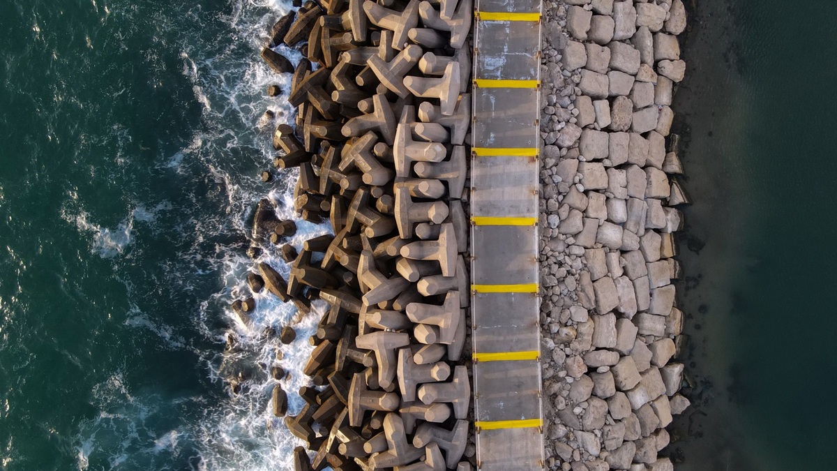
A revetment covers a slope with rock or concrete units. Its rough, angled surface dissipates some wave energy. Riprap is a common version made from large stones, usually placed over filter fabric and a graded foundation.
Breakwaters sit offshore and reduce the wave energy reaching land. Groins extend outward from a beach to catch sand moving alongshore. Because trapped sand is no longer available to the coast farther down-current, groins can shift an erosion problem rather than eliminate it.
Each design requires maintenance. Waves can scour the base of a wall, while stones may move. Water can also drain through weak points. Failure can be sudden if a structure is poorly matched to the site.
How armoring can narrow a beach
A natural beach often moves landward as water level rises. A wall blocks that migration. Waves continue working against the fixed barrier and the exposed beach may become progressively narrower in a process called coastal squeeze.
Reflected wave energy can increase turbulence near a vertical wall. Local scour may lower the beach directly in front of the structure. The importance of reflection varies with beach shape and construction, so researchers evaluate it at the site rather than assuming the same outcome everywhere.
Narrowing affects more than recreation. Intertidal animals lose feeding space and sea turtles may have less dry sand for nesting. Public access can disappear at high tide even when a legal right to reach the shore remains.
When hard protection may be justified
Armoring can be appropriate where critical infrastructure cannot readily move. A port or wastewater plant may need dependable protection while a longer adaptation plan is developed. The same can apply to an evacuation route. Dense urban waterfronts also leave little room for a naturally migrating shoreline.
Engineers examine expected wave forces and foundation conditions, then set the structure’s design life. They also consider what happens at each end, where an armored segment meets an unprotected coast. Permitting agencies may require analysis of neighboring properties and aquatic habitat.
The FEMA coastal construction guidance explains how waves and erosion affect buildings in hazard zones. Separate state and local rules determine whether a new protective structure is allowed. A technically feasible wall may still conflict with beach-management policy.
Softer approaches work with natural processes
Beach nourishment adds compatible sand to restore width. The project retains a flexible shore, although waves eventually move the new material and periodic replacement may be needed. Dunes can store sand and reduce storm impacts when vegetation and public access are managed carefully.
Living shorelines use plants and natural materials in relatively sheltered settings. Oyster reefs or low rock sills may reduce wave energy while maintaining habitat connections. NOAA provides a living shorelines overview that describes where these approaches can support both stabilization and ecosystems.
Hybrid projects combine natural features with limited structural support. Their performance depends on exposure; a technique suited to a quiet estuary may fail on an open-ocean beach. The U.S. Army Corps Engineering With Nature program develops guidance for incorporating natural processes into infrastructure projects.
Relocation is another option when a structure has space to move and repeated defense would be costly. Managed retreat can preserve the shore’s ability to migrate, but it requires funding and community agreement. No single alternative fits every coast.
How communities choose a response
A useful assessment begins with erosion rates and maps the assets at risk. It identifies who benefits and who may bear new costs. A separate analysis follows sediment beyond the project boundary. Monitoring should continue after construction so unexpected erosion can be detected.
The Digital Coast provides elevation and land-cover data, alongside coastal-hazard resources for local planning. The USGS Coastal and Marine Hazards program studies shoreline change and storm impacts. These datasets help distinguish a visually dramatic episode from a persistent trend.
Shoreline stabilization is ultimately a choice about how a coast will function over decades. Hard armor can protect a fixed asset, but its footprint and downstream effects need to be counted. The strongest plan compares several methods and selects the smallest intervention that can meet a clearly defined need.
Monitoring reveals whether a project works
Before construction, teams can survey beach profiles and photograph fixed reference points. Sediment measurements establish how the shore changes through seasons and storms. Without a baseline, later observations may show a narrow beach without revealing whether the structure accelerated the change.
Post-project surveys examine the wall or revetment and the shore beside it. Scour at the toe can weaken the foundation. Erosion at the ends may indicate that the defended segment is affecting adjacent land, while sand accumulation can reveal a change in alongshore transport.
Biological monitoring looks beyond physical stability. Researchers may count plants in a marsh or measure the width of intertidal habitat. A structure can remain intact while the ecological conditions it was meant to preserve continue to decline.
Clear objectives support adaptation
Extreme storms provide demanding tests, but routine observations are valuable too. Small losses repeated over many tides can add up. Maintenance records show whether the apparent security of armor depends on frequent repairs that were missing from the original cost estimate.
Communities can set measurable objectives before choosing a design. Protecting one road for 20 years is a clearer goal than stopping all erosion. A defined objective makes it possible to compare armor with nourishment, elevation or relocation on cost and performance.
Monitoring can also trigger adaptation. A project may begin with vegetation and a low sill, then add protection if thresholds are crossed. This staged approach preserves options and lets real site behavior inform later investment instead of committing immediately to the largest structure.
Property-level decisions accumulate along a coast. Many small walls can create a nearly continuous barrier even when each permit appeared limited. Regional planning reveals those combined effects and helps communities preserve stretches where dunes or wetlands can still migrate.
Funding rules can favor construction over maintenance or relocation, influencing which option appears affordable. A fair comparison includes inspection and repair, followed eventually by replacement. It should also count public beach loss or habitat effects that do not appear on a property owner’s invoice.
Related reading: how living shorelines differ from hard armor and how waves change near shore.