
Five inland seas now hold water across the heart of North America, yet their familiar outlines are the latest chapter of a much older landscape. The Great Lakes took shape through rock weathering and river erosion. Repeated ice advances, melting ice and slow changes in the height of the land continued the process over immense spans of time across what is now Canada and the United States.
The final retreat of the Laurentide Ice Sheet released enough meltwater to fill low ground, but the basin pattern had deeper roots. The Wisconsin Sea Grant account traces how outlets shifted for thousands of years as ice withdrew and the crust responded to the vanished weight.
A lake’s identity depends on its basin, outlets and water history. Bedrock strength helped steer the ice. Sediment blocked and redirected rivers. Water escaped through several routes before the linked system of Superior, Michigan and Huron joined Erie and Ontario in its present arrangement roughly 3,000 years ago.
Old bedrock and river valleys set the pattern
Long before the latest ice age, rivers crossed a landscape built from sedimentary rock. Some layers were tougher than others. Softer shale and other weak rock could wear down more readily, while stronger uplands remained higher. Rivers also cut valleys into that uneven surface, creating lines of low ground near parts of the future lake basins.
Preglacial river valleys supplied a framework for the later landscape. Low pathways could guide and deepen under moving ice, while surrounding uplands influenced its route. A USGS report on the Michigan basin describes an older surface-drainage network in large valleys near the present lakes. It also says later ice advances made those valleys more pronounced as they scoured the bedrock.
The bigger regional lesson comes from USGS mapping. Across the glaciated United States, the landscape changed through erosion, redeposition and disruption of older drainage. The lake basins therefore preserve a layered history. Ancient rock and valleys supplied the starting relief, then ice and water repeatedly altered it.
Rock type helps explain why the lakes vary so much. Lake Superior occupies a basin tied to very old and resistant rocks, while the shallower Lake Erie basin crosses softer sedimentary layers. Each basin also has its own mix of buried valleys, ridges, sediment and bedrock. The five lakes became a connected system, but their foundations were never identical. To trace these hidden features, geologists combine drill cores, sediment samples and maps of the bedrock surface. Their work builds a three-dimensional record of the region beneath soil, water and glacial deposits. It helps researchers distinguish an older valley from a newer sediment-filled channel.
Ice reshaped the basins again and again
During the Pleistocene, continental ice sheets moved into and out of the region many times. The ice was thick enough to press down the land beneath it. As it flowed, it carried rock fragments that scraped the ground. It also picked up material and left it elsewhere when conditions changed. Glacial erosion deepened some low areas and built ridges of debris in others.
The last major sheet in the region is called the Laurentide Ice Sheet. Its lobes flowed through lower terrain and spread around higher ground. Repeated ice movement helped reinforce the broad pattern of the basins. The Great Lakes Geologic Mapping Coalition says the region experienced repeated glacial advances and retreats over the last million years, with widespread effects on both sediments and underlying bedrock.
Every advance combined erosion with deposition. Ice left glacial sediment that included clay and sand. Gravel and boulders were also deposited. Glacial deposits could dam valleys, form hills called moraines and reshape watershed divides. A later advance could erode or rework older deposits. The modern landscape carries the accumulated results of many ice and meltwater episodes.
When the climate warmed after the last glacial maximum, the ice margin pulled back in stages. The retreat exposed basins while meltwater and rainfall began to collect. NOAA summarizes the broad timing by placing the warming and retreat at about 20,000 years ago. Individual shorelines and outlets developed at different times because the retreat moved across the region in stages.
Meltwater found changing routes
Water followed the lowest route available at each stage of retreat. Ice still blocked some northern and eastern paths, so early lakes spilled south or west through channels that subsequently ceased serving as their main outlets. Lake Erie and an early Lake Michigan drained toward the Mississippi system about 10,000 years ago. Wisconsin Sea Grant identifies that early Michigan basin as Lake Chicago.
Lake Superior had an early phase called Lake Duluth. Around 9,000 years ago it drained southwest through the St. Croix and Mississippi river system. As the ice margin moved north, the upper lakes could temporarily join a much larger water body known as Lake Nipissing. Wisconsin Sea Grant describes it as having three outlets, toward the Ottawa-St. Lawrence, Detroit-St. Clair and Illinois-Mississippi systems.
Temporary lake connections show why Great Lakes history is a moving map. Ice can block a river. A lake can rise until it overtops a new divide. Fast meltwater can cut or enlarge an escape channel. Sediment can fill one path while a lower path opens elsewhere. The lakes and their rivers repeatedly reorganized as those controls changed.
By about 7,000 years ago, land southwest of Lakes Erie and Michigan had risen enough to end their southwestern drainage and Lake Ontario and the Niagara River outlet developed. Lake Huron continued to drain east through the Ottawa-St. Lawrence system until roughly 5,000 to 6,000 years ago. Lake Michigan still used the Illinois River route near Chicago until about 3,000 years ago.
The land is still rising
Ice shaped the ground through its movement and through its immense weight. The ice sheet’s weight bent the crust downward. When the ice melted, its removal began a slow upward response called isostatic rebound. Rebound proceeds at different rates across the basin, tilting parts of the Great Lakes region and helping change which outlets lie lowest.
Scientists measure this motion with precise surveys, shoreline features and records of changing relative water levels. Land near the center of former ice loading can rise faster than land farther away. Over thousands of years, even gradual differences in elevation can redirect water and leave ancient beaches, deltas and abandoned channels above or below today’s shorelines.
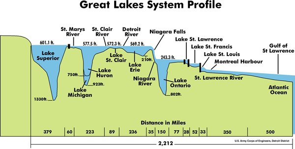
Postglacial uplift helped produce today’s stair-step flow from Lake Superior through the other lakes, over Niagara Falls and into the St. Lawrence River. It also explains why outlet history continued long after the ice had begun retreating. The change is slow by human standards, yet it remains geologically active. Shorelines and water levels respond to many influences, including seasonal weather, long-term climate patterns and the changing land surface.
The National Oceanic and Atmospheric Administration notes that the Great Lakes reached their present shapes and sizes about 3,000 years ago. “Present” names the broad linked layout seen on a map. Erosion, sediment movement, changing water levels and ongoing crustal rebound continue to adjust the setting around the lakes.
Seen this way, the Great Lakes are a record of connected processes. Bedrock geology set weak and strong zones. Glacial erosion and deposited sediment reshaped the relief through many cycles. Meltwater linked and separated temporary lakes, then changing outlet heights organized the flow we know today. Their formation remains visible in the rivers, ridges, shorelines and rising land around them.
The resulting basins now form the five named lakes described in Argo’s Great Lakes overview. Their present-day water route is mapped in how the Great Lakes connect.
The same glacial history left a complex shoreline and thousands of islands across the Great Lakes.
The modern basin spans the jurisdictions in Argo’s guide to the eight U.S. Great Lakes states. One practical use of the resulting shoreline appears in Lake Michigan surf fishing.
The glacial basins can also be read through Argo’s Great Lakes topographic map and Lake Michigan contour map.





