
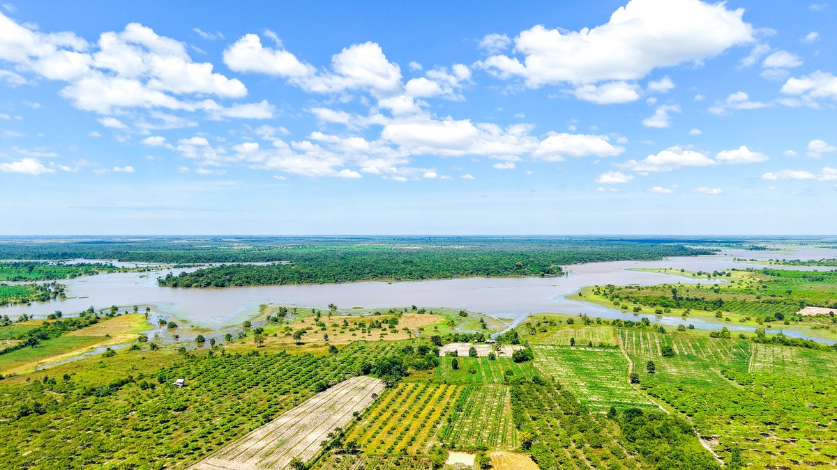
River anatomy describes the connected parts of a flowing-water system. Water begins in headwaters, gathers in tributaries, enters a channel bounded by banks and moves across a watershed toward a mouth. Along the way, the bed, meanders, floodplain and confluences record how flow interacts with rock, soil, sediment and vegetation.
The terms work at different scales. Bed and banks belong to the immediate channel, which exchanges water with the adjacent floodplain during high flow. Both sit inside the watershed that gathers runoff from surrounding slopes. Understanding this nesting makes a flood report easier to connect with a map or habitat description.
Source and headwaters
A river’s source is its point or region of origin. It may be a spring, lake, wetland, glacier or collection of small channels. Many large rivers do not emerge from one dramatic point, so geographers use rules such as longest tributary, greatest discharge or traditional naming to identify a source.
Headwaters are the small upper streams and surrounding source area. They often have steeper gradients than the lower river, but not always. Headwater wetlands and groundwater can regulate flow, while storms can produce rapid rises in confined mountain channels.
The official source selected for a named river may differ from the hydrologically farthest headwater. A traditional map label can preserve historical naming, while a measurement may instead follow the branch with the greatest length or discharge. Both can be valid when the criterion is stated.
Tributaries and confluences
A tributary is a stream or river that enters a larger one. It contributes water, sediment, nutrients and organisms from its own drainage area. Tributaries form branching networks, with the smallest channels joining progressively larger streams.
A confluence is the place where two channels meet. The combined river may take the name of one branch or receive an entirely new name. Differences in temperature, sediment, chemistry or flow can remain visible downstream before the waters mix completely.
Hydrologists assign stream order to describe network position. One common system labels channels with no tributaries as first order and increases the order when two streams of equal rank meet. The resulting number describes branching position. It does not rate water quality or confer legal importance.
A USGS illustration of Strahler stream order shows channel rank increasing where branches of equal order meet. The resulting hierarchy represents a connected network rather than isolated lines. A change in a small tributary can propagate into the main stem through water, sediment or contaminants.
Channel, bed and banks
The channel is the corridor through which river water normally flows. Its shape reflects discharge, slope, sediment, vegetation and bank material. Some channels are narrow and single-threaded; others divide around bars into braided or anabranching patterns.
The bed is the channel bottom. Bedrock, boulders, gravel, sand, silt or clay may dominate. Flow erodes material where its force exceeds resistance. It carries the loosened particles downstream until a fall in velocity allows deposition. The result changes during floods and may vary from one bend or season to another.
Banks are the sides of the channel. Roots can bind bank soil, but fast water attacks the exposed surface and saturation weakens it from within. Bankfull flow roughly fills the channel before water spreads widely onto the floodplain, although identifying an exact bankfull level requires local field evidence.
Channel width and depth adjust to the amount of water and sediment commonly carried. After a major disturbance, the bed may aggrade, incise or shift laterally until transport and supply reach a different balance.
Meanders, pools and riffles
A meander is a bend created as flow erodes one side of a channel and deposits sediment on the other. Faster water commonly attacks the outer bank, forming a cut bank. Slower water along the inside builds a point bar.
As bends migrate, a narrow neck may be cut through during high flow. Sediment can isolate the abandoned loop as an oxbow lake. This migration lengthens the channel and reduces its effective slope, helping flow carry the available sediment without treating every bend as fixed.
Smaller channel units create contrasting conditions. A shallow riffle sends turbulent water over coarse material. Downstream, flow may settle into a steadier run before deepening and slowing within a pool. These units are central to river habitat because they provide different hydraulic conditions and refuges.
Floodplain and terraces
A floodplain is low land next to a river that can be inundated when water leaves the channel. Floodwater loses energy across the wider surface and deposits sediment. Repeated flooding can build natural levees near the banks and finer deposits farther away.
The FEMA flood-map program models hazard zones for management and insurance. Those maps use defined probabilities and should not be read as a promise that flooding stops at a boundary line.
Floodplains spread high water across a wider surface, which slows the current and allows nutrients to exchange with wetlands or forests. Development and levees can disconnect that space. A mapped regulatory floodplain expresses a defined probability and modeling standard, so it is not identical to every landform a geomorphologist calls floodplain.
A river terrace is an older floodplain surface left above the modern channel after incision. Its elevation preserves the river’s former position. Sediment within it may also record past climate or tectonic change. Ordinary floods no longer reach many terraces.
Watershed and drainage divide
A watershed is the land area that drains to a common outlet. Drainage basin and catchment are alternative names for the same concept. Rain falling within its boundary may reach the river by surface runoff, soil flow or groundwater. The USGS watershed guide explains that small basins nest within progressively larger ones.
A drainage divide is the high ground separating neighboring watersheds. A ridge can send rain from one slope toward one river and rain from the opposite slope toward another. Divides may be subtle on flat land and can shift through erosion or human diversion.
Watershed boundaries explain why activity far from the main stem can influence it. A tributary carries material from its own basin into the larger river, whether that material is dissolved fertilizer or sediment washed from a road. Urban runoff follows the same connection.
Mouth, delta and estuary
The mouth is where a river enters another river, lake, sea or ocean. As velocity decreases, the river may deposit sediment. If deposition builds outward faster than waves and tides remove it, distributary channels can spread across a delta.
An estuary is a partly enclosed coastal water body where river water mixes with seawater. A river can end in an estuary without building a large delta and a delta can contain estuarine zones. Tides may push salt water upstream while river discharge pushes freshwater seaward.
NOAA’s estuary definition emphasizes shelter and freshwater-saltwater mixing. River discharge pushes the salinity gradient seaward, while tides reverse part of that movement and storms can disrupt the usual balance.
Distributaries branch away from the main channel near some mouths, unlike tributaries that join it. Their positions may change as bars build and channels avulse across a delta plain.
Flow, discharge and river stage
Discharge is the volume of water passing a cross-section per unit time, commonly expressed in cubic feet or cubic meters per second. Stage is the water-surface height relative to a local reference. A rating curve converts stage readings to estimated discharge at many gauges.
The two values are related but not interchangeable. The same stage can correspond to a changed discharge if erosion, vegetation or ice alters the channel. Current gauge readings in river levels today need station-specific context.
The USGS National Water Information System publishes station observations and metadata. Before comparing locations, a reader should confirm the gauge datum and whether the sensor is operating normally. Provisional data carry an additional warning because they may be revised.
How the parts work as one system
The USGS overview of rivers and streams emphasizes continuous movement through the water cycle. A raindrop can enter a headwater tributary, pass a confluence, cross alternating riffles and pools, spread across a floodplain and eventually reach a mouth.
Those parts also create the landforms made by rivers. Erosion deepens a channel or attacks an outer bend, placing sediment into transport. Wherever current loses enough energy, deposition builds features that range from a point bar to a floodplain or delta. The network fits within the wider pattern of major rivers and drainage basins.
River anatomy is therefore relational. A tributary receives its name from joining another channel. The common outlet defines the watershed, while periodic escape of channel flow establishes the floodplain connection. Seeing those relationships is more useful than memorizing a list of isolated terms.
Channel shape is measured and interpreted by specialists described in Argo’s guide to fluvial geomorphology careers and field methods. Many of the resulting features are summarized in wetland landforms explained.
The same channel hierarchy appears at national scale in Argo’s map of U.S. rivers and lakes.
Stream measurements add another layer to river anatomy. Argo explains the difference between river stage and discharge, how groundwater sustains river baseflow and how perennial, intermittent and ephemeral streams differ.
A river’s visible parts sit within a larger branching network. Stream order ranks those branches, while a watershed or drainage basin identifies the land contributing water to a chosen outlet.





