
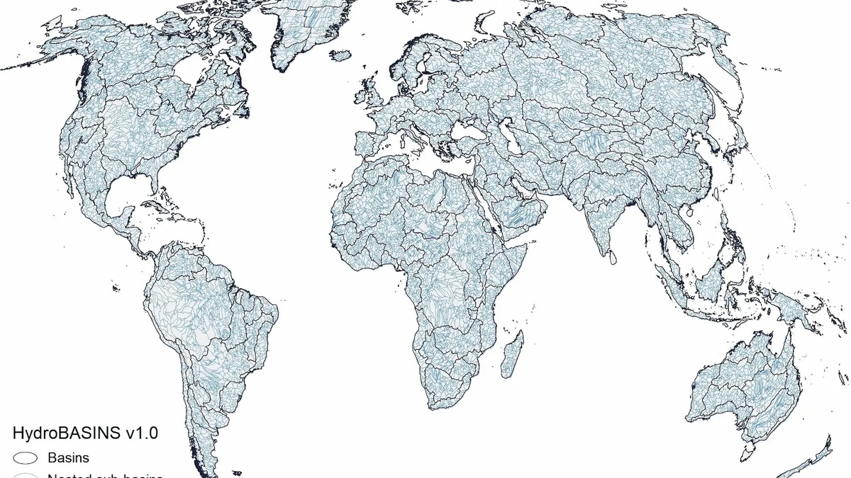
A world river map becomes easier to read when rivers are grouped by drainage basin and final outlet. Every basin contains land that drains toward one common outlet, which may be the Atlantic, Pacific, Indian or Arctic Ocean. Closed, or endorheic, basins instead end in an inland lake, wetland or dry depression.
The phrase “major river” has no single numerical threshold. The Global Runoff Data Centre map includes 520 basins selected for size, water quantity or hydropolitical importance. A different atlas may show fewer lines because it uses a coarser scale or a stricter definition.
A river line is smaller than its drainage basin
The blue line on a map traces a channel. Its basin is much broader because it includes the surrounding slopes and every tributary that feeds the main river. Basin boundaries follow drainage divides rather than national borders. One large basin can therefore contain thousands of tributaries and cross several countries.
Argo’s guide to river anatomy explains how tributaries join at confluences before water reaches a mouth. At world scale, cartographers omit most smaller tributaries so the principal network remains legible.
The World Bank publishes a downloadable major-basin dataset rather than one definitive wall map. Digital basin polygons allow users to compare river systems with climate, population or land-cover data.
Atlantic drainage includes the Amazon and Congo
The Amazon basin covers a vast part of northern South America and reaches the Atlantic on Brazil’s coast. The Amazon leads the world in discharge, but that does not settle every river superlative. Its reported length depends on which headwater a survey chooses. Basin area measures something different, as does the amount of water flowing past a point.
A classic USGS comparison estimated Amazon flow at more than four times the Congo’s and about ten times the Mississippi’s. Measurement periods and locations affect exact figures, so modern maps should avoid attaching one timeless discharge number to a river.
Africa’s Congo also reaches the Atlantic after draining a humid equatorial basin. The Paraná carries water from south-central South America into the Río de la Plata estuary. In North America, the Mississippi-Missouri system drains toward the Gulf of Mexico, part of the wider Atlantic ocean system.
European rivers reach several Atlantic seas
The Rhine drains to the North Sea, while the Seine and Loire enter the Atlantic through France. The Danube flows east into the Black Sea. Because the Black Sea connects through the Mediterranean, it belongs to the Atlantic system on many global drainage maps.
The Dnieper and Don also reach the Black Sea system. Iberian rivers such as the Tagus and Douro flow west to the Atlantic. Shorter rivers may be economically or ecologically important even when a global map omits their names.
Map labels can obscure the fact that seas act as intermediate receivers. A river may be described as draining to the Mediterranean, Baltic or North Sea without contradicting its eventual connection to the Atlantic.
The Indian Ocean receives major Asian and African rivers
The Ganges-Brahmaputra-Meghna network drains the Himalayas and a densely populated region before reaching the Bay of Bengal. The Indus flows toward the Arabian Sea. Farther east, the Irrawaddy enters the Andaman Sea.
Africa’s Zambezi reaches the Indian Ocean after passing through south-central Africa. The Limpopo also flows eastward. The Tigris and Euphrates join in Iraq, forming the Shatt al-Arab before water reaches the Persian Gulf.
These are drainage relationships, not rankings. A NASA-led water-availability study notes that major basins often lack evenly distributed observations. Satellites and land-surface models help fill gaps, but model estimates still carry uncertainty.
The Pacific basin spans both sides of the ocean
The Yangtze reaches the East China Sea near Shanghai after crossing China from the Tibetan Plateau. The Yellow River enters the Bohai Sea. The Mekong crosses or borders several Southeast Asian countries before reaching its delta in Vietnam.
The Amur forms part of the boundary between Russia and China before entering the Sea of Okhotsk. Across the Bering Sea in North America, the Yukon reaches that ocean basin from Alaska. Farther south, the Columbia enters the Pacific between Oregon and Washington. South America’s Pacific slope has many shorter rivers because the Andes stand close to the coast.
River width on a small-scale map does not represent discharge. NASA’s global work on river surface area identifies the Brahmaputra, Amazon and Lena among especially wide river networks, yet width remains a different property from length or flow.
Arctic rivers flow north from the continents
Russia’s Ob-Irtysh, Yenisey and Lena systems carry water north across Siberia to Arctic seas. North America’s Mackenzie drains a chain of rivers and large lakes into the Beaufort Sea. Their northward direction follows elevation, not a magnetic or hemispheric rule.
Seasonal freezing strongly affects Arctic discharge. Spring melt can arrive from the warmer south while downstream reaches remain ice-covered, raising the risk of ice jams. A static world map cannot show this annual pulse.
The new Argo guide to north-flowing U.S. rivers addresses the same basic misconception at a national scale. Compass direction has no inherent control over river flow; gravity follows the available downhill route.
Endorheic basins never reach an ocean
The Volga, Europe’s longest river, ends in the Caspian Sea. The Amu Darya and Syr Darya belong to the Aral Sea basin, although diversions have greatly altered whether and how much water reaches that inland endpoint. Central Asia’s Tarim River also occupies an endorheic basin.
Southern Africa’s Okavango commonly spreads into an inland delta in Botswana rather than reaching the sea. Some endorheic rivers lose water to evaporation and infiltration before a persistent terminal lake forms. Their mapped mouth may therefore move with climate and flow.
The GRDC map explicitly includes endorheic drainage alongside ocean-connected basins. This prevents a large closed system from disappearing merely because it lacks a marine outlet.
Largest, longest and highest discharge are different
The Amazon is the clear leader by discharge, as discussed in Argo’s article on the largest river by water volume. Length comparisons between the Nile and Amazon depend on headwater selection and measurement method. Neither question is answered by the width of a line on a map.
Basin area measures the land draining to an outlet. River length measures a route through the network. Discharge measures water passing a point over time. NASA’s recent global river accounting adds storage, the water present in channels, as another distinct quantity.
Fresh water in rivers is also only a small part of Earth’s total. Argo’s overview of where freshwater is stored places flowing water beside ice and groundwater reservoirs.
Why world river maps disagree
Scale controls which tributaries and small coastal basins appear. Every basin dataset establishes a minimum area for inclusion. Its designers must also represent artificial diversions and decide where intermediate seas belong within ocean categories. Political boundaries and disputed place names add a separate cartographic problem.
The GRDC’s revised dataset uses HydroSHEDS-derived basin boundaries and a common outlet, or pour point. Its data portal connects mapped basins with available discharge stations, while warning users through the data itself that monitoring density varies.
A useful map should therefore state its scale, date and selection method. It can show where major rivers drain, but it cannot by itself prove which is “largest,” predict seasonal flow or resolve every disputed headwater.
Projection also affects appearance. A world map can enlarge high-latitude basins and compress other regions, making a Siberian watershed look disproportionately large. Area comparisons should come from geospatial data, not visual judgment of a printed map.
Human engineering changes the visible network without erasing natural topography. A canal can transfer water across a divide, while a reservoir may drown the former channel. Irrigation introduces a different change by reducing flow before the river reaches its mapped mouth. A basin layer describes where water would drain through the represented network, while current discharge requires dated observations. Seasonal channels may also disappear temporarily.
Readers looking for a closer regional view can use Argo’s U.S. rivers and lakes map. The Great Rift Valley map shows how tectonic basins reorganize drainage in East Africa.





