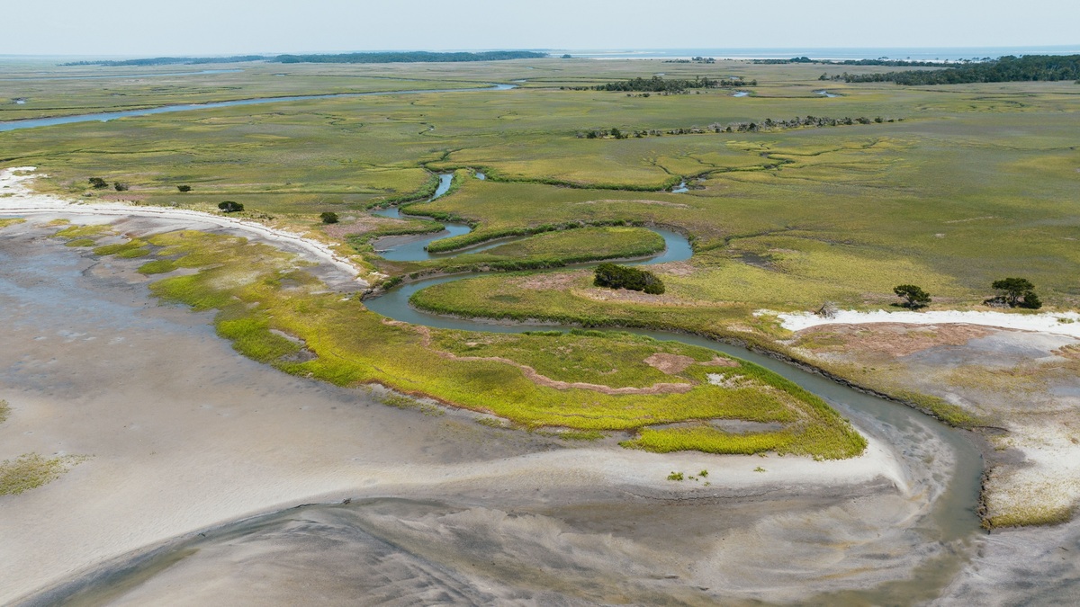
A salt marsh is a coastal wetland that floods and drains with the tide, usually along protected estuaries and bays. Salt-tolerant grasses, rushes and low plants cover mud rich in organic matter. The marsh may look flat and quiet, but its creeks, pools and vegetation support fish, shellfish, birds and small invertebrates. Each tide rearranges access to feeding ground and shelter.
Its position between land and sea gives it two jobs at once. A marsh is productive wildlife habitat and it can slow waves, store floodwater, trap sediment and process nutrients. NOAA’s salt marsh overview describes these wetlands on protected shorelines from the Arctic to the subtropics.
Tides build the rhythm of a salt marsh
Ocean water enters through branching creeks as the tide rises. Low areas flood frequently, while the upper marsh may receive saltwater only during higher tides or storms. Small differences in elevation therefore create large differences in salinity, soil saturation and plant cover.
Water slows as it spreads across stems and shallow ground. Suspended particles settle, gradually adding mineral sediment. Dead roots and leaves add organic material, producing the dark mud or peat typical of many marshes.
Saturated soil contains little oxygen because water fills spaces that would otherwise hold air. Microbes use other chemical pathways while decomposing material, sometimes producing hydrogen sulfide and its familiar sulfurous odor. Low-oxygen sediment is a normal feature, not proof that the wetland is dead.
Salt-tolerant plants organize the landscape
Marsh plants cope with salt, flooding and unstable soil. Some exclude much salt at their roots, while others tolerate salt inside tissues or release it through leaves. Air channels in stems and roots help move oxygen into waterlogged sediment.
Plant zones often follow elevation. Smooth cordgrass commonly occupies frequently flooded edges along the Atlantic and Gulf coasts, while saltmeadow cordgrass and other species grow higher. Regional floras differ, so one species list cannot describe every marsh.
Roots and rhizomes bind sediment and help the surface resist erosion. Dense shoots slow moving water above ground. Together, belowground growth and trapped particles can raise marsh elevation, an essential response where sea level is rising.
The Smithsonian Environmental Research Center explains how salt marsh plants respond to global change. Their growth depends on carbon dioxide, nutrients, flooding and sediment supply, which means elevation gain is biological as well as physical.
Creeks and flooded grass become nursery habitat
At high tide, small fish and crustaceans enter flooded vegetation to feed and avoid some open-water predators. At low tide, many retreat into tidal creeks and pools. Repeated movement transfers energy between marsh surface and estuary.
Juvenile fish, shrimp and crabs use marsh edges where stems create cover. Snails graze plants and algae. Mussels filter water or live among roots, while insects connect the marsh to birds and terrestrial predators.
Dead plant tissue also feeds the system. Fungi and bacteria break litter into smaller material consumed by invertebrates. Some organic particles leave with the tide and support food webs beyond the marsh.
NOAA Fisheries identifies coastal wetland habitat as important to fisheries and wildlife. Use varies by coast and season, but the shallow, structured edge is consistently valuable.
Marshes filter water without making pollution harmless
Slow water allows sediment to settle before it reaches bays or seagrass beds. Plants and microbes take up or transform some nitrogen and phosphorus. These processes can improve water quality when inputs remain within the ecosystem’s capacity.
A marsh is not an unlimited treatment plant. Heavy nutrient loads can alter plant growth, weaken soil or drive low oxygen in nearby water. Toxic chemicals and plastics can accumulate in sediment or organisms.
Watershed management remains necessary because rivers, roads and drainage systems deliver material from far inland. Protecting the wetland while allowing uncontrolled pollution upstream would ask it to absorb more than it can safely process.
Vegetation can reduce waves and flooding
Stems create drag as water crosses a marsh, reducing some wave energy. Broad marsh platforms also provide space for stormwater. The amount of protection depends on marsh width, elevation, vegetation and the event itself.
These benefits complement rather than guarantee coastal safety. A severe storm can flood beyond the marsh and eroded or fragmented wetlands provide less resistance. Roads and buildings placed directly behind them can also prevent landward migration.
The EPA’s summary of wetland benefits includes flood storage, water quality and wildlife habitat. Salt marshes deliver these services through connected vegetation, soil and tidal channels.
Sea-level rise creates a race for elevation
A healthy marsh can keep pace with modest change by trapping mineral sediment and accumulating roots. If water rises faster than the surface builds, plants spend too long submerged and the outer marsh may convert to mudflat or open water.
Migration inland can preserve habitat where the ground slopes gently and remains undeveloped. Seawalls, roads and steep terrain create a squeeze between rising water and a fixed boundary. Sediment starvation from dams or dredging can compound the problem.
Restoration may reopen tidal flow, remove obsolete barriers, add sediment or reconnect creeks. Success requires the correct elevation and water movement, not simply planting grass. Monitoring should track plant cover, surface height, channel form and animal use.
A salt marsh is ultimately a moving boundary maintained by tides and living plants. Its apparent stillness hides daily exchanges of water, food and sediment. Keeping room for those exchanges is central to preserving both habitat and coastal protection.
Marsh boundaries also mark transitions into mudflats, dunes, forests or developed land. Animals cross those edges daily, so a narrow vegetation strip cannot replace a connected coastal landscape with upland refuge.
Scientists measure whether a marsh is keeping pace
Surface-elevation tables measure tiny vertical changes relative to a stable benchmark driven into the ground. Marker horizons show how much new sediment has accumulated above a known layer.
Vegetation plots record species, stem density and bare patches. A shift toward plants that tolerate more frequent flooding can precede visible conversion to open water.
Water-level gauges establish how long each elevation remains submerged. Combining those records with marsh surface elevation shows whether soil is gaining height quickly enough relative to local sea level.
Aerial images reveal channel expansion, shoreline retreat and pond formation over large areas. Field measurements remain necessary because a green canopy does not show weak roots or subsiding soil.
Monitoring informs choices about sediment addition, barrier removal or migration corridors. The objective is not to freeze every channel in place, but to preserve tidal wetland function as the coast changes.
Marsh carbon is stored mainly belowground
Plants move carbon into roots and rhizomes as they grow. Dead material becomes buried in wet, oxygen-poor soil where decomposition can proceed slowly, building coastal carbon stores over long periods.
Storage differs among sites because temperature, sediment and plant production vary. Measuring only living leaves misses much of the carbon below the surface.
Drainage exposes organic soil to oxygen and can accelerate decomposition. Erosion can also carry stored material into open water, where its eventual fate is difficult to follow.
Protecting existing marsh often avoids emissions more reliably than promising future storage from an unproven restoration. Carbon accounting should include methane, project boundaries and the possibility that the habitat may later be lost.
The climate benefit adds to habitat and flood reduction rather than replacing them. A healthy salt marsh delivers several functions through the same living soil. Managers therefore evaluate carbon together with elevation, vegetation and tidal exchange. A project that stores carbon but blocks fish passage would not restore the full connected coastal ecosystem over many future years.
Related reading: living shorelines and national marine sanctuaries.