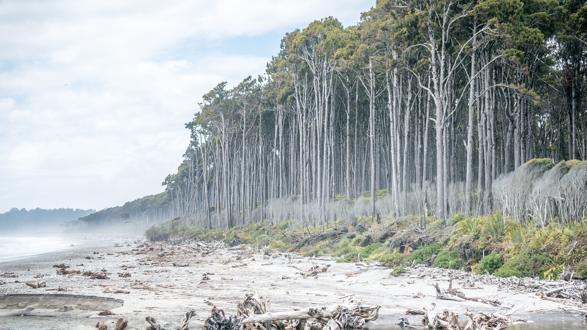
A ghost forest is a stand of dead or dying trees left where a living coastal forest has been exposed to saltwater, prolonged flooding, erosion, or another severe environmental change. Bare gray trunks may remain upright for years as marsh plants spread beneath them. Along low coasts, the scene often marks a landward shift of tides and salinity.
NOAA’s ghost forest explanation links many examples to sea-level rise and saltwater encroachment. Storm surges, drought, drainage ditches, land subsidence and shoreline erosion can accelerate the change. The trees are the visible stage of a process that begins below ground, when salty or saturated soil stresses roots.
The phrase describes a landscape appearance rather than one disease or tree species. Fire, insects and reservoir flooding can also leave standing dead trees, so location and measurements are needed to identify the cause. In a coastal ghost forest, scientists look for rising groundwater, repeated tidal inundation, increasing soil salinity and replacement by salt-tolerant plants. The snags alone do not definitively prove which stress killed them.
How saltwater kills a coastal forest
Most trees in freshwater wetlands and upland coastal forests have limited salt tolerance. Salt makes it harder for roots to take up water and can disrupt cell function. Flooded soil also loses oxygen as microbes consume it. As roots weaken, growth slows and leaves thin; repeated exposure eventually kills sensitive trees.
A single storm surge can carry salt far inland. Heavy rain may flush some of it away, allowing recovery. Repeated flooding or a steadily rising water table keeps salinity elevated. Drought reduces the freshwater that normally pushes back against estuary water, while canals and ditches give tides faster routes into the forest.
Land subsidence adds relative sea-level rise when sediments compact or the crust sinks. NOAA points to Louisiana’s Mississippi Delta, where rising water combines with subsidence and sediment compaction. Around Chesapeake Bay, lingering adjustment after the last ice age contributes to land sinking, increasing the rate of water rise relative to the shore.
Salt exposure varies within the soil. Surface water may look fresh after rain while deeper pore water remains saline and evaporation can concentrate salt near roots. Seedlings often fail before mature trees die, leaving a forest with little replacement growth. Measuring pore-water salinity, water-table height and flooding duration helps explain why canopy decline can continue after a visibly salty event has passed.
The change begins before trees fall
Visible snags are a late signal. Tree rings may show declining growth during earlier salt exposure and satellite images can detect canopy thinning. Soil salinity, shallow groundwater and the duration of flooding reveal where stress is advancing. Scientists pair field plots with airborne lidar to measure both tree condition and land elevation.
A North Carolina study mapped unmanaged public land from 2001 to 2014 using repeat lidar, satellite imagery and field measurements. Fifteen percent, or 167 square kilometers, changed from coastal forest to transition ghost forest. Salinity and proximity to the estuarine shoreline were significant drivers.
Death does not always advance in a smooth line. Higher ridges may keep living trees while low channels become marsh. Storm tracks leave patches. A road embankment can block water on one side and trap it on the other. Detailed elevation and hydrology often explain a jagged forest edge better than distance from the ocean alone.
USGS research in Virginia found that some surviving trees temporarily grew faster as nearby competitors died, leaving more light and resources. The temporary response did not prevent continuing salinity from creating ghost forest. Short-term growth can therefore coexist with long-term ecosystem decline.
Different evidence captures different stages. Tree rings reconstruct annual growth before death. Leaf chemistry and canopy color reveal current stress, while lidar measures height and standing structure. Radar can detect flooding through vegetation under some conditions. Sediment cores preserve older changes in pollen and salinity indicators. Combining those records reduces the risk of confusing a short drought response with a persistent forest-to-marsh shift.
Forest becomes marsh, with ecological tradeoffs
As trees disappear, salt-tolerant grasses and shrubs colonize the wet ground. The transition creates marsh habitat and some birds or fishes benefit. Species that require a closed forest canopy lose nesting and feeding space. Habitat conversion changes the community rather than leaving an empty landscape.
Carbon storage changes too. Living trees hold carbon in trunks and branches; dead wood releases part of it as it decomposes. Marsh soils can accumulate carbon, but the timing and amount differ from forest storage. The North Carolina study measured a net aboveground carbon decline of 0.13 teragrams within the mapped conversion area.
Dead trunks eventually break and erosion may carry wood away or bury it. Rising water can convert marsh to open estuary if sediment and plant growth cannot keep pace. The sequence is not inevitable everywhere. Sediment supply, tidal range, vegetation, freshwater flow and room for landward migration influence whether a new marsh persists.
The carbon balance includes more than standing wood. Roots and organic soil hold large stores and waterlogged conditions can slow decomposition. Saltwater changes microbial activity and plant inputs, so carbon dioxide and methane responses vary by site. Researchers measure gases, soil carbon, dead wood and new marsh growth rather than treating tree loss as the entire budget. The timing of releases also differs from the slower accumulation of marsh soil carbon.
Wildlife responses depend on habitat requirements. Woodpeckers and cavity users may benefit temporarily from standing snags, while forest-interior birds lose canopy. Marsh birds can arrive as grasses spread. Amphibians sensitive to salt may decline before the trees disappear. Tracking several groups through the transition reveals gains and losses that a simple total species count would conceal.
What communities can do
Managers cannot restore salt-sensitive trees while the hydrologic cause remains. Useful first steps include mapping vulnerable lowlands, tracking salinity, protecting freshwater flow and avoiding new drainage routes. Replacing undersized culverts or managing ditches may reduce local waterlogging, although any project must account for neighboring properties and wetlands.
Conservation plans can leave undeveloped land inland so forest and marsh have space to migrate. In some settings, planting more salt-tolerant species may maintain partial canopy for longer. Living shorelines can reduce erosion on appropriate sheltered coasts, but they do not stop sea-level rise or all storm flooding.
Ghost forests are valuable evidence for adaptation planning because their causes connect ocean change with groundwater and land use. Monitoring can identify the leading edge before mature trees die. Communities then have more time to protect roads and drinking-water wells, along with wildlife corridors and cultural sites, while deciding where natural ecosystem transition should proceed.
Hydrologic actions must fit the water pathway. Closing an obsolete ditch may slow tidal penetration in one location, but blocking drainage elsewhere can prolong freshwater flooding or affect neighboring land. Restoring river flow can support a freshwater gradient where enough water remains. Engineers and ecologists model both high tides and rainfall before altering culverts, berms, or canals. Monitoring continues afterward because water may find another route locally.
Some low coastal land will continue converting despite local intervention. Planning for landward migration can protect an inland corridor where future forest or marsh can establish. Easements and setbacks reduce conflicts as the wetland boundary moves. Monitoring wells placed ahead of visible tree death provide earlier warning for private wells, farms and infrastructure that may face the same advancing saltwater intrusion over time.
Related reading: ocean-floor topography and the difference between an ocean and a sea.