
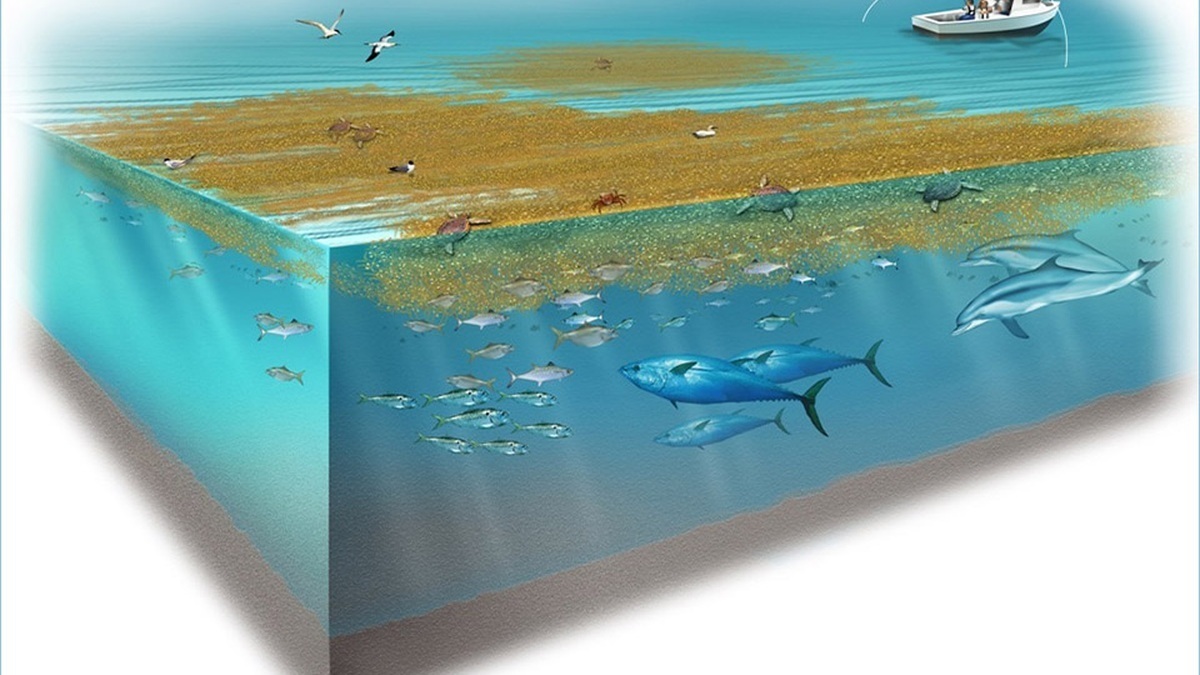
The Sargasso Sea is a region of the North Atlantic bounded by circulating currents rather than coastlines. It is named for floating brown algae called Sargassum, which forms patches and long weed lines at the surface. Its edges shift as the currents and atmosphere change.
The sea lies within the North Atlantic subtropical gyre. The Gulf Stream defines its western side, with the North Atlantic Current to the north, the Canary Current to the east and the North Equatorial Current toward the south.
The NOAA Sargasso Sea overview calls it the only sea without a land boundary. That phrase describes geographic definition, not a wall preventing water or animals from crossing.
Currents create a moving ocean region
Wind and Earth’s rotation drive the subtropical gyre. Surface water circulates clockwise across the basin and tends to converge toward the interior. Floating material can accumulate, though it continues to move within eddies and seasonal flows.
Current boundaries are broad transition zones rather than lines visible from a ship. The Azores High, seasonal winds and Gulf Stream meanders alter the region’s position and shape.
Water within the gyre is often warm, clear and nutrient-poor near the surface. Low nutrient supply limits plankton growth compared with upwelling zones, yet the ecosystem is not empty.
Holopelagic Sargassum never needs the seafloor
Two dominant forms, Sargassum natans and Sargassum fluitans, spend their whole life floating. They reproduce by fragmentation and vegetative growth rather than attaching to rock as many coastal seaweeds do.
Small gas-filled structures called pneumatocysts keep branches near sunlight. Leaf-like blades carry out photosynthesis, while tangled stems create a three-dimensional raft.
NOAA Ocean Exploration explains how floating Sargassum functions as habitat and later sinks when buoyancy is lost, carrying carbon to deeper food webs.
A mat is dynamic. Storms break it apart, currents merge patches and grazing animals remove tissue. Sargassum abundance varies widely across seasons and years.
Floating mats serve as nurseries
Juvenile sea turtles shelter and feed among the branches. Small crabs, shrimp and fishes use the structure, while predators patrol its edges. Several species have colors and shapes that camouflage them against the weed.
The sargassum fish can spend its life in this habitat. Commercial species such as mahi mahi and jacks also associate with weed lines, making Sargassum relevant to fisheries.
Habitat value depends on location and condition. A healthy offshore patch differs from a decomposing mass stranded in shallow water. Management should not treat all Sargassum as either beneficial or harmful.
Eels and migratory animals cross the region
European and American eels migrate toward the Sargasso Sea to spawn. Their transparent larvae travel on currents toward continental waters, where they grow before eventually beginning an ocean migration.
Humpback whales, tuna, sharks and seabirds pass through or feed within the region. The Sargasso Sea connects distant life cycles rather than containing a closed resident community.
NOAA Ocean Exploration describes the conservation importance of the Sargasso Sea, including eel spawning and porbeagle pupping habitat.
Migration makes protection difficult because threats occur across many national jurisdictions. An animal using the Sargasso Sea may spend most of its life elsewhere.
The Great Atlantic Sargassum Belt is different
Since 2011, enormous seasonal blooms have developed across the tropical Atlantic between West Africa, the Caribbean and Gulf. Scientists call this the Great Atlantic Sargassum Belt. It is not simply Sargasso Sea weed drifting south.
Nutrients, currents, winds and climate variability influence belt growth and transport. Satellite imagery tracks surface coverage, helping forecast arrivals months before the largest coastal inundations.
NOAA’s Sargassum from sea to shore guide separates productive offshore habitat from shoreline accumulations that can damage tourism and coastal environments.
Stranded Sargassum creates coastal problems
Thick piles shade seagrass and can trap hatchlings or small animals. As the weed decomposes, microbes consume oxygen and release hydrogen sulfide. The gas has a rotten-egg odor and can irritate people at sufficient exposure.
Removal is difficult because heavy equipment can erode beaches or disturb turtle nests. Collected biomass may contain salt, sand, arsenic or plastic, limiting uses in agriculture and products.
Forecasts allow communities to prepare equipment and choose sensitive collection methods. Offshore Sargassum should remain habitat, while material blocking a developed beach may require site-specific management.
Pollution accumulates within a current-bounded sea
Converging circulation can retain floating plastic alongside natural Sargassum. The North Atlantic garbage patch is diffuse, with small fragments spread across a huge area rather than a solid island.
Plastic can be eaten by wildlife or carry organisms across regions. Removing microscopic pieces from open water is impractical at scale, making prevention and waste control more effective.
The Sargasso Sea Commission coordinates stewardship for a region largely beyond national jurisdiction. Its work addresses shipping, fishing and pollution while recognizing the area’s moving boundaries.
A sea without shores still has ecological structure
The Sargasso Sea is defined by circulation, but its identity comes from biology as well as physics. Floating algae creates habitat within clear gyre water and migration routes link that habitat to continents.
Understanding the distinction between the Sargasso Sea and the tropical Sargassum belt prevents misleading explanations of beach strandings. Both involve the same genus of algae, yet they occupy different circulation systems and management contexts.
Scientists map a sea that has no fixed edge
Researchers use sea-surface height, temperature, salinity and current measurements to identify the gyre. Satellite-tracked drifters show actual water pathways, while numerical models fill gaps between observations.
A biological boundary may not match a physical one. Sargassum rafts cluster along fronts or eddies within the broader region and migrating animals cross current zones without recognizing a map line.
Dynamic boundaries require dates and methods. A study can define a polygon for sampling or governance, but it should not imply that the same water remains inside forever.
Long records distinguish seasonal movement from lasting circulation change. They also help interpret debris surveys because convergence varies with winds and eddy activity.
The region stores history in water and organisms
Oceanographers have repeatedly sampled the North Atlantic gyre, creating records of temperature, carbon and plankton. Comparison across decades reveals changes that a single expedition cannot detect.
Eel larvae, turtle tissue and Sargassum genetics provide biological evidence about movement and population connections. Each marker covers a different timescale and may be transported beyond the place where it formed.
The Sargasso Sea’s scientific value therefore extends beyond its famous weed. It is a long-term ocean observatory bounded by circulation, crossed by migrations and exposed to global pollutants.
Protecting that value requires coordinated monitoring across waters inside and outside national jurisdictions, because neither currents nor migratory animals stop at a political boundary.
Open-ocean governance crosses legal boundaries
Parts of the Sargasso Sea fall within Bermuda’s waters, while much of the region lies beyond national jurisdiction. Shipping and fishing are governed through different international bodies and treaties.
No single authority manages every activity. The Sargasso Sea Commission builds scientific cases and works with sector-specific organizations rather than acting as a coast-state government.
Conservation proposals need geographic definitions even though the physical sea moves. Boundaries can identify an area for action while management remains responsive to updated current and habitat data.
Vessel traffic, fishing pressure and plastic sources originate far outside the gyre. Cooperation with ports and markets may reduce impacts more effectively than enforcement only within a mapped polygon.
The sea demonstrates a broader challenge for open-ocean conservation: ecological connections are continuous, but law is divided by activity and jurisdiction.
Its name should not imply a motionless sea
Early sailors encountered floating weed and periods of weak wind, which helped create legends of trapped ships. The region still contains currents, eddies and storms and vessels are not physically held by Sargassum.
Historical reputation is best separated from present oceanography. The gyre moves water continuously even when local surface winds are calm, making the Sargasso Sea a circulating habitat rather than a stagnant pool.
Related reading: living shorelines and national marine sanctuaries.





