
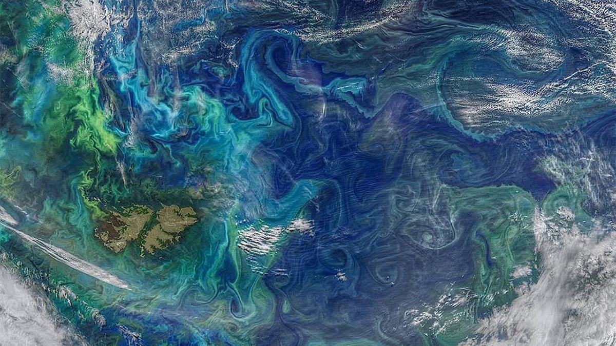
An ocean eddy is a rotating body of seawater that separates from, forms beside, or circulates within a larger current. Eddies range from small swirls near coasts to mesoscale features hundreds of kilometers across. They can last for days to months, carrying heat, salt, nutrients, plankton and floating material as they travel.
NOAA’s eddy definition calls an eddy a circular current of water. The motion resembles a weather system in some respects, but it occurs in the ocean and extends below the surface. A visible spiral of plankton may reveal an eddy, while many others are detected through sea-level measurements and drifting instruments.
How ocean eddies form
Strong currents rarely flow as perfectly straight ribbons. Meanders grow along their edges and a loop can pinch off into an independent rotating ring. The Gulf’s Loop Current and the Gulf Stream both shed large warm-core eddies. Elsewhere, flow around islands, abrupt seafloor features and collisions between water masses can generate rotation.
Differences in water density help sustain the structure. Temperature and salinity determine density, while Earth’s rotation influences moving water through the Coriolis effect. Pressure gradients balance the circular flow, allowing an eddy to persist after it separates from its parent current. Friction and mixing gradually drain its energy.
Wind can also inject energy into ocean circulation. Changes in wind stress curl the surface and encourage convergence or divergence. Coastal upwelling systems often develop filaments and eddies where cold water meets warmer offshore water. The resulting features exchange material between the continental shelf and the open sea.
Eddies are often called mesoscale because they occupy the middle ground between basin-wide currents and small turbulent motions. Typical mesoscale diameters span tens to hundreds of kilometers. Submesoscale eddies are smaller and shorter-lived, yet they can produce sharp fronts and vigorous vertical movement.
The seabed can anchor the location of recurring swirls without making each eddy permanent. Flow passing a headland or island may separate on the downstream side, while ridges redirect deep currents. Scientists distinguish a propagating ring from a locally forced circulation by tracking its center and examining how velocity changes with depth. A fixed instrument can record repeated passages, but a moving array is needed to follow one feature across open water.
Cyclonic and anticyclonic eddies
A cyclonic eddy rotates in the same sense as a large low-pressure weather system: counterclockwise in the Northern Hemisphere and clockwise in the Southern Hemisphere. Its surface often sits slightly lower than nearby water. Divergence near the center can draw colder, nutrient-rich water upward from below, producing a cold-core eddy.
An anticyclonic eddy rotates in the opposite direction. Surface water tends to converge toward its center and push the density layers downward. Many are warm-core rings with a slightly elevated sea surface. In the Northern Hemisphere they rotate clockwise; south of the equator they rotate counterclockwise.
Warm-core and cold-core eddies are useful descriptions, but regional context matters. An eddy may contain water warmer or cooler than its surroundings at a particular depth and its temperature signature can evolve. Scientists classify rotation from velocity and sea-surface height, then examine profiles to learn the internal structure.
NOAA researchers studying the Gulf documented anticyclonic features near Cuba and explained their connection to the Loop Current in an AOML research summary. Such regional eddies can affect pollution pathways and the transport of marine larvae. Their direction and position therefore have practical consequences.
What eddies carry through the ocean
An eddy can trap water from its formation region and transport that package across a different environment. Heat and salt move with it, altering local temperature and density. Plankton, fish larvae and dissolved chemicals may also remain partly enclosed. Leakage and mixing occur at the edges, so an eddy is a moving, imperfect container.
Vertical motion changes biology. Upward movement can bring nitrate and other nutrients into sunlit surface water, supporting phytoplankton growth when light is available. Downward movement can carry oxygen and organic carbon below. The exact response depends on the eddy’s type, age, season and the nutrient conditions it encounters.
Fronts around an eddy can concentrate floating organisms and debris. Predators may forage along these boundaries because prey gathers where currents converge. Larvae transported away from spawning grounds may reach new habitat or miss suitable nursery areas. One eddy can therefore connect distant ecosystems while isolating its core water for a time.
NASA satellite imagery of South Atlantic plankton shows colored swirls tracing currents and eddy edges. Ocean color reveals material carried by the water, not the velocity itself. Combining color with temperature and sea-level data produces a stronger interpretation than any single image.
Trapping is never complete. Water can cross an eddy boundary through filaments and small-scale stirring and organisms may swim across it. Researchers release drifters inside and outside a feature to measure retention directly. Comparing their paths reveals whether the apparent spiral acts as a coherent transport barrier or as a rapidly leaking swirl.
How satellites and floats detect eddies
Satellite altimeters measure tiny differences in sea-surface height. A raised or depressed patch can signal the pressure structure of an eddy. Repeated orbital measurements show the feature moving across a basin. Infrared sensors map sea-surface temperature, while ocean-color instruments reveal chlorophyll or suspended material that outlines circulation.
Clouds block infrared and visible sensors and surface patterns do not reveal the full depth. Autonomous profiling floats measure temperature and salinity below the surface. Drifting buoys follow currents, ship surveys collect high-resolution sections and moorings record change at fixed positions. Together they show the eddy’s three-dimensional structure.
Computer models blend observations with fluid dynamics to estimate currents between measurements. Forecast systems can track rings near shipping routes, offshore platforms, or storm paths. Model output carries uncertainty because small features and rapid changes may be missed. Operators compare several data streams before making a high-stakes decision.
Eddy kinetic energy describes motion associated with departures from the average current. It helps scientists map regions where circulation is especially variable. High values often occur near energetic western boundary currents and current confluences. The measure describes variability; it does not identify every circular feature by itself.
Why eddies affect weather and people
Warm eddies can store heat below the immediate surface. A tropical cyclone crossing one may churn up water that remains relatively warm, reducing the cooling that can otherwise limit intensification. Eddies are only one part of hurricane behavior and atmospheric conditions remain crucial. Ocean observations improve models by showing where deep warm layers exist.
For fisheries, eddies may move larvae and reorganize plankton while creating productive boundaries. Benefits vary by species and timing. An eddy that carries larvae toward nursery habitat can aid recruitment, while another route may carry them away. Fishers often notice temperature fronts, but scientific interpretation requires more than a single catch pattern.
Spill responders track eddies because rotating currents can redirect oil or debris and hold it within a region. Search-and-rescue planning faces the same challenge for drifting objects. Current forecasts use the feature’s evolving edge, not a static circle drawn from yesterday’s map. Continuous updates are important near fast-moving fronts.
Ocean eddies are therefore mobile engines of exchange. They transfer energy from major currents into smaller motions and move water properties across boundaries. Their rotation can be mapped from space, yet instruments in the water are needed to reveal depth. Understanding both views explains how a circular current influences a much larger ocean.
Related reading: surface and deep-ocean currents and measuring ocean currents.





