
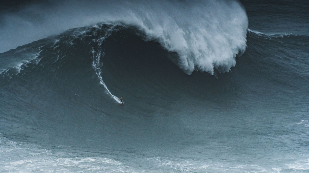
A rogue wave is an unusually large, steep wave that appears among much smaller surrounding waves. Oceanographers commonly use a threshold of more than twice the significant wave height, the average height of the highest one-third of waves in a measured record. The definition makes rogue waves relative to the sea state rather than dependent on one fixed height.
Such waves are real physical events, not maritime folklore. NOAA describes rogue waves as unpredictable and often arriving from a direction different from the prevailing wind or swell. Instruments on ships, platforms and buoys have recorded individual crests large enough to damage vessels that were designed for the expected conditions.
Most rogue waves last briefly. They form when energy becomes concentrated in one place through the interaction of ordinary waves, currents or nonlinear wave dynamics. The water then returns to the surrounding pattern, which helps explain why an enormous crest can seem to appear and vanish without a continuing wall of water.
A relative definition separates rogue waves from storms
Significant wave height summarizes a changing sea surface. It roughly matches the wave height an experienced observer might report and gives forecasters a practical measure of the dominant conditions. If significant height is four meters, a crest-to-trough wave exceeding eight meters meets the usual rogue threshold.
A ten-meter wave in a severe storm may therefore be large but ordinary for that storm. A six-meter wave amid two-meter seas can be rogue. The ratio captures the abrupt load change faced by a ship and avoids treating every tall storm wave as the same phenomenon.
Researchers also examine crest height above mean sea level and wave steepness. A very high crest can strike upper decks even when the trough is less extreme. Measurement choices matter because a buoy rises with the surface, a radar views a wider area and a ship sensor responds to vessel motion.
Ordinary waves can reinforce one another
The simplest mechanism is constructive interference. A sea contains waves with different periods and directions. When several crests overlap, their elevations temporarily add. Destructive interference follows when a crest meets a trough, so the exceptional height does not persist.
Random linear interference can produce rare extremes in a broad wave population. Storm seas provide many components that can combine and crossing swells increase the available directions. The probability is low for any one moment, yet the ocean supplies an enormous number of opportunities.
Some wave fields exchange energy through nonlinear interactions. Under suitable conditions, small changes grow and focus energy into a narrow group, a process often associated with modulational instability. Scientists continue to study how important this mechanism is outside controlled wave tanks because real oceans have changing winds and directional spread.
Refraction over seafloor features can also concentrate wave rays. An underwater bank or canyon bends different portions of a wave field, creating local hot spots. The effect is tied to geography, so models need accurate bathymetry to identify places where large waves may become more likely.
Currents can compress incoming swell
An opposing current slows the progress of wave energy while the period remains similar. Wavelength shortens and steepness rises, making waves higher and less stable. Strong current boundaries are especially important when swell travels against them.
The Agulhas Current off southern Africa is a well-known setting because large Southern Ocean waves can oppose a fast current. Other current systems and tidal inlets create related effects on smaller spatial scales. Current interaction is one route to a rogue wave, not a requirement for every event.
Winds can add energy at the same time and a crossing sea may place another swell on top of the compressed waves. Forecasting the combined state requires current speed, direction and wave spectra rather than a single height number.
The Draupner wave changed the evidence
On January 1, 1995, a laser instrument on the Draupner oil platform in the North Sea recorded an exceptional wave during a storm. The surrounding significant wave height was about 12 meters, while the measured wave reached roughly 26 meters from trough to crest. The record provided a clear instrumental example that could be analyzed in detail.
Earlier sailors had reported walls of water, but sparse measurements made individual accounts difficult to verify. The Draupner observation helped motivate better sensors and new statistical research. It did not prove one universal formation mechanism; it demonstrated that standard sea states can contain extremes beyond common design assumptions.
Satellite radar has since detected patterns consistent with very large waves across broad areas, though a satellite samples a location briefly. Buoys and platform instruments provide longer records at fixed points. Combining methods helps researchers estimate frequency without assuming every high reading is correct.
Why rogue waves threaten ships
A ship responds to both wave height and encounter angle. A steep wave striking the bow can send heavy green water over the deck. A beam-on impact can drive severe rolling, while a crest beneath the middle of a long hull may leave the bow and stern less supported. Structural loads can exceed those expected from the surrounding forecast.
Rogue waves are sometimes called killer waves, but not every encounter causes a disaster. Vessel size, speed and watertight integrity influence the outcome. Good routing reduces exposure to severe wave-current combinations, although the short-lived event itself cannot yet be predicted like a tide.
Marine forecasts from the National Weather Service report significant wave height, period and hazards. Mariners should remember that individual waves vary. NOAA guidance notes that larger individual crests occur within any sea, even when no rogue event develops.
Detection is improving faster than prediction
Modern directional buoys measure the full wave spectrum, showing how energy is distributed across periods and directions. Ship radar can map approaching crests over a limited area. Satellite altimeters add global observations, while numerical models combine winds, currents and bathymetry.
The National Data Buoy Center provides real-time observations that help verify forecasts. Longer archives reveal how frequently extreme ratios occur at different sites. Machine-learning tools are also being tested, but they depend on accurate observations and must distinguish dangerous focusing from ordinary statistical variation.
A reliable warning would need enough lead time for a ship to respond. Since a rogue crest may grow and decay within minutes, that goal remains difficult. The strongest current protection is broader: avoid severe sea states when possible, account for opposing currents and design vessels for rare loads beyond the average forecast.
Common claims need careful interpretation
A photograph of a tall wave beside a ship cannot establish the rogue ratio without a measured surrounding sea state. Perspective can exaggerate height and the ship may be in a trough. Instrument records provide stronger evidence than an isolated image.
Rogue waves are also distinct from tsunamis. A tsunami is a very long wave usually generated by sudden water displacement and can cross an ocean as a low surface rise. A rogue wave belongs to the wind-wave spectrum and is exceptional relative to nearby waves.
No single ocean region owns the phenomenon. Current boundaries can raise risk, yet constructive interference can occur elsewhere. Researchers discuss probabilities for particular conditions instead of marking permanent rogue-wave locations on a map.
The strongest evidence combines a calibrated sensor with a wave spectrum and environmental context. Such records let scientists test whether extreme crest height follows random statistics or points to a focusing mechanism.
How engineers account for rare extremes
Offshore design begins with long records and estimates of waves expected over a structure’s service life. Engineers calculate loads from extreme sea states, then consider individual crest statistics within those conditions. Safety factors address uncertainty that no record can remove.
Modern standards account for a crest striking decks above the normal waterline. They also examine slamming pressure, which can be far greater than a slowly applied load. Model tests and numerical simulations show how a specific hull or platform responds. After an accident, investigators need weather data, structural evidence and sensor records before assigning a rogue wave. The label should describe a measured extreme ratio, not serve as a catch-all explanation for any loss in heavy weather.
Related reading: Ocean floor topography explained and abiotic factors in the ocean.





