
The most famous lakes in the United States include the five Great Lakes, Lake Tahoe, Crater Lake, Great Salt Lake and several waters whose names are closely tied to national parks or major cities. Fame is subjective, so this list is an editorial selection based on geographic importance, cultural recognition, recreation, scientific interest and how often a lake represents its region. The numbering is an organizing device, not a scientific rank.
Natural lakes and human-made reservoirs both appear because Americans commonly encounter both as named lakes. Each entry identifies the type of water body so a reservoir is never mistaken for a natural lake. Readers interested in measured comparisons can also explore the largest lakes in North America, the clearest U.S. lakes and the states with the most lakes.
1. Lake Superior
Lake Superior is famous for its scale and its cold, storm-prone character. It is the largest freshwater lake in the world by surface area and its basin touches Minnesota, Wisconsin, Michigan and Ontario. The lake also anchors the identity of the North Shore, Isle Royale and the historic shipping route through the Great Lakes.
Superior holds more water than the other four Great Lakes combined, according to the U.S. Environmental Protection Agency’s Great Lakes figures. Its deepest point is about 1,333 feet, yet depth is only part of its reputation. Shipwrecks, long-distance freighters, lake-effect weather and largely forested shorelines give Superior a presence that extends far beyond a size table.
2. Lake Michigan
Lake Michigan is the only Great Lake located entirely within the United States. Chicago’s skyline rises from its southwestern shore, while Milwaukee, Green Bay and numerous beach towns face the same enormous body of water. Its connection to Lake Huron through the Straits of Mackinac makes the pair one hydrologic system at the same elevation.
The lake is equally well known for urban waterfronts and wild dunes. Indiana Dunes National Park protects a biologically rich stretch near heavy industry and Sleeping Bear Dunes National Lakeshore preserves towering sand formations farther north. Commercial navigation, drinking-water systems and recreation keep Lake Michigan embedded in daily life for millions of people.
3. Lake Huron
Lake Huron is recognizable for Georgian Bay, the Bruce Peninsula and a shoreline broken into countless channels and islands. Manitoulin Island, on the Canadian side, is the world’s largest island in a freshwater lake. In the United States, Michigan’s mitten-shaped Lower Peninsula meets Huron along its eastern edge.
The lake’s shallow reefs and busy nineteenth-century shipping lanes left a dense concentration of wrecks. NOAA’s Thunder Bay National Marine Sanctuary protects nearly 100 known shipwreck sites in U.S. waters, with more still undiscovered. That underwater record has made Huron a center for maritime archaeology as well as boating and fishing.
4. Lake Erie
Lake Erie is the shallowest Great Lake and the smallest by water volume. Those traits allow its water to warm quickly and make it highly productive for fish, but they also leave it responsive to nutrient pollution, harmful algal blooms and rapid weather changes. Cleveland, Toledo, Erie and Buffalo all sit along its shores or connecting waters.
Erie’s western basin receives heavy nutrient loads from the Maumee River watershed. Federal and state monitoring therefore makes the lake one of the country’s most closely watched freshwater systems. Its public image combines beaches, walleye fishing, industrial history and the continuing effort to control blooms without losing a major regional fishery.
5. Lake Ontario
Lake Ontario is the smallest Great Lake by surface area and the final lake in the chain before water enters the St. Lawrence River. Rochester lies on its U.S. shore, while Toronto faces it from Canada. Water arriving from the upper Great Lakes passes through the Niagara River and Niagara Falls before reaching Ontario.
The lake’s outlet made it strategically important for Indigenous travel, colonial trade and later international shipping. Today, the St. Lawrence Seaway links the Great Lakes with the Atlantic. Lake Ontario is also deep enough to retain cold-water habitat for trout and salmon, although its food web has been altered by invasive species and decades of fisheries management.
6. Lake Tahoe
Lake Tahoe straddles California and Nevada in the Sierra Nevada. It is famous for blue water, alpine scenery and a basin ringed by ski areas and public beaches. Tahoe is also the largest alpine lake in North America and one of the deepest lakes in the United States, with a maximum depth of about 1,645 feet.
Clarity has become the lake’s defining environmental issue. The EPA’s Lake Tahoe program describes how fine sediment and nutrients encourage algae and reduce transparency. Forest management, stormwater projects and limits on erosion all aim to protect the clear-water qualities that made Tahoe nationally recognizable.
7. Crater Lake
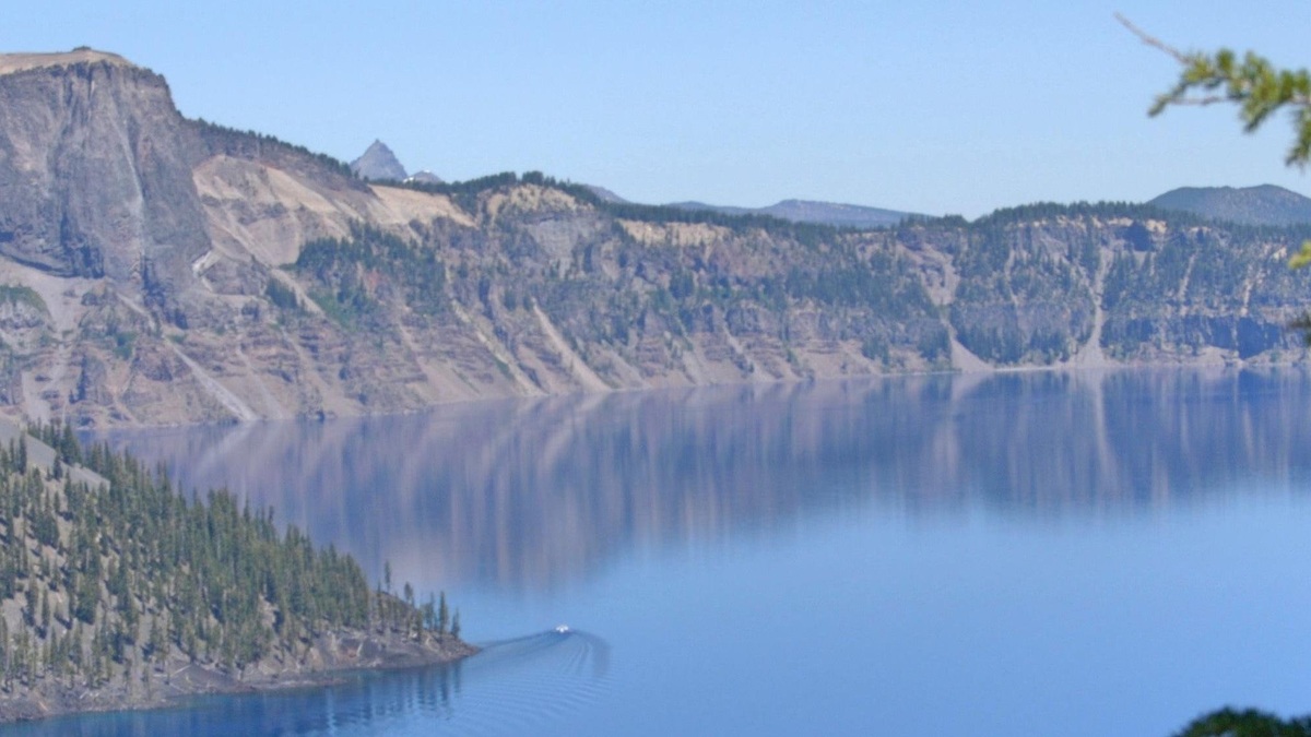
Crater Lake occupies a caldera created when Mount Mazama collapsed after a major eruption about 7,700 years ago. Rain and snow filled the basin, which has no incoming rivers. At 1,943 feet, it is the deepest lake in the United States, a distinction documented by the National Park Service’s Crater Lake profile.
The intense blue color comes from depth and exceptionally clear water rather than blue pigment. Wizard Island, a cinder cone rising above the surface, preserves evidence of volcanic activity after the collapse. Crater Lake’s near-circular outline and high caldera walls make its geologic origin visible at a glance.
8. Great Salt Lake
Utah’s Great Salt Lake is a remnant of prehistoric Lake Bonneville and the largest saline lake in the Western Hemisphere. It has no outlet to the ocean. Water leaves mainly through evaporation, while dissolved minerals remain behind and become concentrated. The lake’s surface area changes greatly as precipitation, river inflow and evaporation vary.
Although fish cannot live in its saltier main body, brine shrimp and brine flies support vast numbers of birds. The Utah Division of Wildlife Resources describes the lake as a critical feeding and resting place within western migration routes. Falling water levels can shrink habitat, increase salinity and expose dusty lakebed.
9. Yellowstone Lake
Yellowstone Lake lies high on the Yellowstone Plateau within the national park. It is North America’s largest high-elevation lake above 7,000 feet, with a broad surface underlain in part by the Yellowstone caldera. Hydrothermal vents, hot springs and underwater domes reveal that the volcanic system continues beneath the lake.
Native Yellowstone cutthroat trout connect the lake to the wider ecosystem because bears, birds and other predators feed on spawning fish. Introduced lake trout disrupted that relationship by consuming cutthroat trout in deep water. The National Park Service now treats suppression of invasive lake trout as a central conservation program.
10. Lake Champlain
Lake Champlain stretches between New York and Vermont, with a northern reach extending into Quebec. Its long, narrow basin follows a valley between the Adirondack and Green mountains. The lake served as a travel corridor long before European settlement and became a strategic route during the American Revolution and the War of 1812.
Modern Champlain is known for boating, lake-monster folklore and persistent water-quality work. The Lake Champlain Basin Program reports that the basin spans parts of New York, Vermont and Quebec. Phosphorus runoff and cyanobacteria blooms vary around the lake, especially among its distinct bays and segments.
11. Lake Okeechobee
Lake Okeechobee is Florida’s largest lake and the liquid center of a much larger water-management system. It is broad and shallow, with a natural tendency to spill southward into the Everglades. Dikes, canals and control structures now regulate much of that movement to serve flood control, water supply and agriculture.
The South Florida Water Management District tracks lake levels and operations because releases affect estuaries on both coasts as well as the Everglades. Okeechobee is also renowned for largemouth bass fishing. Its fame comes from being both an ecosystem and an engineered hub whose decisions ripple across South Florida.
12. Lake Mead
Lake Mead is a reservoir on the Colorado River, created by Hoover Dam rather than by a natural lake basin. Its coves occupy flooded desert canyons in Nevada and Arizona. For decades, the reservoir symbolized the scale of western water engineering and supplied storage for cities, farms and hydropower production.
Prolonged drought and heavy demand have exposed pale mineral bands on canyon walls, making water-level decline visually unmistakable. The National Park Service manages the surrounding recreation area, while the Bureau of Reclamation operates Hoover Dam and coordinates Colorado River water accounting.
13. Lake Powell
Lake Powell is another Colorado River reservoir, held behind Glen Canyon Dam along the Utah-Arizona border. Its branching arms fill side canyons in red sandstone country. Houseboats, Rainbow Bridge access and the contrast between blue water and pale cliffs made it one of the country’s most photographed reservoirs.
The reservoir also remains controversial because its creation inundated Glen Canyon and altered downstream flow, sediment and temperature. Glen Canyon National Recreation Area explains that Lake Powell’s level fluctuates with runoff and water releases. Low levels reveal former shorelines and complicate marina access while renewing debate about Colorado River storage.
14. Flathead Lake
Flathead Lake sits south of Glacier National Park in northwestern Montana. Glaciers excavated its basin and the Flathead River supplies much of its water. The lake is often described as the largest natural freshwater lake by surface area in the western United States outside Alaska, although definitions involving Tahoe and connected water bodies can change such comparisons.
Wild Horse Island, orchards along the eastern shore and views toward the Mission Mountains contribute to Flathead’s regional identity. Fisheries have changed after introduced lake trout and mysis shrimp reworked the food web. The lake remains important to the Confederated Salish and Kootenai Tribes, whose reservation includes the southern half.
15. Grand Lake
Grand Lake is Colorado’s largest and deepest natural lake, tucked beside Rocky Mountain National Park. A glacial basin created the natural lake, while twentieth-century engineering connected it operationally to Shadow Mountain Reservoir and the Colorado-Big Thompson Project. Water can pass through Grand Lake before crossing the Continental Divide in the Alva B. Adams Tunnel.
Northern Water lists a maximum depth of 265 feet, 515 surface acres and 4.5 miles of shoreline. Published depth figures vary, so the safest description emphasizes its official status as Colorado’s deepest natural water body. Grand Lake closes this editorial tour because its national-park setting and water-project role unite natural and engineered lake history.
More U.S. lake comparisons
Continue with 10 lakes near Reno, the 10 deepest lakes in Texas, the deepest lake in New England, Lake Minnetonka’s depth.
For a closer physical view, see Argo’s Lake Tahoe depth map and deepest-point guide.





