
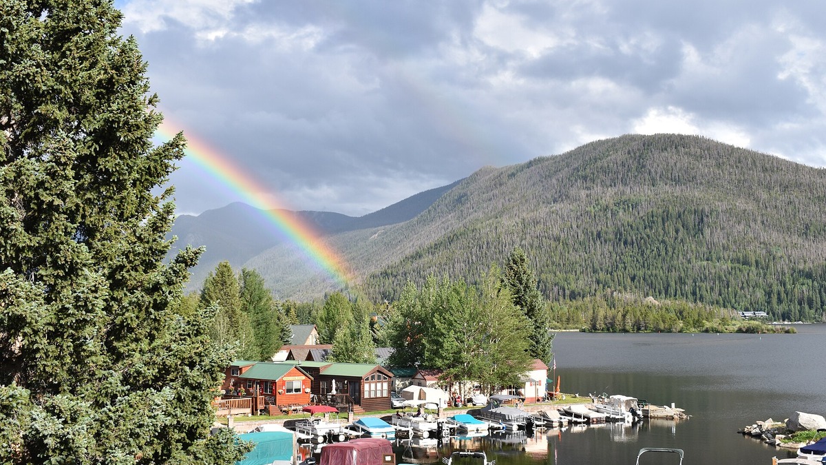
Grand Lake is the deepest natural lake in Colorado. Northern Water, the regional agency that operates the connected Colorado-Big Thompson system, gives its maximum depth as 265 feet. A U.S. Geological Survey inventory published an approximate depth of 250 feet, while 389 feet appears in many secondary references. The official figures therefore conflict and no single number should be presented without its source.
The most defensible short answer is Grand Lake, with an agency-reported maximum of about 265 feet and an older federal estimate of about 250 feet. The widely repeated 389-foot figure may derive from a different or poorly documented sounding, but a clear primary bathymetric record supporting it is difficult to trace. Grand Lake’s status is more secure than the exact depth attached to it.
Grand Lake is a natural lake
Grand Lake sits in Grand County near the western entrance to Rocky Mountain National Park. Glacial ice excavated its basin and a moraine helped impound water after the ice retreated. It is Colorado’s largest natural lake by surface area as well as the state’s deepest natural water body.
Northern Water lists 515 surface acres, 4.5 miles of shoreline and a capacity of 68,600 acre-feet. Those measurements describe different properties. Surface acres measure the water’s horizontal extent, acre-feet measure stored volume and maximum depth describes the deepest known point.
The lake’s surface lies around 8,367 feet above sea level. Elevation is not depth. A high mountain lake can be shallow, while a lower reservoir may have deep water near its dam. Grand Lake is notable because a deep glacial basin occurs at high elevation.
Why 265 feet is the clearest current agency figure
Northern Water is responsible for operations affecting Grand Lake and publishes 265 feet as the maximum. That figure equals about 81 meters. It appears with other specific physical data on the agency’s current lake page, making it the clearest readily available operational reference.
A value reported by an operator is still not a substitute for a modern bathymetric map with survey date, equipment, datum and uncertainty. Sonar resolution, the boat’s path and water-surface elevation can influence a maximum. The deepest sounding may also occupy a small depression that older transects missed.
Until a contemporary survey is published with full methods, “about 265 feet” communicates the current official figure without suggesting false precision. Converting it to 80.8 meters does not make the underlying measurement more exact.
The USGS reported about 250 feet
A 1980 U.S. Geological Survey inventory of Colorado lakes and reservoirs described Grand Lake’s maximum depth as approximately 250 feet. The same entry gave 480 acres of surface area and 60,000 acre-feet of storage, numbers that differ from Northern Water’s current page.
The word “approximately” is important. The USGS report compiled practical water-body information rather than presenting a new, high-resolution bathymetric survey for Grand Lake. Differences in lake level, mapping and rounding could account for part of the 15-foot gap between 250 and 265.
Both federal and regional values support the same broad description: Grand Lake has a maximum depth near 250 to 265 feet according to traceable agency sources. Neither one supports a claim that every contour of the basin is now known with foot-level accuracy.
Where the 389-foot figure fits
Many general references state that Grand Lake reaches 389 feet, or about 119 meters. Repetition alone does not identify the original measurement. Some pages attribute the figure vaguely to federal agencies without linking a specific survey, chart or report.
The 389-foot claim is substantially deeper than both the Northern Water and USGS values, so ordinary rounding cannot reconcile it. Possibilities include an old sounding, a below-sediment interpretation, a transposed number or a source copied through successive reference works. Without documentation, choosing among those explanations would be speculation.
A transparent account therefore reports all three published values and weighs their traceability. The 265-foot current agency figure and approximate 250-foot USGS figure have identifiable documents. The 389-foot figure is widespread but less securely sourced. A future modern bathymetric survey could resolve the discrepancy.
How Grand Lake formed
Pleistocene glaciers flowed through the upper Colorado River valley and eroded rock and sediment. Rocky Mountain National Park’s geology overview explains how glaciers carved valleys and left moraines across the region. When the ice withdrew, deposited debris and the basin’s bedrock geometry retained water.
Natural formation distinguishes Grand Lake from the large reservoirs nearby. Shadow Mountain Reservoir and Lake Granby were constructed as parts of the Colorado-Big Thompson Project. Their present basins and water levels depend on dams and project operations, although they occupy a landscape previously modified by ice and rivers.
Glacial origin does not automatically make a lake deep. Many Colorado tarns occupy shallow bedrock hollows. Grand Lake’s particular combination of erosion, valley form and impoundment created an unusually deep natural basin.
A natural lake inside an engineered system
Grand Lake existed long before the Colorado-Big Thompson Project, but it now functions within that engineered network. A channel connects it to Shadow Mountain Reservoir. Project water can move through the connected water bodies and then enter the Alva B. Adams Tunnel toward Colorado’s eastern slope.
The U.S. Bureau of Reclamation identifies Grand Lake as Colorado’s largest and deepest natural lake in its west-slope project information. Northern Water says operating criteria limit lake-level fluctuation to less than one vertical foot, partly preserving recreational and scenic conditions.
Connection to a reservoir does not convert Grand Lake’s origin into an artificial one. The lake remains a natural basin whose hydrology and water quality are now influenced by constructed channels, storage and transfers.
Grand Lake, Shadow Mountain and Granby
The U.S. Geological Survey calls Grand Lake, Shadow Mountain Reservoir and Lake Granby the Colorado Three Lakes System. Grand Lake lies upstream of the Adams Tunnel entrance, while Shadow Mountain provides a hydraulic connection toward Granby.
Water movement among the three can affect temperature, nutrients, algae and clarity. Grand County’s clarity program notes that project law includes preservation of Grand Lake’s scenic and recreational values. Monitoring often focuses on clarity because residents and visitors notice changes in the water’s appearance.
The system illustrates why lake labels need care. Grand Lake is natural, Shadow Mountain is a reservoir and Lake Granby is a reservoir. All three may appear as lakes on road maps, but their formation and management differ.
Does a reservoir beat Grand Lake?
The question “deepest lake” sometimes includes reservoirs and sometimes excludes them. Grand Lake is still commonly identified by federal and regional agencies as Colorado’s deepest natural lake. Reservoir depth figures vary with water level and may refer to water near a dam rather than a natural basin maximum.
Blue Mesa Reservoir is Colorado’s largest reservoir by capacity and surface area when full. Its dam rises 390 feet, according to the Bureau of Reclamation, but dam height is not identical to maximum water depth. Part of the structure can extend below the riverbed foundation and the reservoir surface fluctuates.
Dillon, Granby and other mountain reservoirs also have deep water, yet published figures require compatible definitions and dates before making an all-water-body ranking. The title’s conventional geographic answer remains Grand Lake, with the natural-lake qualifier stated plainly.
How maximum depth is measured
Modern bathymetry uses sonar to measure the interval between a transmitted sound pulse and its return from the bottom. Surveyors combine many soundings with precise positions, correct for sound speed and relate depths to a water-surface elevation or chart datum.
A single-beam instrument samples a narrow line below the boat. Multibeam sonar covers a wider swath and is more likely to locate a small deep pocket. Dense coverage also produces more reliable contours, volume estimates and habitat maps.
Soft sediment complicates interpretation because different frequencies may reflect from the sediment surface or penetrate it. A responsible survey documents equipment and processing. Without those details, two maximum-depth numbers can be compared but not fully explained.
What depth changes and what stays fixed
Water depth changes when the lake surface rises or falls. Sediment accumulation can also reduce depth over longer periods, while measurement technology can revise the mapped maximum without any physical change to the basin.
Grand Lake’s tightly managed surface limits ordinary fluctuation compared with many reservoirs. Even so, a depth should ideally include the lake level or datum used. A value rounded to the nearest five or fifteen feet already signals that the source was not claiming inch-level precision.
The identity of Grand Lake as Colorado’s deepest natural lake remains consistent across Northern Water and Reclamation descriptions. The unresolved part is whether its maximum should be quoted as about 250, 265 or the less traceable 389 feet.
Comparing Grand Lake with larger lakes
Grand Lake is small beside the Great Lakes, even though it is exceptional within Colorado. Lake Superior covers tens of thousands of square miles and reaches about 1,333 feet at its maximum. The Lake Superior depth overview provides a useful comparison of a well-charted continental lake.
Surface-area rankings tell a different story from depth. The largest lakes in North America dwarf Grand Lake horizontally, while some are shallower at their deepest point. Readers looking for a national discovery list can also browse 15 famous U.S. lakes.
The careful final answer is therefore concise: Grand Lake is Colorado’s deepest natural lake. Use about 265 feet when following the current operating agency, acknowledge the USGS estimate of about 250 feet and treat 389 feet as a widely published but presently hard-to-verify alternative rather than silently selecting it.





