NOAA’s latest assessment describes a climate pattern that is still gathering strength across the Pacific, leaving California’s coming winter surrounded by consequential questions. The agency gives El Niño a 97% chance of lasting into early spring 2027. It also sees an 81% chance that the event will become very strong during October through December 2026.
The scale of the forecast puts this event in rare territory. According to the NOAA Climate Prediction Center, a peak at the projected intensity would place it among the largest El Niño events in records extending back to 1950.
California could face an elevated chance of a wet winter, especially across the southern part of the state. The possible effects include intense rain, flash floods, landslides, coastal inundation and changes in marine ecosystems. Exact conditions will depend on the jet stream and the paths taken by individual storms.
NOAA raises the odds of a rare El Niño
In its July 9, 2026, diagnostic discussion, NOAA reported that El Niño had strengthened during the previous month. A broad region of the central and eastern equatorial Pacific was more than 1 degree Celsius warmer than average at the ocean surface.
The latest weekly value of the Niño-3.4 index reached 1.2 degrees Celsius above average. This index tracks sea surface temperatures in a key area of the equatorial Pacific. Farther east, the Niño-1+2 region had climbed to 2.7 degrees Celsius above average.
Warmth was also building beneath the surface. NOAA detected a downwelling Kelvin wave, a large pulse of warm water moving eastward below the equatorial Pacific. The wave deepened the thermocline, which is the boundary between warm surface water and colder deep water. That process helped raise temperatures in the eastern Pacific.
The agency summarized the trend in direct terms: “El Niño continues and will strengthen through the end of the year.” NOAA expects close interaction between the ocean and atmosphere to support the event into early 2027.
What makes an El Niño very strong
El Niño develops when unusually warm water spreads across the central and eastern tropical Pacific. That warmth changes where thunderstorms form over the ocean. The shifting storms then influence winds high in the atmosphere, which can alter weather patterns thousands of miles away.
Forecasters examine more than ocean temperature. They also track trade winds, air pressure, cloud formation and rainfall across the Pacific. In July, NOAA observed low-level westerly wind anomalies over the western and central equatorial Pacific. These winds can push warm water eastward and reinforce the warming already underway.
Upper-level winds were also behaving in a way associated with El Niño. Thunderstorm activity had increased over the central and east-central Pacific while decreasing around Indonesia. Together, these signals showed that the coupled ocean-atmosphere system was becoming more firmly established.
NOAA calls the highest intensity category a very strong El Niño. The popular phrase “super El Niño” often refers to the same broad idea. NOAA’s forecast states, “There is an 81% chance of a very strong El Niño during October-December.” If that forecast holds, the event “would rank among the largest El Niño events in the historical record going back to 1950.”
How strength changes the weather odds
A stronger El Niño exerts a larger influence on broad atmospheric circulation. This influence can make familiar seasonal patterns more likely, though every event develops within a different global weather background.
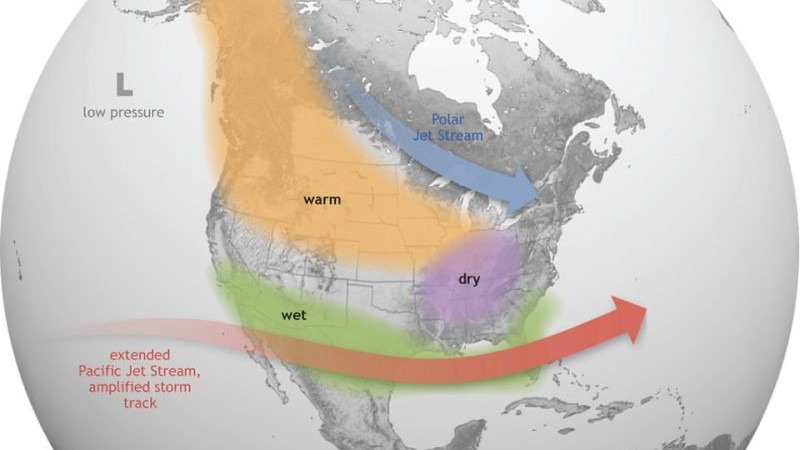
During a typical El Niño winter, the southern United States often experiences wetter conditions. Warmer and drier weather becomes more likely across parts of the northern United States and the Ohio Valley. The boundary between those patterns shifts according to the position and strength of the jet stream.
Event intensity helps forecasters adjust probabilities. As the Climate Prediction Center explains, “stronger events can more significantly tilt the odds in favor of expected outcomes.” That wording reflects the probabilistic nature of seasonal forecasting. A forecast describes which outcomes have gained or lost likelihood over several months.
Local terrain and storm timing still shape what residents experience. One California watershed may receive repeated heavy rain while another remains closer to average. A few powerful storms can also produce major impacts even when a season’s total rainfall appears less exceptional.
California’s winter rain and flood risks
For Southern California, the developing El Niño raises the probability of above-average winter precipitation. A more active southern storm track can steer Pacific weather systems toward the region. Heavy rain becomes especially hazardous when storms arrive close together.
Some of California’s strongest rainstorms take the form of an atmospheric river. These long corridors of water vapor can transport immense amounts of moisture from the Pacific. When that air rises over coastal mountains, it cools and releases rain or snow.
Successive storms can saturate hillsides and fill rivers quickly. Burn scars may be especially vulnerable because wildfire can remove vegetation and change the soil’s ability to absorb water. Intense rain over those landscapes can trigger debris flows with little warning.
Urban areas face a different set of pressures. Water can accumulate where storm drains become overwhelmed, while creeks and concrete channels can rise rapidly. Mountain regions may receive heavy snow if temperatures remain cold enough. Warmer storms can raise snow levels and send more water directly into rivers.
Coastal flooding and marine hazards
Along the coast, El Niño can contribute to higher sea levels for weeks or months. Warmer water expands and changes in winds and currents can push additional water toward the West Coast. Those conditions can amplify high-tide flooding when large tides and storm-driven waves arrive together.
Low-lying roads, beaches, harbors and coastal neighborhoods may see more frequent inundation. Erosion can accelerate when powerful waves strike shorelines already exposed to elevated water. Cliffs and bluffs can become unstable after repeated rainfall.
Changes beneath the ocean surface also matter. Past El Niño events have disrupted nutrient movement and shifted marine habitats along the West Coast. Fish and other animals may follow suitable temperatures into new areas, changing where predators and fishing fleets find them.
Harmful algal blooms have also thrived in West Coast waters during some previous El Niño periods. These blooms depend on several ingredients, including water temperature, nutrients, sunlight and circulation. El Niño can rearrange those conditions in ways that favor certain toxin-producing algae.
Why the jet stream matters
The jet stream is a fast-moving current of air several miles above Earth’s surface. It helps guide storms across the Pacific and North America. El Niño can strengthen and shift the subtropical branch of this atmospheric current.
When that branch extends toward California, storms may follow a more southerly route. This setup can increase the chance of wet conditions across the state’s southern half. A jet stream aimed farther north could direct the heaviest precipitation toward Northern California or the Pacific Northwest.
Small changes in the jet stream can produce large differences on the ground. Its shape evolves from week to week as weather systems interact across the hemisphere. Other influences include Arctic conditions, tropical thunderstorms outside the Pacific and patterns over the North Atlantic.
This sensitivity explains why El Niño provides useful seasonal guidance while leaving individual storms beyond the reach of a months-ahead forecast. Detailed predictions of rainfall amounts and storm locations become more reliable as each weather system approaches.
Forecast limits and the next update
NOAA’s probabilities come from observations, expert analysis and multiple computer models. The North American Multi-Model Ensemble projects further strengthening through 2026. Large stores of subsurface ocean heat and established atmospheric changes contribute to the agency’s high confidence.
Even so, the forecast will continue to evolve. The peak strength depends on how the trade winds behave, how much warm subsurface water reaches the eastern Pacific and how strongly the atmosphere responds. Tropical weather events can accelerate or interrupt those processes over relatively short periods.
California’s actual winter will also emerge storm by storm. Seasonal climate outlooks estimate broad patterns over large areas. Short-range weather forecasts will provide the detail needed to evaluate specific flood, snow, wind and coastal hazards.
The Climate Prediction Center scheduled its next ENSO diagnostic discussion for August 13, 2026. That update will show whether the Pacific remains on its projected path toward a historically strong event. For California, preparations for heavy rain and coastal flooding can begin well before forecasters know exactly where the most powerful storms will travel.