
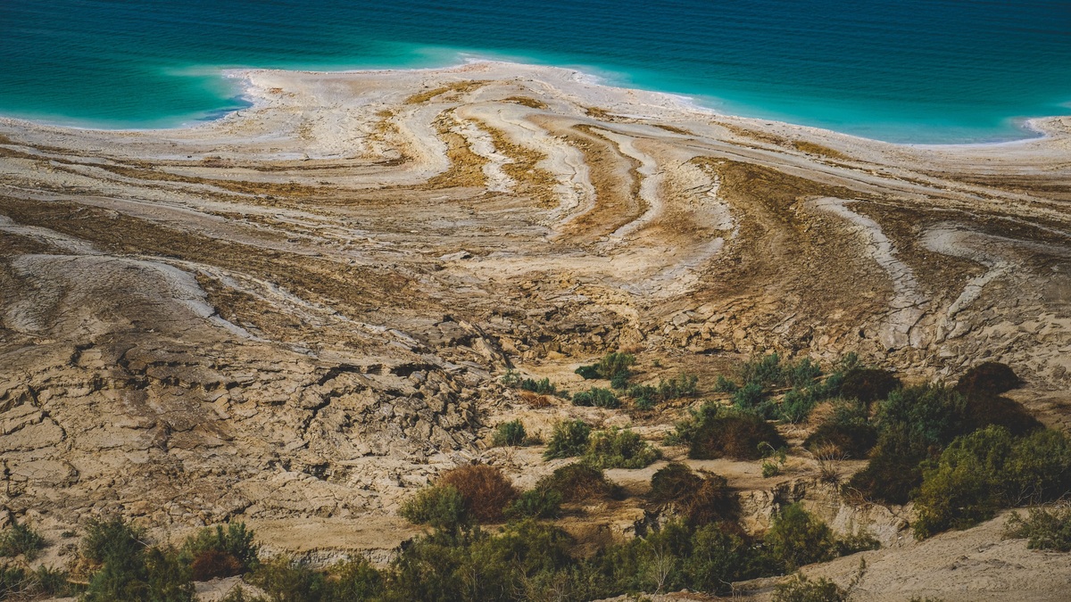
The Dead Sea shoreline is the lowest exposed natural land surface on Earth. Its water surface lies more than 430 meters, or about 1,410 feet, below mean sea level, although the exact elevation changes as the lake continues to fall. Any precise figure should therefore carry a measurement date and a stated datum.
The record category is an exposed continental surface. Ocean trenches extend thousands of meters below sea level beneath water, while mines or boreholes reach deeper below the ground. The Dead Sea claim concerns the elevation where land, water and air meet.
Where the Dead Sea sits
The lake occupies the Jordan Rift Valley between Jordan to the east and Israel and the West Bank to the west. NASA’s satellite view of the Dead Sea shows the narrow northern lake, salt works to the south and the steep terrain enclosing the basin.
The basin formed within the tectonically active Dead Sea Transform system, where the Arabian and African plates move past one another. Faulting created a deep structural depression. The lake surface fills only part of that depression and thick sediments extend beneath the present lakebed.
The Jordan River is the best-known inflow, joined by smaller wadis and groundwater. The Dead Sea has no natural surface outlet. Water leaves mainly by evaporation, so dissolved minerals remain and become concentrated.
How low is the shoreline?
NASA Earth Observatory reported a surface elevation around 435 meters below sea level for imagery acquired in 2019. The value should be treated as date-specific because levels have declined rapidly. Older references may say 400 meters or 430 meters and can have been broadly accurate when written.
“Below sea level” uses mean sea level as a vertical reference, although national surveys and scientific products may use different datums. Comparing two elevations requires the same reference system. Rounding to the nearest ten meters is safer in a timeless overview than presenting an undated decimal.
Lowest land is different from deepest water
The Dead Sea’s bottom lies hundreds of meters beneath its surface, but the deepest ocean floor is far lower in absolute elevation. Challenger Deep in the Mariana Trench approaches 11 kilometers below sea level. It is submerged seabed, so it belongs to a different record category.
Antarctica contains bedrock far below sea level beneath thick ice. That ground is neither exposed to the atmosphere nor a shoreline. Human excavations also create lower accessible points, but they are artificial. The Dead Sea record survives when the comparison is limited to naturally exposed land.
Elevation also differs from depth. Elevation measures a point relative to a datum; water depth measures the vertical distance from surface to bottom. A lake can have a very low surface without being the world’s deepest lake. Argo’s account of lake-size measurements shows why area, depth and elevation must be kept separate.
Why the Dead Sea keeps falling
Upstream diversion of Jordan River water for cities and agriculture has greatly reduced inflow. Mineral industries also pump brine into evaporation ponds. Natural evaporation remains intense in the hot, arid basin, leaving the lake with a sustained water deficit.
NASA’s Getting Saltier feature describes a decline of roughly 1.2 meters per year during the period it discusses. The annual rate varies, so it should not be multiplied forward as a guaranteed prediction. Direct gauge records provide the appropriate current figure.
As the shoreline retreats, groundwater dissolves buried salt layers and can trigger sinkholes. Roads, farms and tourism facilities built near the former shore face changing access and ground stability. The southern ponds visible in satellite images are industrial evaporation basins, not the continuous natural lake that once occupied that area.
Salt records need careful wording
The Dead Sea is hypersaline, with dissolved-salt concentrations around ten times those of average ocean water in many descriptions. Salinity varies by depth, location and date. Calling it simply “the saltiest lake” is unsafe because several Antarctic hypersaline lakes and smaller basins can exceed it. High salinity raises water density, helping swimmers float, but it does not make the water harmless. Swallowing concentrated brine is dangerous and splashes can irritate eyes or broken skin. The lake supports microbial life despite conditions that exclude fish and most familiar aquatic organisms.
Readers comparing saline systems can see Argo’s Great Salt Lake groundwater story and global freshwater distribution. Closed-basin lakes share evaporation-driven concentration, yet their chemistry and water balances are not interchangeable.
How to state the record accurately
A careful sentence says: “The Dead Sea shoreline is Earth’s lowest exposed natural land surface, currently more than 430 meters below mean sea level.” Add a year when giving a narrower figure. Avoid implying that the shoreline is fixed or that the lake’s bottom is Earth’s deepest point.
The lowest shoreline point moves as the lake recedes. A newly exposed strip of land inherits the current water-surface elevation, while an older benchmark may sit higher above the water. The geographic record remains at the Dead Sea even though its precise contour changes.
Satellite imagery is especially helpful because it records both position and date. NASA’s archive includes a 1999 Landsat image, allowing readers to compare an earlier extent with newer observations. Image footprints and water classifications still need their metadata.
The record combines geology with a fast-changing water balance. Faulting created the low basin, while inflow loss and evaporation continue to lower the surface. Preserving the words exposed, natural, elevation and date keeps the claim scientifically defensible.
Satellite images reveal the shrinking outline
Landsat records let researchers compare the lake using consistent overhead observations across decades. The northern basin remains the principal natural water body, while the southern area is divided into geometric industrial ponds. A color satellite image distinguishes open water from salt pans, but extracting shoreline elevation requires georeferenced analysis and gauge data.
Seasonal differences should not be confused with the long decline. Image dates, sensor names and processing choices belong with any side-by-side comparison. A wet-season scene may show darker water or temporary flooded margins without reversing the multidecadal loss.
The falling level also changes map labels. Facilities once described as lakeside can end up far from the water and former peninsulas may connect to land. A modern map must distinguish the current northern lake from evaporation ponds that retain the historical name in tourism graphics.
The basin’s depth comes from tectonics
The Dead Sea Transform is a strike-slip plate boundary, meaning much of the motion is horizontal. Bends and stepovers in such fault systems can create subsiding basins. Sediment carried into the depression has accumulated over geological time, recording changes in lake level and regional climate.
Surface elevation reflects both the deep tectonic depression and the amount of water currently stored. Fault motion created room for a low lake, while the modern water deficit determines where within that basin the surface sits today. The two mechanisms operate on very different timescales.
Hydrologic losses dominate the modern shoreline retreat, while tectonic subsidence operates on a different timescale. Geological structure explains the location of the basin and its extraordinary absolute elevation.
Compare elevations with consistent conventions
Historical USGS measurements may be reported as positive “meters below sea level” or as negative elevations. A shoreline 435 meters below sea level can be written as −435 meters elevation. Mixing those conventions can reverse a trend on a chart, so the axis label and sign must be retained.
Comparisons with other low places should use exposed natural ground measured against a compatible mean-sea-level reference. Badwater Basin in Death Valley is the lowest point in North America, but it sits far higher than the Dead Sea shore. The Dead Sea holds the global exposed-land record because its rift basin descends much farther.
The NASA Earth Observatory image record provides a date-stamped visual reference for the modern shoreline. Using it alongside gauge measurements preserves both location and time, which an undated atlas figure cannot do.





