
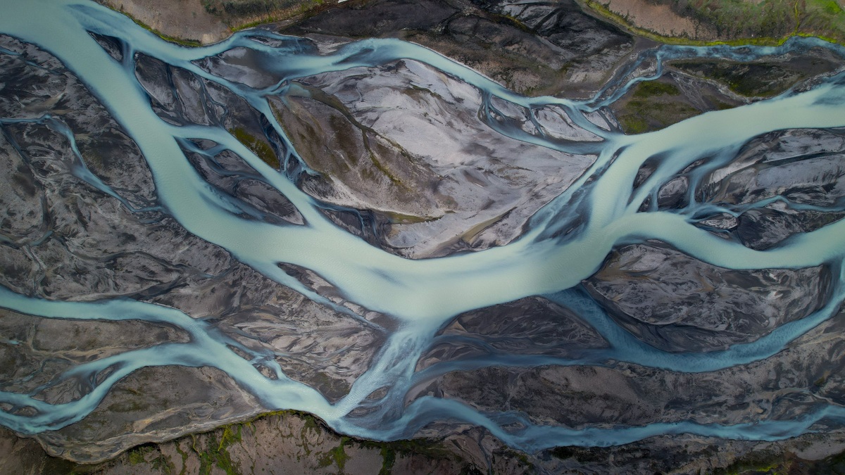
A braided river splits into several shifting channels around bars or islands, while a meandering river follows one main channel through a sequence of bends. Both patterns move water and sediment downstream. Their different shapes arise from the balance among flow, sediment supply, valley slope and the resistance of the bed and banks.
The contrast is easiest to see from above. Braided rivers resemble loose strands that divide and reunite. Meandering rivers trace broad loops across a floodplain. A river can display both patterns in different reaches or change from one to the other as its sediment load, discharge or bank vegetation changes.
Braided channels divide around sediment bars
Braiding begins when a river deposits enough sediment within its channel to form bars. Flow separates around the obstruction, concentrating water into neighboring paths. Continued deposition can raise the bar above ordinary water level, while the flanking channels deepen or migrate.
The classic USGS study of braided, meandering and straight channels described braiding as a quasi-equilibrium adjustment among discharge, load and transporting ability. It cautioned against treating every braid as proof that a river simply carries too much total sediment. Grain size and slope influence the pattern, as does the ease with which banks erode.
Braided reaches are common where sediment arrives in pulses and banks offer little resistance. Glacial outwash plains provide a familiar setting because meltwater supplies sand and gravel across wide valleys. Mountain fronts and volcanic landscapes can develop similar networks, particularly below rapidly eroding terrain.
Meanders grow through erosion and deposition
Water moves faster along the outside of a bend and more slowly near the inside. The outer bank tends to erode, forming a cut bank, while sand or gravel accumulates on the inner bank as a point bar. Those paired processes move a bend sideways and downstream over time.
A meandering channel is usually associated with a lower slope and more cohesive banks than a braided reach carrying comparable flow. Vegetation strengthens many riverbanks with roots and also slows water near the edge. Silt and clay provide cohesion that loose gravel lacks, helping one channel remain distinct even as its bends migrate.
Meanders are one part of the wider set of landforms created by rivers. Continued migration builds floodplains and leaves curved scars. A river may eventually cut across a narrow meander neck. The abandoned loop may become an oxbow lake if sediment seals its connections to the active channel.
Slope, sediment and banks set the pattern
No single measurement separates every braided river from every meandering one. Braiding is favored by a combination of relatively steep gradient, readily moved bed material, variable discharge and erodible banks. Meandering becomes more likely where a stable single channel can transport its load without repeatedly dividing.
Sediment size changes how the bed responds. Coarse grains require stronger flow to move, then settle quickly when local velocity falls. Fine suspended material can travel farther and may add cohesion when it is deposited on banks or floodplains. A river carrying a mixture continually sorts the load as depth and velocity change.
Discharge also varies from season to season. Snowmelt rivers can spread across bars during high flow and retreat into a few narrow threads later. A channel map made in one month may exaggerate or hide some of that activity, so geomorphologists combine imagery with field evidence and records of flow.
Why braided channels shift so quickly
Each bar redirects flow toward another part of the channel belt. Erosion in the new path supplies more sediment. Some of that material settles downstream, where it can create another division. The active threads can migrate between floods, leaving islands that range from bare gravel to vegetated surfaces stable for years.
Rapid movement makes infrastructure difficult to place. A bridge designed around the deepest channel may face a different alignment after a major flood. Embankments that confine the river can increase velocity or transfer erosion downstream. Effective design has to consider the full active channel belt rather than the thread carrying the most water during a site visit.
Why meandering rivers keep moving
A meander may look stable on a human time scale, yet its banks record steady adjustment. Flow spirals through bends. Near-surface water moves toward the outer bank, while part of the return flow follows the bed. The resulting pattern helps erode one side while carrying sediment toward the point bar.
Channel migration rates vary widely. Resistant bedrock can pin a bend, while a river in loose floodplain sediment may move several meters during a flood. The USGS study of a Wabash River point bar shows how channel migration, flow and deposition leave organized layers within the bar.
Cutoffs shorten the river and steepen the local water-surface slope. The channel then adjusts its bed and neighboring bends. Oxbow lakes preserve the former route. Fine sediment and organic material gradually accumulate after direct flow stops.
Rivers can switch between patterns
A river’s planform responds to changes across its drainage basin. Removing bank vegetation may lower resistance to erosion. A dam can reduce floods and trap sediment, while gravel mining alters the bed. Landslides or wildfire can deliver a sudden sediment pulse that encourages bar growth downstream.
Natural transitions also occur along one river. A confined mountain reach may open onto a broad valley and begin to braid as slope and sediment conditions change. Farther downstream, more resistant banks may support a single meandering channel where the gradient is gentler. Argo’s overview of major rivers and drainage basins provides the larger geographic setting for such downstream changes.
How to identify the two river types
Start with a sufficiently long reach rather than one bend or one island. A braided reach contains multiple active channels separated by exposed or vegetated bars and those channels repeatedly divide and rejoin. A meandering reach has one dominant channel with alternating bends and point bars.
Aerial images from different years reveal whether bars, bends and entire channel threads are moving. Field evidence adds grain size and bank material. Surveyed floodplain height provides further context. Flow records show whether the apparent pattern was photographed during unusually high or low water.
Labels describe the dominant planform, not an unchanging identity. Braided rivers can contain curved threads and meandering rivers can split around an island. The useful distinction lies in how the reach organizes most of its flow and how that organization responds to sediment and bank resistance.
Why river restoration must respect channel pattern
Restoration plans sometimes aim for a visually tidy single channel even where sediment and flow favor braiding. Confining such a river can raise velocities and concentrate erosion against levees. At a naturally meandering site, straightening shortens the route, increases slope and often triggers bed incision or renewed bend formation downstream.
The EPA’s CADDIS guidance on physical habitat treats channel form as one part of a connected system that includes flow, sediment and riparian conditions. A reference reach from the same valley setting provides stronger guidance than a generic ideal drawn from another river type.
Designers also need the historical range of movement. Old aerial photographs and abandoned channels reveal the space a river has occupied during past floods. Allowing room for bars or migrating bends can protect the geomorphic processes that maintain habitat, whereas a fixed corridor may require repeated engineering to resist the pattern the river naturally rebuilds.
Monitoring after construction tests whether the design follows the intended trajectory. Cross sections record bed elevation, while repeat images locate bars. Vegetation surveys separately show whether islands are stabilizing. If sediment begins accumulating where a bridge opening is narrowest, an early adjustment is safer than waiting for the next large flood to expose the mismatch.





