
Geologists classify estuaries into four major types according to how their basins formed: drowned river valleys, bar-built estuaries, tectonic estuaries and fjords. The shape inherited from sea-level rise, sediment movement, crustal motion or glaciers influences every later tide and current.
The system describes origin rather than present-day water circulation. A fjord can behave like a strongly layered basin, while another glacial estuary may mix more freely. The same estuary can therefore receive one geologic label and a different circulation label.
NOAA’s estuary geology classification lists these four types and notes that most modern estuaries are younger than 10,000 years. Many developed as melting ice raised sea level near the end of the last glacial period.
1. Drowned river valley estuaries
A drowned river valley forms when rising seawater floods a preexisting river valley. The river once cut its channel across exposed land. As sea level rose, the lower valley filled with salt water and became a long coastal inlet with freshwater entering at its head. These estuaries are also called coastal plain estuaries. Their cross sections tend to be broad and relatively shallow compared with fjords. Tributary valleys become side embayments, creating a branching outline that preserves the old drainage network.
The Chesapeake Bay is a prominent example. NOAA identifies Coos Estuary in Oregon, the Hudson River and Narragansett Bay as others. Outside North America, the Thames and Seine occupy drowned valleys.
River flow and tides determine how salt moves through the flooded channel. Dense seawater can travel landward near the bottom while fresher river water moves seaward above it. Channel depth and tidal energy decide whether the estuary develops a salt wedge or a more thoroughly mixed profile.
Sediment gradually alters the inherited shape. Rivers deliver sediment that marshes can trap, while currents redistribute the remaining material across shoals. Sea-level rise creates space for deposition. Dredging changes the basin differently by deepening channels that may allow salt to move farther upstream. The drowned-valley label therefore identifies the original container rather than a frozen landscape. Erosion continues to change water depth alongside wetland growth and engineering. Researchers reconstruct older channels beneath bay sediment to distinguish the flooded river network from deposits that accumulated after inundation.
2. Bar-built estuaries
A bar-built estuary lies behind a coastal sediment barrier deposited roughly parallel to shore. The barrier may appear as a beach or extend into an island with a lagoon behind it. Waves and alongshore currents move the sediment, while one or more inlets connect the protected basin to the ocean.
The restricted mouth controls exchange. A narrow inlet can reduce tidal range inside the estuary and lengthen the time water remains there. Storms may widen or relocate the opening, while quiet periods allow sand to accumulate and partly close it. Inlet stability depends on the balance between tidal flow and the sediment delivered alongshore. When the opening becomes too small, faster currents may scour it deeper during the next strong tide.
NOAA lists Pamlico Sound in North Carolina, Matagorda Bay in Texas and the Nauset barrier system on Cape Cod as examples. Bar-built estuaries are common on low-gradient coasts where sediment is abundant and waves can build persistent barriers.
Freshwater flow is often modest or seasonal. During heavy rainfall, a river may cut through a bar and reopen the mouth. Drought and wave-driven deposition can close it again, producing large salinity changes within the lagoon.
Barrier islands absorb wave energy and protect marshes behind them, but they move as sea level and sediment supply change. Development that fixes the barrier in place or interrupts sand transport can alter both the inlet and the estuary it encloses. Inlet location controls which part of the lagoon receives the strongest marine exchange. When an inlet migrates, old channels may fill and new tidal deltas form. These adjustments can change navigation depth and salinity even though the estuary remains bar-built.
3. Tectonic estuaries
Tectonic estuaries occupy depressions created by movement of Earth’s crust. Faulting or subsidence lowers land below sea level, allowing marine water to enter. Rivers draining the surrounding landscape then bring fresh water into the new basin. San Francisco Bay is the classic example in NOAA’s tutorial. Its basin developed in a region of active faults and later flooded as sea level rose. The modern estuary connects the Sacramento-San Joaquin river system with the Pacific through the Golden Gate. Several connected sub-basins record a complicated history rather than one simple crack in the crust.
Tectonic origin does not mean the basin keeps changing dramatically from day to day. The relevant crustal movement may unfold over centuries or much longer. Earthquakes can alter elevation suddenly. Steady crustal motion instead adjusts shorelines gradually and redirects drainage over time.
The shape can be irregular because faults and subsiding blocks define its margins. Narrow connections may accelerate tides, while broad embayments store water. Those features influence sediment deposition and the location of wetlands.
Researchers distinguish tectonic formation from later modifications. Sediment can partly fill the depression, while a river may build a delta into it. People sometimes reclaim the remaining shallow margins. The geologic label identifies the basin’s primary origin even after these processes reshape it. Evidence for tectonic origin comes from faults and subsided blocks visible in the regional rock structure. Seismic records help establish timing alongside sediment cores. Rising postglacial seas may complete the flooding, but the crustal depression supplied the basin that received the water. Researchers compare the ages of drowned deposits with fault movement to reconstruct that sequence.
4. Fjord estuaries
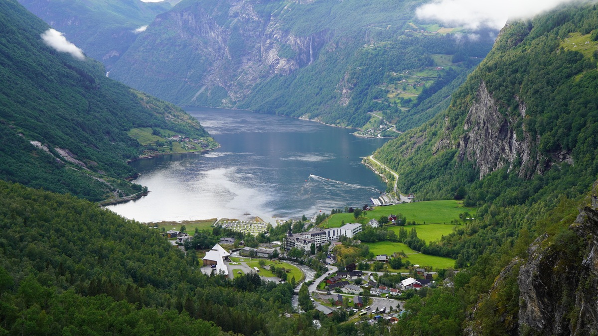
Fjords begin as valleys carved by glaciers. Moving ice deepens and widens the rock beneath it, often excavating the inner valley more strongly than the area near the coast. When the glacier retreats and the sea enters, it leaves a long narrow inlet with steep walls.
A shallow ridge near the mouth is called a fjord sill. It may consist of bedrock or glacial debris. The sill limits exchange between deep fjord water and the open ocean, while surface water can pass over it more readily. Sonar mapping reveals whether the sill contains narrow channels that allow episodic deep inflows.
Restricted deep exchange can allow bottom water to lose oxygen. Dense seawater may renew it only during occasional inflow events that cross the sill. Offshore density determines whether the water can cross, while wind and freshwater discharge modify the opportunity for inflow. Sediment cores from oxygen-poor basins can preserve layered records that are disturbed less by bottom-dwelling animals.
Fjords occur along formerly glaciated coasts in Norway, Alaska and Greenland. NOAA also points to Glacier Bay and the Georgia Basin region of Puget Sound. Chile and New Zealand contain extensive fjord landscapes as well.
The steep terrain funnels rivers and snowmelt into a confined surface area, often creating a fresh upper layer. A fjord may therefore be strongly stratified, yet geology alone does not guarantee one circulation pattern. Sill depth sets the deep-water connection. Tides control mixing at the mouth, while freshwater input influences the surface layer. Glacial erosion can leave several deep basins separated by inner sills. Water renewal may differ from one basin to the next, producing sharp oxygen contrasts within the same fjord. Mapping the submerged rock profile is therefore essential to explaining present circulation. The map can also reveal sediment-filled troughs that preserve the path of former ice. Combined with rock samples and dated sediments, the submerged terrain shows which features glaciers excavated and which developed after seawater entered. That history separates a true fjord from a steep coastal valley produced mainly by other erosion.
Related reading: the difference between an ocean and a sea and how saltwater lakes form. Authoritative background: NOAA explains what defines an estuary, while the EPA outlines estuary habitats and functions.





