
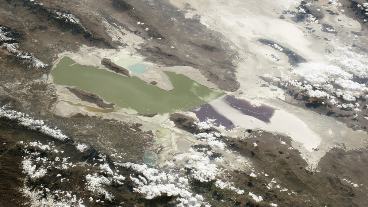
Utah’s biggest lake is the Great Salt Lake, which covers about 1,700 square miles at its approximate historical-average elevation of 4,200 feet. Its broad, shallow basin makes the shoreline unusually mobile. The lake covered less than 1,000 square miles in 2022, while its 1986 high spread across roughly 2,300 square miles, according to the U.S. Geological Survey.
The state also contains large freshwater lakes and reservoirs. Lake Powell, Utah Lake, Bear Lake and Flaming Gorge Reservoir give the top of the ranking a mix of natural and human-made waters. Their combined scale explains why a list of the major lakes of Utah reaches far beyond the state’s famous salt lake.
Surface area measures the water’s footprint. Depth and volume are separate measurements. Readers comparing Utah with the continent’s biggest waters can also see the largest lakes in North America. The Great Lakes occupy a different geological setting, described in how the Great Lakes formed.
How the lakes were ranked
This list ranks named lakes and reservoirs by commonly cited surface area at a conventional, normal or full pool. The full area is counted for Bear Lake, Lake Powell and Flaming Gorge Reservoir because each crosses Utah’s boundary and has a substantial Utah section. The complete-water approach makes lake size the basis of every comparison.
Great Salt Lake uses the historical-average figure of 1,700 square miles because it has no fixed full pool. Reservoir figures describe designed or full conditions, so their actual areas can shrink during drawdowns.
1. Great Salt Lake, about 1,700 square miles
Great Salt Lake occupies a closed basin in northern Utah. Rivers carry dissolved minerals into the lake, then evaporation removes water and leaves the salts behind. At the historical-average elevation used here, the lake spans about 1,088,000 acres. The Utah Geological Survey gives a closely related estimate of 1,034,000 acres at an elevation near 4,200 feet, showing how the chosen elevation and mapping method affect the result.
Shallow water drives the enormous changes in area. A small vertical drop can uncover miles of lakebed, raising concerns about dust and shrinking habitat. The lake has no outlet to the ocean. Water leaves mainly through evaporation, while the Bear, Weber and Jordan rivers replenish it. A railroad causeway divides the north and south arms, limiting circulation and helping produce different salinity levels. Brine shrimp and vast wetland complexes support millions of migrating birds along the Pacific Flyway.
2. Lake Powell, 161,390 acres
Lake Powell covers 161,390 acres, or about 252 square miles, at its normal water-surface elevation. The Bureau of Reclamation lists a length of 186 miles at that level. Glen Canyon Dam holds back the Colorado River, filling a branching network of former river canyons in Utah and Arizona.
Most of the long upper reservoir lies in Utah, while the dam stands just across the Arizona line. Drought and water releases can expose broad bands of pale rock along the shore, so the actual footprint often falls below the design figure. Its narrow side canyons also produce far more shoreline than a round lake of similar area. Reclamation balances storage with downstream deliveries and power generation at Glen Canyon Dam, making reservoir elevation an important measure across the Colorado River Basin.
3. Utah Lake, about 96,000 acres
Utah Lake covers about 96,000 acres, equal to 150 square miles. A Utah State Parks resource plan describes the lake as broad and shallow, with an average depth of roughly 9.2 feet. It is Utah’s largest freshwater lake lying entirely within the state.
The Provo River supplies much of its inflow and water exits through the Jordan River toward Great Salt Lake. Wind-driven waves can stir fine bottom sediment because the water is shallow. Utah Lake’s legal compromise elevation controls how water storage and releases are managed, which also influences the shoreline position.
4. Bear Lake, about 112 square miles
Bear Lake straddles Utah and Idaho and covers about 112 square miles, or 71,680 acres, at an elevation of 5,923 feet. Utah State Parks reports that it extends about 20 miles from north to south and reaches 208 feet deep. Slightly more than half of the lake lies in Utah.
Earthquake movement helped form the basin and calcium carbonate particles contribute to the water’s blue-green color. Bear Lake is natural, although its upper levels are managed for water storage through canals connected to the Bear River. Four native fish species occur nowhere else, giving the lake ecological importance beyond its size.
5. Flaming Gorge Reservoir, 42,020 acres
Flaming Gorge Reservoir has a normal surface area of 42,020 acres, or nearly 66 square miles. The Bureau of Reclamation records a total capacity of 3,788,900 acre-feet. Flaming Gorge Dam impounds the Green River in northeastern Utah, while the reservoir reaches north into Wyoming.
Steep canyon walls border parts of the Utah section, with broader water farther upstream. Storage and power operations cause the level to fluctuate. Releases below the dam also affect river temperature and habitat through a reach valued for its trout fishery.
6. Strawberry Reservoir, about 17,160 acres
Strawberry Reservoir covers about 17,160 acres, close to 27 square miles, at maximum capacity. The Bureau of Reclamation explains that Soldier Creek Dam enlarged the earlier reservoir, roughly doubling its original surface area. The expanded system can store more than 1.1 million acre-feet.
The reservoir lies east of the Wasatch Range at an elevation near 7,600 feet. It captures water in the Uinta Basin and tunnels move part of that supply west toward farms and communities in the Bonneville Basin. Strawberry is also one of Utah’s best-known sport fisheries, supported by intensive fish and habitat management.
7. Sevier Bridge Reservoir, 10,905 acres
Sevier Bridge Reservoir, widely called Yuba Reservoir, has a cited surface area of 10,905 acres, or about 17 square miles. The figure appears in the Yuba State Park resource management plan. The long reservoir occupies the Sevier River valley in Juab and Sanpete counties.
Irrigation withdrawals and uneven runoff produce substantial seasonal changes. Beaches expand when the water recedes and boat access can shift with the pool. Its official name comes from Sevier Bridge Dam, while the familiar Yuba name traces to the people who built the structure. Regional comparisons can continue with the planned list of the largest lakes in Nebraska.
8. Willard Bay Reservoir, about 9,200 acres
Willard Bay covers approximately 9,200 acres, or a little more than 14 square miles, when full. The federal recreation portal Recreation.gov identifies Reclamation as the reservoir manager. Dikes completed in the 1960s separated this freshwater storage pool from the northeastern edge of Great Salt Lake.
The reservoir stores water diverted from the Weber River system for farms and growing communities along the Wasatch Front. Its lowland location and shallow profile give it a different character from Utah’s high mountain reservoirs. State parks manages recreation under an agreement with Reclamation.
9. Cutler Reservoir, 7,184 acres
Cutler Reservoir reaches a maximum surface area of about 7,184 acres, or 11.2 square miles. A Utah Division of Water Rights hydrology report calls it the largest reservoir by surface area in Cache Valley. The Bear River, Logan River and Little Bear River feed its shallow, branching waters.
Cutler averages only about three feet deep in the cited report, which explains how it can cover so much land while storing less water than several smaller reservoirs. PacifiCorp operates the dam for hydroelectric generation and temporary flow regulation. Wetlands and open water around the reservoir also provide important bird habitat.
10. Starvation Reservoir, about 3,300 acres
Starvation Reservoir covers about 3,300 acres, or 5.2 square miles, when full. A joint state and federal resource management plan gives the maximum surface area and a capacity of about 167,000 acre-feet. The dam stands on the Strawberry River northwest of Duchesne.
Winter and spring flows from the Strawberry and Duchesne river systems fill the reservoir, followed by releases for irrigation later in the year. Its deep basin stores far more water per surface acre than shallow Cutler Reservoir. Readers exploring another Great Plains comparison can use the planned ranking of the largest lakes in Oklahoma.
The map of Utah’s major lakes and reservoirs places these waters in their drainage basins.





