
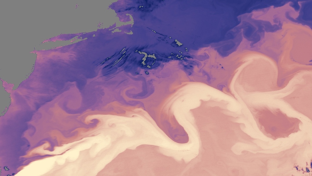
Wind, heat and the shape of the Atlantic basin squeeze seawater into a swift ribbon called the Gulf Stream. For the everyday question of which ocean current has the greatest measured flow speed, that ribbon is the usual answer. Its fastest water runs near the surface and can reach about 9 kilometers per hour, or 5.6 miles per hour. Four knots is quick for a broad river of seawater moving across an ocean.
The figure needs a little context. Current speeds change with depth, season, weather and location. NOAA Ocean Service reports that the Gulf Stream averages about four miles per hour, while its maximum surface speed is typically 5.6 miles per hour. The current spreads and slows farther north. NOAA’s speed summary makes the useful distinction between its peak and average motion.
Oceanographers also use “strongest” to describe the amount of water a current carries. The transport measure points south, toward the current that circles Antarctica. Both records matter, yet they answer separate questions about a moving ocean.
Speed depends on the question
Velocity measures how fast a parcel of water travels past a fixed point. A surface drifter, a current meter, or an acoustic instrument can estimate its speed. The result may be reported in miles per hour, kilometers per hour, or meters per second. Peak velocity is what most people picture when they ask about the fastest current. It captures the speed of the liveliest part of the flow.
Transport measures something larger: the volume of water crossing a line in a given time. Width and depth count as much as local speed. A wide, deep current can carry a staggering amount of water even when a small surface jet elsewhere is racing faster. Scientists often express this flow in Sverdrups, where one Sverdrup equals one million cubic meters per second.
Speed and transport explain why a single superlative can cause confusion. A fast jet can win on peak velocity. A deep belt that spans a huge part of the ocean can win on transport. Tide-driven passages and brief storm flows add another layer, since their speed may rise and fall over hours. The Gulf Stream comparison usually concerns persistent, large-scale surface currents.
Depth matters particularly strongly. Sun-warmed surface water responds directly to wind and can form a narrow, energetic band. Beneath it, friction and density differences may change the direction and speed of the flow. A single measurement taken from a ship therefore describes one layer and one moment. Oceanographers combine many observations to map a current through time and from the surface toward the seafloor. Oceanographic reports therefore identify whether a number is a maximum, an average, a surface value, or a transport estimate. Instruments also have different strengths. A drifting buoy follows water near its depth. An acoustic Doppler profiler estimates speed across several layers. Satellite maps reveal surface patterns over wide areas. Each description answers a useful question about the same circulation.
The Gulf Stream reaches the highest surface speeds
In the western North Atlantic, the Gulf Stream flows north along the coast of Florida, turns east off North Carolina and then heads northeast across the Atlantic. It gathers warm tropical water into a narrow, powerful corridor. The basin’s geography helps build a western boundary current, the fast side of a wind-driven ocean gyre.
Earth’s rotation steers moving water, while trade winds and westerly winds help pile water toward the western side of the North Atlantic. Differences in sea level and pressure then support a strong northward flow along the coast. The result is a current that is much faster than the broad, slow water found across much of the open ocean.
Its heat transport has consequences well beyond the current itself. The Gulf Stream carries warm water northward and influences the air above the Atlantic. It also forms a sharp boundary between water masses. The current boundary can shape weather, fog, marine habitat and the route of floating material. At the same time, its speed has no single value for every mile of its course. The maximum quoted by NOAA describes its fastest near-surface water.
The Florida Current feeds the Gulf Stream
The name Florida Current is often used for the flow through the Florida Straits, between Florida and the Bahamas. Water arriving from the Caribbean and the Gulf of Mexico passes through this narrow gateway before joining the broader Gulf Stream system. The link between speed and transport makes casual labels easy to mix up.
NOAA describes the Loop Current as warm water that travels from the Caribbean through the Gulf of Mexico and into the Florida Straits. Its path shifts over time. After the flow exits the straits, it continues northward in the Atlantic circulation that develops into the Gulf Stream. The names identify linked stretches of water in different places.
Measurements near the Florida Straits can reveal very rapid water because the passage concentrates the flow. Still, a sound answer should state the location and measurement. Calling every fast reading “the Gulf Stream” can blur a regional current with the full Atlantic feature. The broader Gulf Stream remains the conventional answer when the question is framed around the world’s fastest major ocean current.
Antarctica has the largest current system
Far to the south, the Antarctic Circumpolar Current flows eastward around Antarctica without a continent blocking its path. It joins the Atlantic, Pacific and Indian oceans. Strong westerly winds drive the system and its reach extends from the surface toward the deep sea. Woods Hole Oceanographic Institution calls it the largest wind-driven current on Earth.
Its scale is the key. The current is wide, deep and long enough to encircle the continent. Its width and depth give it immense volume transport. A scientific review describes a transport of roughly 130 Sverdrups along a 24,000-kilometer path, although estimates vary with the section and method used. Such numbers describe the full moving belt rather than a small patch of its fastest surface water.
Antarctic circumpolar circulation helps exchange heat, carbon, nutrients and water between ocean basins. Jamie Allan of the U.S. National Science Foundation said, “A better understanding of sea-air exchange in the Antarctic Circumpolar Current will enable more accurate forecasting of the rate and magnitude of future climate change related to increasing atmospheric carbon dioxide levels.” The NSF account describes why scientists study its past behavior.
Velocity and transport tell different stories
For a short answer, the Gulf Stream has the fastest commonly cited surface speed among the major persistent ocean currents, with peaks near 5.6 miles per hour. For the largest flow of water, the Antarctic Circumpolar Current takes the spotlight. Keeping those labels separate preserves the physical meaning of both measurements.
Researchers watch more than a single number. Satellites track sea-surface height and temperature patterns. Shipboard instruments measure the water column. Drifting buoys show pathways, while moorings collect records over months or years. Woods Hole explains that western boundary currents can exceed five miles per hour, a group that includes the Gulf Stream, Kuroshio and Agulhas currents.
The careful wording also leaves room for a changing ocean. A current can shift, widen, split into eddies, or change speed at a particular place. Peak current speed remains a local measurement. Total transport is a system-wide calculation. Instruments also sample different depths and time intervals, so researchers compare overlapping records before treating a brief peak as representative of an entire current. Together, these measurements turn a simple ocean trivia question into a clearer view of how Earth moves heat and water around the planet.
Speed is one reason opposite sides of a subtropical gyre look so different. Western boundary currents are narrow and fast, while eastern boundary currents are broader and slower.





