
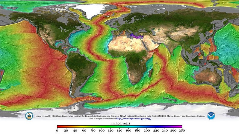
Nearly 65,000 kilometers of underwater mountains trace the places where Earth’s plates pull apart. Along this global ridge system, seafloor spreading steadily adds fresh oceanic crust. The process is slow on a human clock, yet it has helped reshape ocean basins for millions of years.
At a mid-ocean ridge, two tectonic plates move away from one another. Hot rock rises from below, melts as pressure drops and supplies magma to the gap. That material cools into volcanic rock called basalt. Each new addition pushes older seafloor outward on both sides of the ridge.
The ridge network circles the planet through the Atlantic, Pacific, Indian and Southern oceans. Most of it lies far below the waves. Its activity links volcanism, earthquakes, deep-sea landscapes and the ongoing movement of continents.
Where new ocean crust begins
Divergent plate boundaries provide the setting for seafloor spreading. Earth’s outer rocky shell is divided into moving plates. At a spreading center, neighboring plates separate gradually. The stretched crust develops fractures that allow molten material to rise toward the seafloor.
The resulting ridge is a long volcanic mountain chain rather than a single peak. The Mid-Atlantic Ridge runs between the Americas and Europe and Africa. It is a slower-spreading system. NOAA Ocean Exploration reports rates of about 2 to 5 centimeters per year there, while the East Pacific Rise spreads much faster, about 6 to 16 centimeters per year.
Those different rates help create different landscapes. Slow ridges often have a deep central rift valley and rugged slopes. Faster ridges tend to have broader, smoother crests. The NOAA Pacific Marine Environmental Laboratory describes the global ridge system as Earth’s largest single volcanic feature.
Ridge segments are also offset by transform faults, where plates slide past one another. These breaks divide a long ridge into shorter sections. Earthquakes can occur along the faults and during magma movement beneath the ridge. Together, spreading and faulting give the seafloor its patterned ridges, valleys and fracture zones.
Although it is hidden by the ocean, the ridge system rises from deep seafloor into a long chain of submarine mountains. NOAA says the average water depth to a ridge top is about 2,500 meters. Individual ridge segments can erupt at different times, adding new volcanic rock in pulses rather than as one continuous surface flow.
How magma becomes seafloor
Below a ridge, mantle rock rises as the plates separate. The falling pressure lets part of that hot rock melt. This process supplies basaltic magma, the dark molten rock associated with most oceanic crust.
Some magma erupts onto the seafloor and cools quickly in seawater. Much of it freezes below the surface in the growing crust. The result is a layered package of volcanic and deeper rock. The new crust is warm and relatively light when it forms, then cools and grows denser as it travels away from the ridge.
That outward motion happens on both flanks of a spreading center. A band of crust near the ridge is young because it formed recently. Farther away, the rocks have spent more time moving with their plate. USGS explains that the age of the seafloor increases away from ridge crests, a pattern that became central evidence for plate tectonics.
New oceanic crust is more than a thin skin of erupted lava. Melt can cool within the crust before reaching the seafloor, adding rock from below. At a typical ridge, the full crust is roughly 10 kilometers thick. Eruptions form only part of that thickness, while other magma solidifies deeper underground.
Magnetic stripes made the case
The story of seafloor spreading gained force from ocean-floor maps and magnetic measurements. During the 1950s and 1960s, scientists found long bands of stronger and weaker magnetic signals in basalt on either side of ridges. The bands formed matching patterns across a ridge.
When basalt cools, magnetic minerals within it align with Earth’s magnetic field. Earth’s field has reversed many times during geologic history. Successive lava flows therefore preserved alternating bands of normal and reversed magnetic orientation. These magnetic stripes recorded both the timing of reversals and the creation of new crust.
The symmetry mattered. If crust formed at a ridge and moved outward in two directions, corresponding magnetic bands should appear on both sides. That was the observed result. The NOAA National Centers for Environmental Information notes that alternating ocean magnetization reflects seafloor spreading and changes in geomagnetic polarity.
Harry H. Hess advanced an early seafloor-spreading hypothesis in his 1962 paper, “History of Ocean Basins.” Later magnetic evidence and ocean exploration supplied the support the idea needed. The USGS history of Hess traces how these observations helped establish the modern framework of plate tectonics.
Drilling added another test. Cores collected from the seafloor showed that rocks close to ridge crests are younger than rocks farther away. Their ages and magnetic histories fit the same outward-moving pattern. Several independent lines of evidence thus connected volcanic ridges with the growth of the ocean floor.
Old crust returns to the mantle
Oceanic crust is continually renewed at ridges. As a plate moves away from a ridge, it cools, thickens and becomes denser. At many convergent boundaries, old oceanic lithosphere bends downward beneath another plate. This descent is called subduction.
Deep ocean trenches mark many of these recycling zones. Material carried downward is heated and altered deep within Earth. Over geologic time, the pairing of crust creation at ridges and crust consumption at subduction zones helps keep the planet’s surface area broadly balanced.
This recycling also explains why present ocean basins lack extremely ancient seafloor. Continental rocks can preserve a much longer record. Oceanic crust is continually created, carried across a basin and eventually drawn back into the mantle. The USGS ocean glossary identifies spreading centers and subduction zones as linked features of the moving plate system.
Subduction can also fuel volcanism and earthquakes around ocean margins. As a descending slab carries water and minerals downward, conditions above it can help generate melt. The resulting volcanic chains and active faults show that the plate cycle connects processes deep below the seafloor with hazards on land and beneath the ocean.
Why spreading still matters
Seafloor spreading provides a clear mechanism for continental drift. As oceanic plates form and move, they carry continents that sit on connected plates. The Atlantic Ocean has widened as new crust formed along the Mid-Atlantic Ridge. The plates on either side carry the Americas, Europe and Africa.
The process also shapes the deep ocean in ways that affect life and research. Ridge volcanism and fractures can support hydrothermal systems, where heated fluids circulate through rock and emerge at the seafloor. These areas host unusual ecosystems and offer clues about how water, heat and chemicals move through Earth’s crust.
Scientists continue to map ridges, sample rocks and measure magnetic patterns because the system holds a long record of plate motion. Seafloor spreading turns that record into a moving archive. It reveals how ocean basins open, how crust ages and how Earth renews its ocean floor.
Modern surveys use sonar, rock samples, seismic measurements and magnetic data to refine that archive. Large parts of the ridge system remain difficult to observe because their depth and remoteness complicate work by research vessels and instruments. Each expedition can improve maps of the seafloor and help researchers track the changing boundary between Earth’s plates.
Sonar measurements reveal the broad shape of an underwater ridge. Seismic signals help scientists examine rocks below it. Samples and magnetic readings add a timeline to the map. Used together, these tools show where crust formed, how it moved and how activity at ridges differs from one ocean basin to another.





