A 2026 study in Nature Communications finds signs that the Arctic’s freshwater routes are changing. The observed signal is a rise in dynamic sea level north of Greenland, in the eastern Last Ice Area. The authors say that change has helped steer a larger share of recent liquid freshwater export toward Fram Strait. Their climate simulations project a much larger route shift later this century under a high-emissions scenario. Those results describe a possible future pathway, while the recent satellite and transport records point to an early transition that still needs sustained monitoring.
Freshwater leaving the Arctic can influence the salinity, layering and chemistry of the subpolar North Atlantic. It travels south through a small number of gateways, carrying dissolved material and water from the Arctic’s upper ocean. Qiang Wang and colleagues identify the waters north of Greenland as a key junction. Their work joins present-day observations with a high-resolution ocean and sea-ice model, offering a closer look at how a regional change in sea level can alter a much larger current system.
A sea-level signal north of Greenland
The sea-level change in this study is dynamic. It describes an ocean-surface difference caused by changing density and circulation after the global average rise has been removed. Freshwater, winds and salinity all contribute. Fresh water is less dense than salty water, so its movement can lift the local ocean surface. Near Greenland’s northern coast, even a subtle slope in that surface can help guide currents toward one exit or another.
Observations show that the Beaufort Gyre, a large clockwise circulation in the Canada Basin, built up freshwater from the mid-2000s and reached a record level by the late 2010s. The paper says part of that excess water has since been released during a cyclonic wind pattern over the Canada Basin. Freshwater content then increased in the eastern Last Ice Area. Satellite measurements and the researchers’ hindcast simulation both show the associated rise in dynamic sea level there.
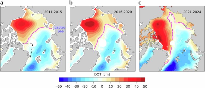
That observed rise matters because the shape of the sea surface influences the direction of surface currents. The authors report that contour lines of dynamic sea level became more aligned toward Fram Strait after the mid-2010s. Their transport reconstruction also shows a rebound in the Fram Strait share even while sea level in the subpolar North Atlantic remained relatively low. The team interprets this pattern as evidence that conditions north of Greenland are beginning to redirect upper-ocean flow.
Two exits for Arctic freshwater
The Arctic has two main ocean routes for sending freshwater toward the North Atlantic. Fram Strait lies between Greenland and Svalbard. The other route runs through the narrow channels of the Canadian Arctic Archipelago and reaches the Labrador Sea through Davis Strait. The National Snow and Ice Data Center describes Fram Strait as the passage where most drifting Arctic sea ice leaves the basin.
Those routes carry more than water. Arctic outflow can move nutrients, carbon-rich material and other chemical tracers into the subpolar North Atlantic. Where fresh water enters also affects how readily surface waters become dense enough to mix downward. That is why the paper focuses on the partitioning, or division, of export between Fram Strait and the Canadian Archipelago rather than on a single total-flow number.
Sea ice once carried a substantial share of Arctic freshwater south through Fram Strait. The new paper says shrinking sea ice has reduced that solid freshwater export, making liquid freshwater increasingly important. NSIDC’s overview of the science of sea ice explains how ice forms from seawater and moves with winds and currents. As that ice cover changes, the liquid pathways become an especially important part of the Arctic-to-Atlantic connection.
What the models project
For the future analysis, the researchers ran a high-resolution FESOM2 simulation from 1900 through 2100. It used atmospheric conditions from the CMIP6 SSP585 scenario, a high-emissions pathway and represented the Arctic Ocean at finer detail than many global climate models. Its Arctic grid spacing was about 4.5 kilometers. That detail helps resolve coastlines and freshwater patterns that coarse global models can blur. They also compared its broad result with projections from 24 CMIP6 models. The model was checked against observed Arctic freshwater distribution, salinity structure and gateway transports before the team examined future changes.
Under that scenario, the model projects more freshwater in the Canada Basin and an eastward spread of that fresh water into the Last Ice Area by mid-century. Dynamic sea level north of Greenland rises along with it. The projected share of total Arctic volume export passing through Fram Strait increases from roughly 55 percent in the late twentieth century to nearly 80 percent in the 2050s. That is an increase of more than 40 percent in the modeled share, rather than a measurement of today’s flow.
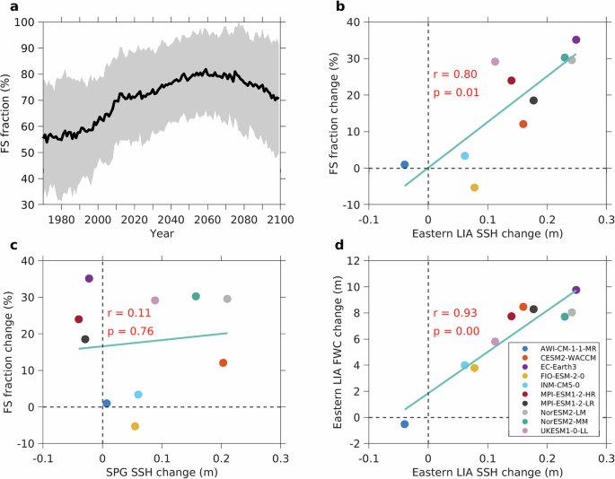
The projection then changes direction. After mid-century, saltier Eurasian water intrudes and the modeled dynamic sea level in the eastern Last Ice Area falls. The Fram Strait export share declines while the Davis Strait share moves the other way. This non-linear sequence is a central result of the study. It is conditional on the model setup and emissions scenario, so it does not establish that the full rise-and-fall pattern has already occurred in the real ocean.
One extra model experiment helps separate the possible drivers. The researchers reran 2015 through 2100 with future Arctic winds replaced by winds from a century earlier. Through the middle of the century, that change had limited effect on the modeled sea level north of Greenland or on the division of export between the two gateways. The authors therefore link the projected mid-century reorganization chiefly to freshwater accumulation and circulation changes. They also note an important limit: their high-resolution simulation did not include additional freshwater from future Greenland Ice Sheet melt. That missing input could alter the size of the response, which is another reason to treat the numbers as projections rather than a precise forecast.
Why the route shift reaches beyond the Arctic
To see where the water could go, the team released virtual dyes at the export gateways in the model. Within five years, material from both routes reached the southern edge of the subpolar gyre. The Fram Strait tracer traveled farther into the Labrador Sea and the gyre’s interior. A future rise in its export therefore could redistribute Arctic-sourced fresh water and dissolved materials around Greenland and across the subpolar North Atlantic.
Such a shift could matter for salinity and biogeochemistry, the study says. It can also matter for research on the Atlantic overturning circulation, which depends in part on the creation of dense water in northern seas. The paper does not calculate a future slowdown of that circulation from this route change. Its result identifies a freshwater pathway that climate scientists will need to track when evaluating broader North Atlantic changes.
Recent Arctic change already provides a setting for that work. NOAA’s 2025 assessment of Arctic atlantification describes warmer and saltier Atlantic-origin water moving northward. It also describes effects on sea ice, currents, mixing and ecosystems. That process differs from the freshwater export studied here, yet both involve changing pathways across the Arctic Ocean. Together they show why one region’s circulation can reshape conditions far from the original source water.
The next test is continued observation. The study’s recent evidence combines satellite sea-surface height with records of freshwater transport and it finds an emerging Fram Strait signal. The NOAA Arctic Report Card emphasizes the value of repeated observations across the Arctic system. Satellites, moorings, floats and ships can show whether the north-of-Greenland pattern persists. They can measure freshwater reaching each gateway. They can also show whether the observed transition follows the projected route or develops in a different way.