
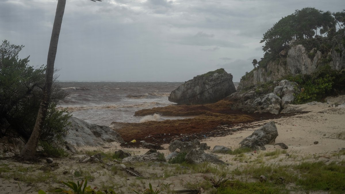
Researchers at the University of South Florida had already warned in their June 30 Sargassum Watch bulletin that 2026 was on track to become at least the second-largest sargassum year on record. By Friday, AP reported that the lab’s July estimate for the Atlantic region stood at about 27 million metric tons. The reported tally still described an extraordinary bloom even after June’s higher total.
The July and June totals help explain why beaches from Mexico to Puerto Rico have remained clogged with brown mats even when offshore totals shift from one month to the next. A bloom of that size can keep feeding new coastal landings for weeks. Some of the floating algae is still arriving from the broader Atlantic belt and scientists now say some of it also appears to be growing within the Caribbean and Gulf.
How July fits into a historic 2026 bloom
The most concrete public benchmark still visible from USF on July 31 is the June 30 outlook bulletin. It put June 2026 at 33.6 million metric tons across the Atlantic region and said the total in the Gulf of Mexico reached 5.0 million metric tons. The bulletin also said 2026 was running only 10% below the 2025 record, which is why the lab described this year as likely the second largest yet.
July’s reported 27 million metric tons does not mean the problem suddenly became small. It means the bloom stayed enormous after the usual early-summer peak. Sargassum in the tropical Atlantic often rises into June or July, then shifts in location and density as winds and currents move biomass toward shore. Beaching events remove part of that biomass from open water and stack it along the coast.
Monthly totals also describe a huge region rather than the view from one beach. A basin-scale estimate can fall while local shorelines get worse because floating mats have started piling into narrow coastal zones. Shoreline landings and pileups say more about local damage than the basin number alone. Hotel districts and fishing harbors can take direct hits. Turtle nesting beaches can too.
Why beaches can stay buried after the offshore peak
NOAA and USF track that coastal hazard with the daily Sargassum Inundation Risk report. The system uses USF satellite detections and NOAA analysis to flag beaches where currents and nearby algae make landings more likely. That product exists because offshore abundance and shoreline impact are related, but they are not identical.
Wind can push surface mats toward the coast for days at a time. Nearshore currents can then trap the algae in embayments and behind reefs. Gently sloped beaches can become difficult cleanup zones once the piles start building. A region may therefore see repeated beaching events from the same broad bloom, especially when fresh mats keep arriving before older piles are cleared.
Brian Barnes of USF told AP that the 2025 bloom was so large that it helped seed a new local bloom in 2026. That explanation fits the wider pattern in USF’s public materials. The Great Atlantic Sargassum Belt still supplies much of the floating biomass, yet the Caribbean and Gulf are no longer acting only as downstream collection zones during this heavy year.
The monitoring challenge is one reason coastal managers rely on the Sargassum Watch System. Satellite maps can show where large mats remain offshore before they appear on an individual beach. Daily risk products help local officials decide when to deploy crews and when to warn residents. The same products also show which stretches of coast may need the fastest response.
What the algae does to coastal ecosystems
Floating sargassum in the open ocean is not automatically bad. NOAA notes that pelagic sargassum can provide habitat for wildlife, especially fish and turtles. Trouble starts when too much of it moves into shallow water or settles on the shore, where the same biomass begins to block light and alter water chemistry.
The EPA’s page on aquatic and ecosystem impacts explains why coastal accumulations are so damaging. Decay can drive down nearshore oxygen. It also lowers pH and can raise hydrogen sulfide or ammonia. Those changes can kill fish and benthic animals. They also stress corals and damage seagrass beds or mangrove areas that many young marine species depend on.
Heavy mats also create a physical barrier. Sunlight has a harder time reaching seagrasses and reef organisms under dense rafts. Newly hatched sea turtles can struggle to cross piled seaweed on the beach and mechanical removal can disturb nests if crews have to work quickly during the tourism season.
Why rotting mats become a health problem on land
Once sargassum sits onshore for long enough to rot, coastal residents face more than an ugly beach. The EPA’s page on human health impacts says decomposing mats can release hydrogen sulfide and ammonia. The same piles can produce odors strong enough to keep people away from nearby buildings and public shoreline areas.
Hydrogen sulfide is the gas that creates the familiar rotten-egg smell. EPA says exposure can irritate airways and eyes. It can also trigger nausea and headaches, along with other symptoms, especially for people with asthma or other respiratory problems. Ammonia adds another irritating gas burden in places where large piles are left to decay in heat.
The odor and gas exposure help explain why the bloom has become an economic story as well as an ecological one. A beach that looks swimmable in a postcard can become unusable once visitors have to climb over algae. Many people also turn away when they smell gas from decomposing mats or see dark water at the shoreline. Cleanup crews can remove part of the problem, but the work becomes expensive when new landings keep arriving every few days.
EPA also notes that workers who handle stranded sargassum may need protective gear because exposure rises when people spend hours close to decaying piles. The warning is especially relevant in places where heavy equipment and hand crews are clearing beaches day after day. A bloom that lasts for much of the summer turns cleanup into an occupational-health issue, not just a tourism nuisance.
Why scientists think the pattern is changing
USF and NOAA researchers have been careful not to pin the bloom on one simple cause. Their long-running descriptions of the Great Atlantic Sargassum Belt point to a mix of conditions that favor growth. Warm water and abundant sunlight help. Changing currents also influence growth. Added nutrients from coastal runoff and open-ocean sources such as upwelling or dust can feed the bloom as well.
USF highlighted that broader trend again in a 2026 report on AI-detected macroalgae expansion. The research team found that floating macroalgae blooms in the tropical Atlantic and western Pacific increased by 13.4% per year from 2003 to 2022. That result does not prove that every future summer will beat the last one, but it does show that the background conditions have shifted over the past two decades.
The 2026 season now looks like another sign that the Atlantic system has entered a higher-biomass era. July’s 27 million metric tons came in below June’s public USF estimate, yet it still left an immense amount of seaweed in the water. For coastal communities, the central question is no longer whether the bloom is real. The question is how long shorelines can keep absorbing repeated landings from a belt that has grown too large to dismiss as a short-lived anomaly.
Public tracking tools also reveal how uneven the burden can be. One island may face persistent landings while another nearby coast gets a temporary break because winds shift or currents bend the mats away. That patchiness makes local forecasting essential. It also explains why residents can feel that conditions are getting worse even when the regional total has edged down from one month to the next.





