
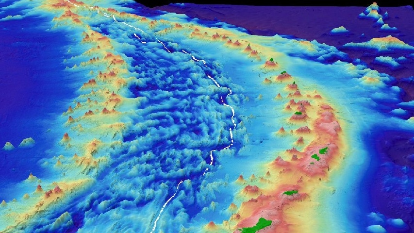
NOAA’s NCEI describes the Mariana Trench as the product of a slow collision between ocean plates. One plate bends, then descends into Earth’s mantle, drawing the edge of the plate above it downward and leaving a long trough in the seafloor. That motion has built the deepest valleys on the planet. It also links the quietest reaches of the ocean to earthquakes, volcanoes and islands far overhead.
Where the seafloor folds downward
Ocean trenches are narrow, deep depressions on the seafloor. Their sides form a broad V or U shape that can extend for hundreds or thousands of miles. Most lie around the Pacific Ocean’s active rim, where pieces of Earth’s outer shell meet. The famous Mariana Trench curves through the western Pacific east of the Mariana Islands. Its deepest known area, Challenger Deep, sits close to 11 kilometers below sea level.
Depth makes a trench striking, but location explains it. A trench marks a boundary between tectonic plates, the huge slabs of rock that carry oceans and continents. These boundaries shift by centimeters each year. Over millions of years, that steady motion reshapes whole ocean basins. NOAA’s ocean-depth overview places Challenger Deep in the southern Mariana Trench and gives its depth as roughly 10,935 meters.
Maps make these landforms visible through water that is far too deep for divers. Survey ships send sound pulses toward the bottom and measure their return. Repeated passes create a detailed picture called bathymetry. On those maps, a trench appears as a dark, elongated cut beside an island chain or a continental margin. Its outline records the place where tectonic plates have met for ages.
The plate motion that starts a trench
The process is called subduction. It begins where two plates move toward each other. Oceanic crust cools and grows denser as it ages. At many converging boundaries, the colder and denser oceanic plate bends down beneath the neighboring plate. The bending point becomes the trench. Far below, the sinking slab continues into the mantle, where hotter rock gradually changes its structure.
Picture a stiff sheet being pushed over the edge of a table. The sheet curves first, then drops. The seafloor behaves in a similar way, although the forces act across vast distances and over geologic time. The upper plate is pulled down near the contact, while the incoming plate flexes and cracks. NOAA Ocean Exploration’s Aleutian geology primer notes that these subduction zones can create trenches more than 11,000 meters deep.
Before the plate disappears from view, it often rises slightly into an outer swell. Cracks can open where the plate bends. Sediments carried on the incoming plate may be scraped and squeezed near the boundary. In some regions, that material builds a low ridge beside the trench. This shifting zone shows that the seafloor is moving and deforming long before the slab reaches deeper mantle.
Why some trenches become so deep
Age matters because older oceanic crust has spent longer cooling. It becomes heavier than younger crust and can sink more readily. The angle of the descending slab matters too. A steep slab can help create a particularly deep trough. Sediment adds another variable. Rivers, underwater landslides and currents deliver sand and mud to the sea and some of that material can partly fill a trench over time.
The Mariana system combines several features that favor exceptional depth. The Pacific Plate is old and dense where it meets the Philippine Sea Plate. The boundary also has a complex history of plate movement. NOAA Fisheries describes the Mariana Trench Marine National Monument as a geologically complex region with a subduction zone, back-arc basins, submarine volcanoes and Challenger Deep at about 36,000 feet.
Trench floors therefore vary from one boundary to another. Some receive thick blankets of sediment, which soften their shape and reduce their apparent depth. Others remain sharply defined because less material reaches them. The age, density and path of the sinking oceanic crust work together with this sediment supply. Geologists read those differences as clues to the long history of a plate boundary.
Earthquakes, volcanoes and island arcs
Friction and stress build as the plates press together. When a locked section suddenly slips, the stored energy travels as an earthquake. Subduction zones host many of the world’s largest earthquakes and undersea quakes can move enough water to generate tsunamis. The depth and shape of the descending slab also influence where earthquakes occur beneath a trench and the land or islands beside it.
Water carried downward with the plate changes rocks in the mantle above it. That helps some mantle rock melt. Melted rock rises and can feed volcanoes on the upper plate. Where the upper plate is oceanic, repeated eruptions may build a curved chain of volcanic islands called an island arc. Where a continent lies above the boundary, the same broad system can help build volcanic mountain belts. The trench, the quake zone and the volcanoes are parts of one moving plate system.
The distance between a trench and its volcanoes can be large. The descending plate must reach conditions that release water into the mantle above it. That is why a map of a subduction zone often shows a trench offshore and volcanoes farther inland or on the opposite side of an island chain. This geometry helps researchers connect events on the seafloor with activity that people may see on land.
Life and exploration at full ocean depth
Below about 6,000 meters lies the hadal zone, named for Hades, the ancient Greek underworld. Sunlight does not reach it, temperatures are low and the water pressure is immense. Even so, the deep seafloor supports microbes and animals adapted to these conditions. Food often arrives as sinking organic material from waters above. In some places, chemical energy from the seafloor can also support communities.
Scientists still have a partial view of these remote places. Sonar maps reveal the contours of the seafloor, while landers, submersibles and remotely operated vehicles collect images and samples. NOAA Ocean Exploration explains that multibeam mapping helped refine the measured depth of Challenger Deep. Each expedition adds detail to a map that connects Earth’s deepest waters to the restless crust beneath them.
Pressure is one reason exploration takes special equipment. Water presses from every direction and the force rises with depth. Instruments need strong housings, reliable power and careful communication systems. Yet the effort pays off. Samples, images and measurements show how deep communities live, while repeated surveys reveal changes along active plate boundaries. In the trenches, geology and ocean science meet at full ocean depth.





