
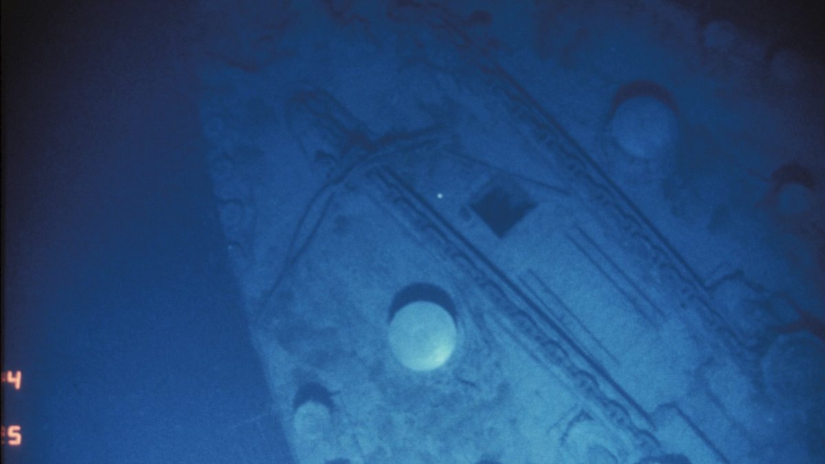
For 73 years, RMS Titanic lay beyond the reach of searchers in a cold, lightless part of the North Atlantic. Its final position was uncertain across a broad area of seafloor almost 12,500 feet below the surface. Before dawn on September 1, 1985, a tired crew aboard the research vessel Knorr saw the telltale form of a boiler on a video screen. The sight marked the first physical confirmation that the wreck had been found.
The discovery grew from an international effort led by Woods Hole Oceanographic Institution, or WHOI, with France’s IFREMER and led at sea by Robert Ballard. WHOI’s 2025 account describes a search that joined a French survey, a new American imaging system and a last-minute change in strategy. The prize was famous, yet the working methods were built for a wider future in deep-ocean exploration.
Argo gave the team a way to spot a scattered path of objects on the seabed, then trace that evidence toward the wreck. Its cameras could reveal clues before the complete ship came into view. That approach drew on lessons from submarine surveys and on the way a sinking ship can break apart before its remains reach the bottom.
A French survey narrowed the field
The first phase of the 1985 expedition used IFREMER’s new SAR side-scan sonar from the French research vessel Le Suroit. Side-scan sonar sends sound across the seafloor and records returning echoes. A ship can leave a strong shape in those data, although underwater valleys and uneven terrain can complicate the picture. The search lines overlapped in a careful pattern often called mowing the lawn.
Le Suroit spent 31 days in rough North Atlantic conditions and used up its allotted ship time without locating Titanic. The French work still removed a large share of the possible search ground. In WHOI’s history of the discovery, three IFREMER scientists then joined Knorr at Ponta Delgada in the Azores. The American phase began from the edge of the survey already completed.
WHOI’s account places the search area around Titanic Canyon, a submarine valley with branching tributaries. Such terrain could create confusing sonar echoes and conceal a ship-shaped target among natural features. The French plan used overlapping tracks about 800 meters apart. It aimed for orderly coverage of the chosen area and gave the next team a known starting point within the remaining survey field.
Navy work shaped the American phase
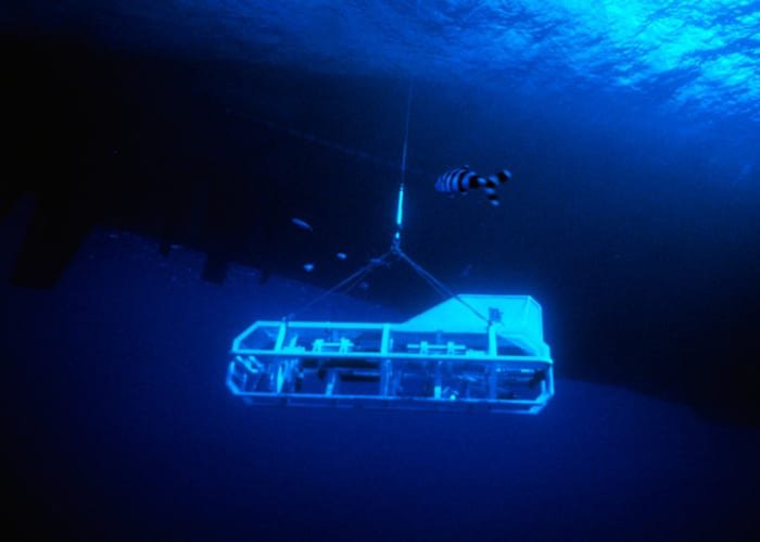
Knorr carried Argo as part of a deep-water technology program. The system was a large towed sled with low-light television cameras and sonar, linked to the ship so that scientists could watch the ocean floor in real time. That live view mattered because it let the crew assess unusual features while the vehicle was still moving across the bottom.
A classified U.S. Navy assignment formed an important part of Ballard’s 1985 schedule. A later Navy account says he was tasked to study the wreck sites of the USS Thresher and USS Scorpion, nuclear submarines lost in the 1960s. WHOI’s 2025 release specifically describes Knorr setting out to survey Scorpion. The Navy account says Ballard received time for Titanic after that classified work, which placed a firm limit on the public search.
The vehicle itself had grown from an Argo/Jason development effort supported by the Navy’s Office of Naval Research. WHOI says the first Argo phase paired low-light television cameras with a vehicle designed to work as deep as 20,000 feet. That engineering goal fit the physical challenge at Titanic’s depth. The system’s wide-area imaging capability suited a search across a large and poorly defined section of seafloor.
A debris trail offered a workable target
The team’s key insight concerned the violence of a deep sinking. Titanic had broken apart before it reached the seafloor, spreading smaller pieces outward as they settled. A wreck field could cover a much larger space than the ship itself. It also offered many more possible visual clues, from machinery to coal and parts of the liner’s structure.
Ballard’s team used debris-field analysis to turn that pattern into a search plan. Experience from the Scorpion survey showed that wreckage could form a trail more than a mile long. Argo could run wider-spaced tracks across the remaining area while looking for that trail. The plan suited the short window available to Knorr and the broad field left after the French sonar survey.
The search therefore focused on a pattern of evidence. A loose trail gave the team a feature they could cross even when the ship itself was still outside the camera’s view. Once they found one recognizable object, the direction and spacing of nearby material could guide the next pass. This made a demanding navigation problem more manageable while evidence accumulated across the seafloor.
One boiler changed the night
Just after 1:00 a.m. on September 1, the monitors showed a boiler with a distinctive rivet pattern. It was a familiar object from Titanic, yet its appearance on a nearly featureless deep-sea plain carried extraordinary weight. The crew had spent less than a week scanning for the debris trail when that first unmistakable clue arrived.
From the boiler, the team followed the debris north until the wreck came into view. Argo supplied video and the companion camera system ANGUS recorded 35-millimeter film during the remaining days of the cruise. The sighting confirmed the ship’s location after decades of failed attempts and made it possible to document the site without sending people down on the 1985 voyage.
The boiler mattered because its construction details connected the image to the missing liner. WHOI identifies the rivet pattern as the first evidence that the Knorr researchers had found RMS Titanic. The discovery came at almost the same hour that the ship had sunk in 1912, according to the institution’s historical account. Some crew members later held a brief memorial service on Knorr for the people lost in the disaster.
Argo became a model for deep-sea imaging
The successful search tested more than a single vehicle. WHOI describes both Argo and the French SAR system as technologies still undergoing sea trials in 1985. Their performance showed how large-area sonar, video, navigation and patient ship operations could work together. Dana Yoerger was a WHOI scientist on the discovery team. He recalled: “Ballard taught us all that searching in the ocean requires planning, the right mix of technologies, patience and discipline.”
Argo soon moved from a celebrated wreck search to a scientific survey. In December 1985, Ballard and colleagues used it on a 120-mile section of the East Pacific Rise, an undersea mountain range between San Diego and Manzanillo. WHOI says the cruise gathered about 170 hours of videotape. It showed why a high-altitude imaging sled could quickly extend scientists’ view of a seafloor landscape that had previously been examined only in small pieces.
Nine months later, WHOI returned with the human-occupied submersible Alvin and the small remotely operated vehicle Jason Jr. for a closer examination. The 1986 return tested Jason Jr. while Alvin served as a stable platform on the seafloor. Those dives produced close images of the wreck and helped advance the Argo/Jason system that later supported ocean science.
The 1985 discovery therefore left two connected legacies. It identified the resting place of a ship whose loss killed more than 1,500 people and it demonstrated a practical way to search the deep ocean at scale. Cameras and sonar have changed greatly since then, with autonomous and remotely operated vehicles expanding the range of deep-water work. The underlying lesson remains durable: broad surveys, clear navigation and physical clues on the seafloor can reveal places that once seemed unreachable.





