
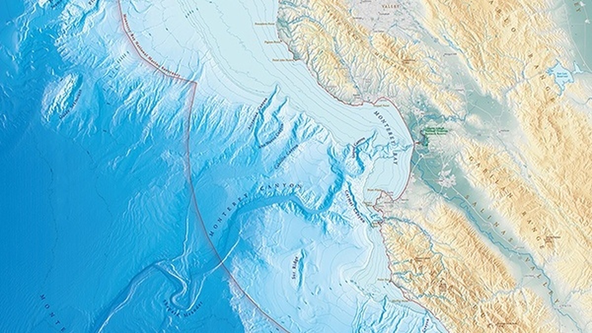
In 1857, a set of depth measurements in Monterey Bay produced a surprise that no sailor could see from the deck. James Alden, commanding the Coast Survey Steamer Active, traced a deep valley running through the bay. The feature would become known as Monterey Canyon and NOAA records describe it as the first known seafloor canyon.
The discovery arrived in an era when the sea bottom was largely a blank space on maps. Alden and his crew were working for the U.S. Coast Survey, whose charts helped vessels approach a fast-changing western coast. NOAA’s account of the discovery preserves a rare view of how an unfamiliar shape beneath the water first entered the scientific record.
A valley appears beneath Monterey Bay
Alden’s party had completed soundings north of Point Pinos, across the bay and west toward Santa Cruz Harbor when the pattern emerged. A sounding is a measured water depth. Repeated measurements can turn scattered numbers into a picture of the bottom, especially when a survey crew follows planned lines across an area.
In the Coast Survey report, Alden called the feature a “deep sub-marine valley, or ‘gulch,’ directly in the middle” of the bay. That short description carried a great deal of information. The valley was wide at its mouth, narrowed as it came toward shore and brought unusually deep water close to the beach.
The report also referred to the 50-fathom curve. A fathom is six feet, or about 1.8 meters. Surveyors used such depth lines to show where water reached the same depth. The curve gave them a way to describe the valley’s broad opening without seeing the seafloor itself.
A chart built from these readings did more than mark deep and shallow spots. It let a navigator compare one sounding with the next and recognize a continuous landform. On land, a valley can be followed with the eye. Underwater, its presence had to be inferred from a changing pattern of depth, then set down in a form others could inspect and use.
How a nineteenth-century survey found it
Before electronic instruments, crews practiced lead-line soundings. A weighted line was lowered until it touched bottom, then the crew read the depth from marks on the line. Each measurement was simple. The real achievement came from making enough of them, in the right places, to reveal a pattern.
That work demanded patience. A vessel had to hold or repeat a course while waves, current, weather and coastal traffic complicated every measurement. Positions also mattered. A depth value without a reliable location could warn a mariner, yet it could not fully define the shape of a valley or shoal.
The result was a form of hydrography, the measurement and description of waters and their bottoms for navigation and science. An official National Geodetic Survey history identifies Alden’s 1857 finding as a deep submarine valley in the center of Monterey Bay. It was a discovery made from a sequence of careful observations rather than a single dramatic glance.
That method also gave later surveyors a starting point. A written depth, a location and a chart could be checked against new measurements as instruments improved. This is one reason historical soundings remain useful records. They show what a crew observed at a particular time and reveal the questions that guided its route across the water.
Why the deep water near shore mattered
For the people making charts, the canyon’s shape had immediate practical value. Alden wrote that deep water lay close to the beach there and that the feature marked the only practicable landing along exposed portions of the bay. A bottom feature could therefore affect the route of a small boat as directly as a visible reef or headland.
The canyon also changed the way Monterey Bay could be imagined. A coastline can look smooth from land while the submerged ground drops away in a steep, branching landscape. The seafloor canyon gave surveyors a clear example of that hidden complexity. It showed why maps needed depth information along with shorelines, place names and coastal landmarks.
Depth also turns a flat coastal outline into a working chart. A bay that seems familiar from shore can present very different conditions a short distance offshore. Alden’s measurements gave the Coast Survey a way to record that difference with evidence rather than guesswork, a useful step for anyone approaching the bay by water.
A coast survey expanding west
Alden’s work belonged to a larger federal effort that had begun decades earlier. The Survey of the Coast was authorized in 1807. Its early work included tides, currents, bottom samples and nearshore depths. Those observations served ships, while they also built a growing record of how the ocean works.
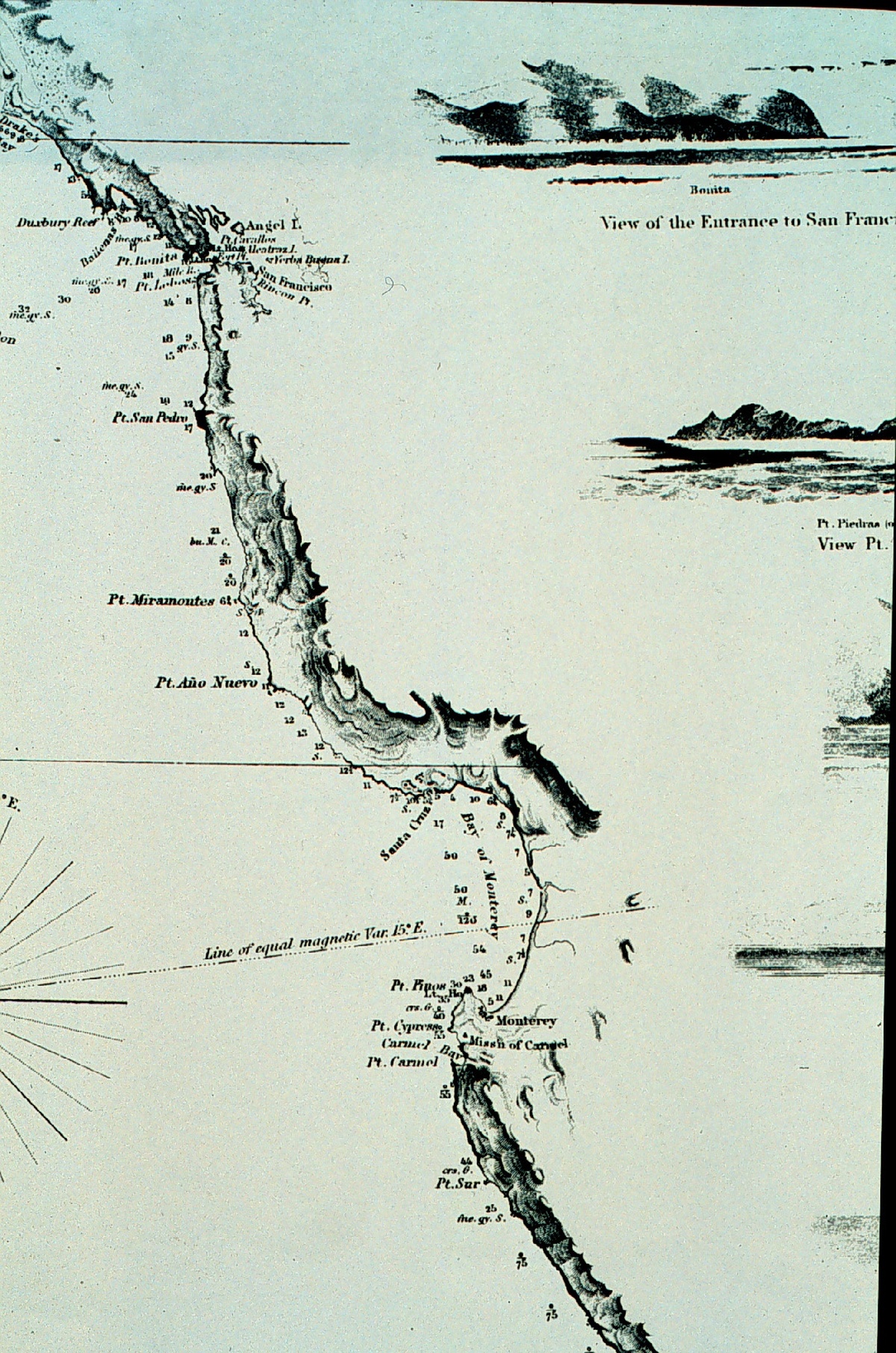
By the early 1850s, the Pacific coast presented an immense surveying task. A NOAA history of Coast Survey work in Southern California says that the Active, under Alden, made a first reconnaissance hydrographic survey from San Francisco to San Diego in 1852. Such trips helped establish positions for headlands, islands and harbors that navigators needed.
The ship’s name appears repeatedly in the early record of California charting. NOAA maritime historians note that Alden commanded the Pacific Coast-based Active until 1860. That long assignment gave him and his crews time to return to coastal problems, improve measurements and turn observations into charts that could be used beyond a single voyage.
The Coast Survey’s leaders were already pressing crews to look beyond a narrow shoreline. In 1845, superintendent Alexander Dallas Bache asked how the Gulf Stream varied in current, temperature, bottom character and marine life. The questions concerned a different coast, yet they show the agency’s broad approach. Ocean work joined navigation with systematic observation of the water and the ground below it.
From sounding lines to seafloor maps
Monterey Canyon was discovered long before modern sonar could scan broad stretches of ocean bottom. The early survey did not provide the kind of detailed image people now expect from bathymetric maps. It provided something just as important for its moment, evidence that a major valley lay below the surface and a measured outline of where deep water approached land.
Later tools made it possible to collect depths more quickly and with far greater detail. Yet the central habit remains familiar: map the sea by taking observations, locating them carefully and looking for the pattern they form. NOAA’s ocean exploration timeline places the Monterey finding among the early milestones that helped transform questions about the deep from speculation into measurable problems.
A discovery that still frames the bay
Historic charts offer a glimpse of the setting in which Alden worked. The NOAA Photo Library holds a reconnaissance chart of the California coast surveyed by Alden aboard the Active in 1852. It captures the practical purpose behind much early ocean observation: make the coast legible enough for people to travel it more safely.
Monterey Canyon’s first appearance in the record also belongs to the broader birth of oceanography. Coast Survey leaders were already studying depth, bottom character, temperature, currents and marine life. Alden’s “gulch” supplied a striking answer to one of those questions. The ground beneath the bay had its own shape and that shape mattered.
The 1857 finding still rewards attention because it joins a human story to a scientific one. A crew working with line, weight, chart and repeated measurements discovered a feature that had been hidden in plain sight. Their work made the underwater valley part of the known geography of California’s coast.





