
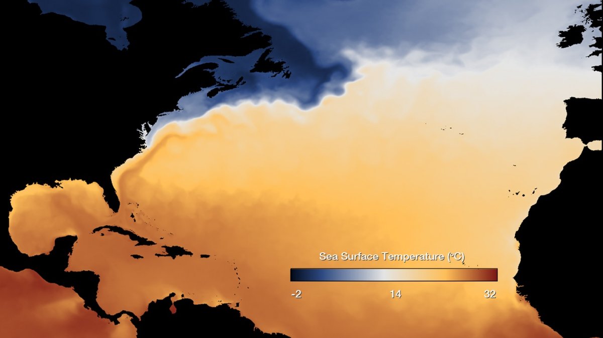
NOAA Ocean Service explains that ocean currents move seawater from place to place and help regulate climate by carrying warm water away from the Equator and cold water back toward it. Those moving waters help explain why coasts at similar latitudes can have very different weather. They also carry heat and moisture that influence storms, rainfall and sea life.
The sea stores much of the Sun’s energy, especially in the tropics. Currents spread some of that energy across ocean basins. Air above the water then picks up heat and moisture. Winds carry those changes toward land, where people experience them as milder winters, coastal fog, heavier rain, or long dry spells. This exchange gives ocean circulation a steady role in the climate of places far from the current itself. It makes the ocean a partner in everyday weather across the planet.
Two engines keep seawater moving
Wind powers much of the ocean’s surface movement. It pushes the upper ocean into broad loops called gyres. Earth’s rotation bends those flows, helping create clockwise patterns north of the Equator and counterclockwise patterns south of it. Continents shape the edges of each loop and channel water into stronger currents along some coasts.
Far below the waves, density drives a slower system. Water becomes denser when it cools or grows saltier. Dense water can sink, while lighter water stays nearer the surface. NOAA describes this temperature-and-salinity process as thermohaline circulation, a key part of the deep circulation that connects ocean regions over long periods.
The global ocean conveyor belt is a useful picture of that connected motion. In northern waters, surface water can lose heat to the air, become denser and sink. Deep water then travels great distances before mixing and wind-driven upwelling help bring it upward again. NOAA estimates that a parcel of water can take about 1,000 years to complete this broad circuit.
Surface and deep currents work on very different schedules. A wind-driven current can shift with the seasons, while deep circulation can take centuries to complete a large loop. Their shared effect is a moving network that transfers heat between the tropical ocean, polar regions and the atmosphere overhead.
Warm and cold currents change coastal weather
Warm currents move tropical heat toward higher latitudes. The Gulf Stream is one of the best-known examples. It runs north along the eastern United States before turning northeast across the Atlantic. Heat released from its waters can warm the air above and prevailing winds can carry that warmer air toward western Europe.
That effect helps make the climate of western Europe milder than many places at the same latitude. The ocean is one part of the climate system. Atmospheric circulation also transports large amounts of heat. Still, NOAA’s boundary-current lesson identifies the Gulf Stream as a powerful current that influences the climate of the U.S. East Coast and western European countries.
Cold currents leave a different mark. Along many coasts, winds can push surface water offshore. Colder, deeper water rises to replace it through upwelling. That water can cool the air above it and make the lower atmosphere more stable. Coastal areas near cold currents often see fog and low rainfall, while the rising water can also bring nutrients closer to the surface.
Those nutrients can support microscopic algae, which feed zooplankton and fish. For that reason, many upwelling areas are highly productive fishing grounds. The same ocean process can cool a coast and support a busy marine food web. Climate effects and ecosystem effects often begin with the same movement of water.
Pacific shifts can reach around the world
The tropical Pacific shows how changes in currents can shift weather far from the sea. During a typical period, trade winds push warm surface water westward. Colder water rises near South America. This pattern supports a difference in sea-surface temperature across the Pacific and helps organize rainfall.
During El Niño, trade winds can weaken and warm water can spread eastward. The usual coastal upwelling off South America also weakens. As the ocean surface changes, rising air and rain clouds can shift. The resulting changes can affect drought, flooding, monsoon patterns and storm seasons in many regions.
La Niña is the cooler phase of the same El Niño-Southern Oscillation cycle. Stronger trade winds generally reinforce the westward pileup of warm water and the rise of colder water in the eastern Pacific. Each event has its own pattern and strength, so local effects vary. The larger lesson is direct: currents shape the ocean surface that exchanges heat and moisture with the atmosphere.
These ocean patterns shift the likelihood of certain weather outcomes. Local forecasts also depend on seasonal winds, land conditions and other climate patterns. Scientists therefore compare each Pacific event with observations and forecasts before describing likely regional effects.
Scientists watch a changing Atlantic
The Atlantic has a major circulation pattern called the Atlantic Meridional Overturning Circulation, or AMOC. It includes warm near-surface water moving north and colder deep water returning south. Its pathways overlap with, yet are broader than, the Gulf Stream. Scientists track it because this circulation transports heat and nutrients through the Atlantic.
According to NOAA’s AMOC overview, cooling and sea-ice formation in northern waters can leave the surrounding seawater saltier and denser. That denser water sinks and flows southward at depth. Upwelling eventually returns water toward the surface. The process is slow, complex and linked to conditions across the Atlantic.
Climate change adds important questions to this system. Warming changes ocean temperature, sea ice, rainfall and freshwater input. Each can affect density and mixing. NOAA funds research into possible AMOC slowing, its connection to coastal sea level and its relationship with extreme events. Researchers are still working to measure change clearly and improve projections of what it could mean for regional climate.
Scientists use instruments, ocean floats, satellites and long records of temperature and salinity to follow circulation. Natural variation can make short records hard to interpret. Measurements collected over many years help researchers separate a brief swing from a lasting change in the larger ocean system.
Ocean circulation has always been part of Earth’s climate machinery. Today, satellites, instruments on ships, drifting floats and long-term measurements give scientists a clearer view of its movement. Following the paths of warm water, cold deep water and changing salinity helps connect conditions at sea with the climate people feel on land.





