
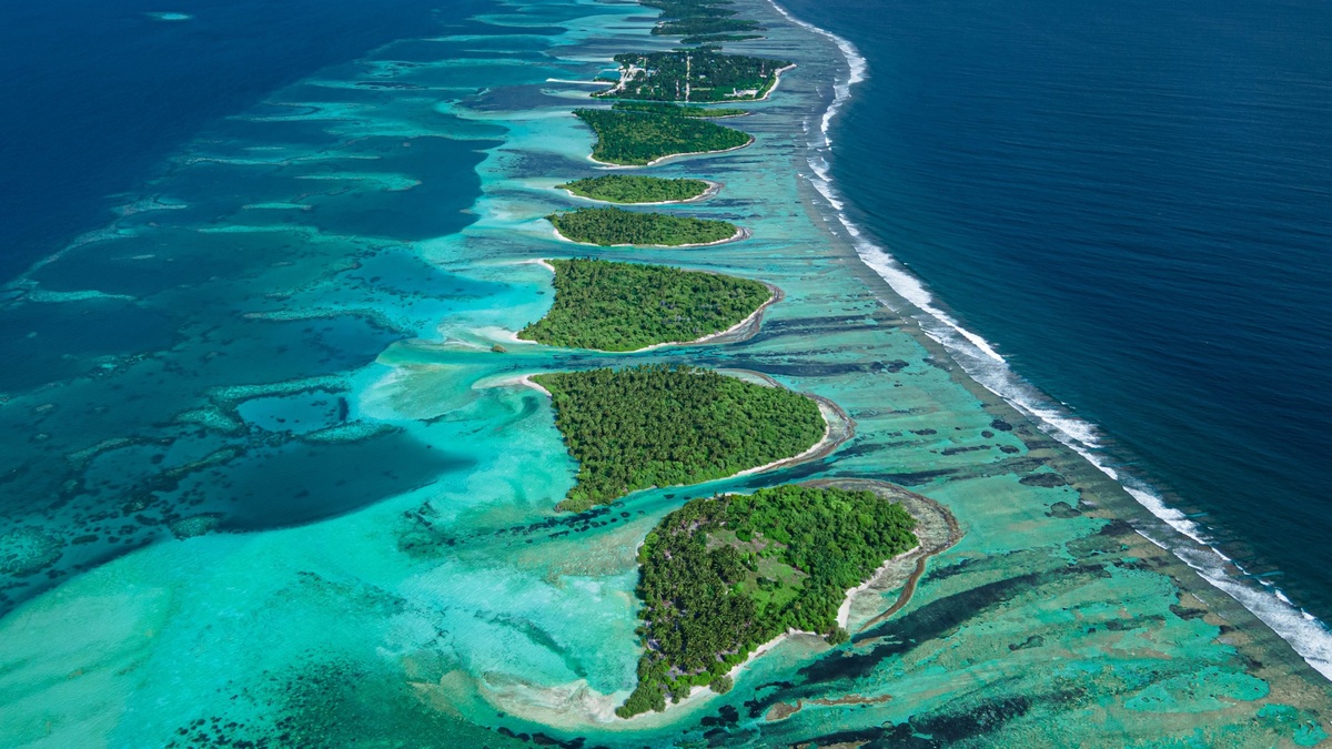
An atoll lagoon and a coastal lagoon are both sheltered bodies of water separated from a larger sea, but their barriers come from different geological settings. An atoll lagoon lies inside a ring or partial ring of coral reef in the open ocean. A coastal lagoon sits beside a continental or island coast, usually behind a sandy or gravel barrier.
The quickest way to tell them apart is to look beyond the water and identify the barrier. Coral framework surrounds an atoll lagoon. Shore-parallel sediment encloses most coastal lagoons. Their origins also differ: an atoll develops with a reef around a sinking oceanic island, while a coastal lagoon develops as shoreline sediment responds to wave action and changing sea level.
Both are dynamic environments rather than sealed ponds. Passes or inlets exchange water with the sea. Storms can alter those openings and moving sediment gradually changes the lagoon’s shape. The word “lagoon” describes the protected waterbody. It does not refer to the surrounding reef or island and many shallow bays have different origins.
What counts as a lagoon
The National Ocean Service definition describes a lagoon as water separated from a larger body by a natural barrier. That barrier can be a coral reef, sandbar or barrier island. A connection to the sea may remain through one or more inlets, allowing tides and currents to move water across the boundary.
Names on a map do not always follow the scientific definition. NOAA notes that Laguna Madre refers to a region containing bays and lagoons, while California’s Laguna Beach is a beach. Geography provides a better test than the place name. First identify the separating feature, then look for passages connecting the sheltered water to the sea.
Lagoons also differ from ordinary lakes because the barrier and exchange with a larger waterbody are central to their identity. A lagoon may be salty, brackish or locally fresher after rain and river flow. For comparison, Argo’s explanation of saltwater lakes covers inland basins whose salts accumulate without the same coastal barrier setting.
How an atoll lagoon forms
Atoll formation begins around an oceanic island where reef-building corals can grow. A fringing reef develops near the shore. As the volcanic foundation subsides or relative sea level rises, coral growth continues upward and a widening strip of water separates the reef from the remaining island. The result during this stage is a barrier reef and lagoon.
If the central island eventually disappears below sea level while the reef remains near the sunlit surface, the reef forms a roughly circular or oval rim around an open-ocean lagoon. NOAA’s coral reef tutorial explains that gaps in the reef connect the central water to the surrounding ocean. Sand and coral rubble may accumulate above sea level on parts of the rim, creating low islets.
Reef-building corals need suitable temperature, light and water chemistry, so this pathway is concentrated in tropical and subtropical seas. The volcanic foundation can lie far below the living reef by the time an atoll is mature. The lagoon records the space once occupied by the central island as subsidence and erosion reduce the land above water.
How a coastal lagoon forms
Coastal lagoons favor gently sloping shores where enough loose sediment is available for waves and currents to build a barrier. Sand may gather into a spit attached to land or into a barrier island running parallel to the coast. Water trapped between the barrier and the mainland becomes the lagoon.
Sea-level history, sediment supply and tidal range influence whether a lagoon persists. NOAA describes coastal lagoons as generally shallower and younger than atoll lagoons. Their exposed shore setting also makes them especially responsive to storms. An inlet can shift or close as waves move sand, then reopen during a later event.
The barrier itself is mobile. NOAA’s account of barrier islands explains that wind and waves continually move their sand. Dunes usually occupy the ocean-facing side, while marshes and tidal flats often develop on the protected side. These landforms can move landward as sea level rises rather than remaining fixed around the same lagoon outline.
A river may add fresh water and sediment to a coastal lagoon, producing large salinity differences from one end to another. Tidal inlets bring seawater inward. Rainfall and evaporation alter the balance, while each inlet’s dimensions govern exchange. One lagoon can therefore contain several distinct habitats.
Coastal barriers sometimes migrate across the inner water rather than simply enclosing it. Storm overwash carries sand from the ocean beach to the lagoon side. Repeated deposits can narrow the lagoon while helping the barrier move landward. Dams, dredging or inlet stabilization may interrupt that movement, so a modern shoreline can reflect natural sediment transport as well as engineering.
Depth, water exchange and habitats
Atoll lagoons are often surrounded by reef passes that focus tidal flow. Some contain patch reefs and deep central water, although atolls vary widely. Clear tropical water allows coral growth around the rim, while sediment produced by reef organisms can accumulate within the lagoon. The reef framework links the lagoon to the broader processes described in Argo’s article on coral reef dissolution.
Coastal lagoons are commonly shallow, so wind can stir bottom sediment and alter water clarity. Their inlet geometry controls how quickly ocean water replaces lagoon water. Restricted exchange can amplify warming or salinity changes, especially where evaporation is strong. Rivers and groundwater can push the same system toward fresher conditions.
Both types support rich habitat, yet the communities reflect local conditions. Seagrass beds may occupy illuminated bottoms. Sheltered margins can support mangroves or salt marshes where climate permits. Reef fish use atoll lagoons, while coastal lagoons frequently serve as nursery areas for species that later move offshore. Habitat boundaries respond to salinity as well as changing depth and wave energy rather than following a simple lagoon label.
Water residence time describes how long water tends to remain before exchange replaces it. A wide, deep pass can renew lagoon water efficiently, while a restricted opening can lengthen residence time. Longer residence can allow heat or pollutants to accumulate, including excess nutrients. Local winds and tides complicate the estimate, so two lagoons of the same type may behave very differently.
How to identify each type on a map
An atoll usually appears as a reef ring far from a continental coast, with a central blue area and one or more breaks through the rim. Satellite color can be misleading because water depth and bottom material affect the shade. A reef map or bathymetric layer helps confirm whether the pale rim is a reef platform, including any islets exposed above it.
A coastal lagoon appears as a long waterbody beside land, separated from the sea by a narrow shore-parallel barrier. Look for tidal inlets and rivers entering from the mainland. The broader map context is decisive: a coral ring around an oceanic center indicates an atoll setting, while a sandy barrier following a continental margin indicates a coastal lagoon. Argo’s overview of lake and pond differences offers a useful reminder that waterbody names alone rarely settle a geographic classification.
Map scale can hide the openings that connect either lagoon to the sea. Compare satellite imagery with a reef or shoreline layer, then check the date because storms can relocate an inlet. Atoll shape alone is also insufficient: submerged reef rims and platform reefs may enclose water without supporting permanent islands. The surrounding geology and barrier material provide the stronger classification.





